Liceul teoretic " Onisifor Ghibu
" Oradea,Bihor Profil:Engleza
intensiv Promotia:
2008-2009 


INTRODUCTION
There are multiple reasons why I've decided to
approach this theme.It was definetly a topic that offered me freedom of choise
and numerous directions of investigation, a topic that at the same time allowed me to make a
good documented presentation,because of the plenty of information I was able to
find but above all, the theme was of highly interest to me.
I
chose this subject first of all because National parks are great places to
explore nature, discover exciting animals and plants, have fun in the
outdoors,and I strongly believe this was a great opportunity to learn about
things I didn't know too much about.Nature reprezents for me the most
extrordinary thing , a blessing for everybody and of course National parks in the U.S.A need everyone's
help to remain America's most special places.
A national park is a reserve of land,
usually declared and owned by a national government,
protected from most human
development and pollution. National parks are protected
areas of IUCN category II. The
largest national park in the world is the Northeast Greenland National Park,
which was established in 1974. According to The World Conservation Union IUCN, there are now 6,555
national parks worldwide (2006 figure).
The National Park System of the United states
is the collection of physical properties owned or administered by the National
Park Service. This includes all areas designated National Parks and most
National Monuments, as well as several other types of protected areas of the United States.
In the first chapter I chose to speak, first off
all,about the history of the National Parks in America
.After that, in the next five chapters I will prezent five of the most
beautiful and famous parks the United
States .
CHAPTER
I: HISTORY OF NATIONAL PARKS
In
1810, the English poet William Wordsworth described the Lake District
as a 'sort of national property in which every man has a right and
interest who has an eye to perceive and a heart to enjoy'. The painter George Catlin,
in his travels through the American West, wrote in 1832 that the Native Americans in the United States
might be preserved 'by some great protecting policy of government . . . in
a magnificent park . . . A nation's park, containing man and beast, in all the
wild and freshness of their nature's beauty!' Similar ideas were expressed
in other countries-in Sweden,
for instance, the Finnish-born Baron Adolf Erik Nordenskild made such a
proposition in 1880. The Scottish-American naturalist John Muir
was an inspirational person in the foundation of national parks, anticipating
many ideas of conservationism, environmentalism, and the animal rights
movement.
Banff National Park, Alberta,
Canada
The
first effort by any government to set aside such protected lands was in the United States,
on April 20, 1832, when President Andrew
Jackson signed legislation to set aside four sections of land around
what is now Hot Springs, Arkansas to protect the
natural, thermal springs and adjoining mountainsides for the future disposal of
the US government. It was known as the Hot Springs Reservation. However no legal
authority was established and federal control of the area was not clearly
established until 1877.
The
next effort by any government to set aside such protected lands was, again, in
the United States, when President Abraham
Lincoln signed an Act of Congress on June 30, 1864, ceding the Yosemite
Valley and the Mariposa Grove of Giant
Sequoias (later becoming the Yosemite National Park) to the state of California:
|
|
The said State shall accept this grant upon
the express conditions that the premises shall be held for public use,
resort, and recreation; shall be inalienable for all time.
|
|
In 1872, Yellowstone National Park was established
as arguably the world's first truly national park. When news of the natural
wonders of the Yellowstone were first
promulgated, the land was part of a federally
governed territory. Unlike Yosemite, there was no state government
that could assume stewardship of the land, so the federal government took on
direct responsibility for the park, a process formally completed in October 1,
1890-the official first National park of the United States. It took the combined
effort and interest of conservationists, politicians and especially
businesses-namely, the Northern Pacific Railroad, whose route
through Montana would greatly benefit by the
creation of this new tourist attraction-to ensure the passage of that landmark
enabling legislation by the United States Congress to create Yellowstone National Park.
Theodore Roosevelt, already an active
campaigner and so influential as good stump speakers were highly necessary in
the pre-telecommunications era, was highly influential in convincing fellow
Republicans and big business to back the bill.
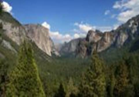
Yosemite
Valley, Yosemite National Park,
California, USA.
2.Yosemite National Park
The
'dean of western writers', American Pulitzer prize-winning author Wallace
Stegner, has written that national parks are 'America's best
idea,'-a departure from the royal preserves that Old World sovereigns enjoyed
for themselves-inherently democratic, open to all, 'they reflect us at our
best, not our worst.' Even with the creation of Yellowstone, Yosemite, and
nearly 37 other national parks and monuments, another 44 years passed before an
agency was created in the United
States to administer these units in a
comprehensive way - the U.S. National Park Service (NPS). Businessman Stephen
Mather and his journalist partner Robert Sterling Yard pushed hardest for
the creation of the NPS, writing then-Secretary of the Interior Franklin Knight Lane about such a need and
spearheading a large publicity campaign for their movement. Lane invited Mather
to come to Washington, DC to work with him to draft and see passage
of the NPS Organic Act, which was approved by Congress and signed into law on
August 25, 1916.
Of the 391 sites managed by the National Park Service of the United States,
only 58 carry the designation of National Park.
Following the idea established in Yellowstone
there soon followed parks in other nations. In Australia, the Royal National Park was established just south
of Sydney in
1879. Rocky Mountain National Park became Canada's first national
park in 1885. New Zealand had its first national park in
1887. In Europe
the first national parks were a set of nine parks in Sweden in 1909; Europe
has some 370 national parks as of this writing. In 1926, the government of South Africa
designated Kruger National Park as the nation's first
national park. After World War II, national parks were founded all
over the world. The Vanoise National Park in the Alps was the first French
national park, created in 1963 after public mobilization against a touristic
project.
The
United States
has an extensive series of national parks , monuments, historic sites,
shorelines, and scenic trails that protect natural and cultural sites
throughout the country.
Most
national monuments and all national parks are units of the United States
National Park Service (NPS) and are shown on the accompanying NPS maps. A few
monuments and preserves do not appear on the maps, as they are instead managed
by the National Forest Service (USDA FS), Fish & Wildlife Service (USFWS)
or Bureau of Land Management (BLM). As of 2007, the 'National Parks and Federal Recreational Lands
Pass' sold by the NPS for $80 ($10 for seniors over
62) allows free entrance to all sites managed by these organizations.
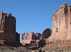
CHAPTER II: ARCHES
NATIONAL PARK
This is a United States
National Park
that is located in Utah's Canyon Country near the town of Moab. It is home to the world's greatest
concentration of natural arches, including the famous Delicate Arch that was
seen all over the world during the 2002 Salt Lake City Winter Olympics.
Arches National
Park preserves over 2000 natural sandstone
arches. This area contains the largest concentration of arches found any where
in the world, including the world-famous Delicate Arch as seen on the Utah
state license plate, in addition to a variety of unique geological resources
and formations. In some areas, faulting has exposed millions of years of
geologic history.The extraordinary features of the park, including balanced
rocks, fins and pinnacles, are highlighted by a striking environment of
contrasting colors, landforms and textures.
History
Throughout
the park, rock layers reveal millions of years of deposition, erosion and other
geologic events. These layers continue to shape life in Arches today, as their
erosion influences elemental features like soil chemistry and where water flows
when it rains. Arches is located in a 'high desert,' with elevations
ranging from 4,085 to 5,653 feet above sea level.
In
1923 Alexander Ringhoffer, a prospector, wrote the Rio Grande Western Railroad
in an effort to publicize the area and gain support for creating a national
park. Ringhoffer led railroad executives interested in attracting more rail
passengers into the formations; they were impressed, and the campaign began.
The government sent research teams to investigate and gather evidence. In 1929,
President Herbert Hoover signed the legislation creating Arches National Monument,
to protect the arches, spires, balanced rocks, and other sandstone formations.
In 1971 Congress changed the status of Arches to a National Park, recognizing
over 10,000 years of cultural history that flourished in this now famous
landscape of sandstone arches and canyons.
Landscape
To
many, the most outstanding natural features of Arches are the park's geologic
formations. Over 2,000 catalogued arches range in size from a three-foot
opening (the minimum considered to be an arch), to Landscape Arch which
measures 306 feet from base to base. Towering spires, fins and balanced rocks
complement the arches, creating a remarkable assortment of landforms in a
relatively small area.
Two
unusual natural features common in Arches intrigue both scientists and
visitors: cryptobiotic soil and potholes. Cryptobiotic soil is a living
groundcover that forms the foundation of high desert plant life.
Potholes
are naturally occurring basins or pools in sandstone that collect rainwater and
wind-blown sediment. These potholes harbor organisms that are able to survive
long periods of dehydration, and also serve as a breeding ground for many
desert amphibians and insects. Both of these communities are very vulnerable to
human impacts.
Flora and
fauna
The
plants and animals in Arches have many adaptations that enable them to survive
these conditions. Some species are found only in this area. The diversity of
organisms reflects the variety of available habitat, which includes lush riparian
areas, ephemeral pools, dry arroyos, mixed grasslands and large expanses of
bare rock. There are many jackrabbits that live here.
Climate
Southeast Utah is part of the Colorado Plateau, a
'high desert' region that experiences wide temperature fluctuations,
sometimes over 40 F (22 C) in a single day. The temperate (and most popular)
seasons are spring (April through May) and fall (mid-September through
October), when daytime highs average 60 to 80F (15 to 27C) and lows average
30 to 50F (-1 to +10C).
Summer
temperatures often exceed 100F (38C), making strenuous exercise difficult.
Late summer monsoon season brings violent storm cells which often cause flash
floods.
Winters
are cold, with highs averaging 30 to 50F (-1C to +10C), and lows averaging 0
to 20F (-18 to -7C). Though large snowfalls are uncommon (except in nearby
mountains), even small amounts of snow or ice can make local trails and roads
impassable. Local weather conditions and forecasts are available by phone at
(801) 524-5133.
Precautions Before You Visit
Stay on the path: Throughout the park and the Southwestern national parks,
you will see warnings about Cryptobiological soil. Foot prints erode the soil
and destroy years of growth.
Leave your dog at home: . As the climate indicates, there is extreme heat in the
summers. Perhaps more importantly, the environment is not supportive of
domesticated pets. There are reasons that there are still 1000 year old corn
cobs in archeological sites, items do not deteriorate like they might in your
back yard. Cactus and Fido do not make for good bedfellows.
Leave only your footprints, take
only photographs: Do not take rocks
or anyother type of souvienier from the park. Allow your grandchildren's
grandchildren to see the park as you see it when you visit it. Throughout the
southwest, you will walk right next to archeological sites. These are rapidly
disappearing as people take just one little thing back home.
Get in
a.
By air
Moab's Canyonland Field
Airport has daily service to Denver on Great Lakes Airlines. The closest
major airport is Salt Lake City International
Airport about a 4 hour drive away by way of
Interstate 15 and US Highway
6/191. The next closest airport is Denver International
Airport about 5
hours 45 minutes via Interstate 70.
b. By car
The
entrance to Arches National Park is located 5 miles north of Moab along US
Highway 191.
c.
By bus
Most
visitors see Arches
National Park on their
own, driving automobiles, riding bikes or hiking. However, there are a few
privately operated tour companies authorized by the National Park Service to
provide visitors with guided trips into the park:
- Canyonlands Tours/North
American River Expeditions,
543 N. Main, PO Box 1107, Moab, UT 84532, Ph: (800) 342-5938.
- Desert Highlights, 50 East
Center St., PO Box 1342, Moab, UT
84532, Ph: (800) 747-1342.
- NAVTEC Expeditions, 321
N. Main St., Moab,
UT 84532, Ph: (800) 833-1278.
- Tag-A-Long Expeditions, 452
N. Main Street, Moab,
UT 84532, Ph: (800) 453-3292.
- Moab
Adventure Center,
225 S Main Street, Moab, UT 84532, Ph: (888)
622-4097.
Fees/Permits
Park
entrance fees are $10 for private vehicles and $5 for individuals on foot,
bike, or motorcycle. These fees allow entrance for seven days. Alternatively,
the $85 Multi-Agency pass allows entry pass, amongst others, to all national
park areas for one year. It also allows entrance to parks of other agencies.
The $50 National Park Pass, which allowed entry to all national park areas for
one year was discontinued by the national parks service in 2007. If the
entrance booth is not manned, there is an electronic kiosk to pay the entrance
fee and receive a receipt to place on your vehicle's dashboard.
Get around
a.
By car
A
car is the most common way of exploring the park; most visitors will drive to
sites and then take short walks to view the amazing geologic formations of the
park. There are several four-wheel drive roads in the park's backcountry that
may appeal to those with appropriate vehicles.
b.
By foot
There
are numerous trails throughout the park, providing an alternative means of
travel for those not wanting to spoil the nature experience with a vehicle.
Hiking at or around sunrise (5-6 am) can provide a less crowded experience and
easier parking.
c.
By bike
Although
the summer heat can make a bike a masochistic way of viewing the park, in
cooler months it can be a popular option. Though there are no bike lanes and
traffic can be heavy at times, biking the scenic drive is a great way to see
the park. The Salt
Valley and Willow Springs
roads are less traveled but are more suited to mountain bikes due to
washboards, deep sand and other obstacles. Bicycles are only permitted on
roads: there is no single track or trail riding in the park. When biking on the
main road, please use caution and ride single file on the edge of the lane.
See:
- Park
Avenue.
A relatively easy one mile (one-way) trail located near the park entrance.
The trail leads through through a steep-walled sandstone canyon with a
smooth bottom. Many hikers will get dropped off at one end of the trail
and picked up at the other to eliminate the need for a round-trip.
Park Avenue in the morning sun
- Double Arch. A 0.8 mile roundtrip leads to Double Arch, a massive
joining of two arches that will be recognizable from the beginning of the
movie Indiana Jones and the Last Crusade. The trail is very easy
and located within walking distance of the Windows.
- Windows. The North & South Windows, as well as Turret
Arch, are located along an easy 1.0 mile roundtrip trail.
- Wolfe Ranch. Located near the beginning of the Delicate Arch
trail, this ranch is a restored homestead of John Wesley Wolfe, who
settled in the area in the late 1800s.
- Delicate Arch. The most famous arch in the park (and perhaps in the
world), Delicate Arch can be seen from a roadside turnout, from a short
0.8 mile trail, or you can take the 3.0 mile (roundtrip) trail starting
from Wolfe's Ranch, gaining 480 feet of elevation, and stand underneath
this natural wonder. The trail to the arch is strenuous; be sure to carry
adequate water with you. Note that during peak season you are likely to be
sharing the trail with many people; visiting at sunrise provides the best
chance of solitude, while sunset offers the best photography.
- Petrified Dunes. An overlook of the petrified dunes lies just off of
the park road between the Courthouse
Towers and the
Windows Area. These colorful formations are ancient sand dunes, hardened
into stone as additional layers built up on top of them and were later
eroded away.
- Fiery Furnace. The Fiery Furnace area is accessible only on
ranger-led tours, which can be reserved at the visitor center. The tour
leads through a maze of sandstone fins, showcasing one of the most
interesting geologic areas in the park. A fee is charged for this tour and
tours often sell out quickly, so trips should be booked as early as
possible.
- Devil's Garden Trail. Devil's Garden is a series of sandstone fissures that
are home to Landscape Arch (the park's largest), Double O Arch, and
numerous others. A series of trails lead to the arches, with Landscape
Arch only a 1.6 mile roundtrip from
the trailhead, while Double O Arch is a more strenuous 4.2 mile roundtrip.
Sadly, Wall Arch, once one of the most photographed arches in the park, is
no more, having collapsed in August 2008.
- Klondike Bluffs. Visited by only a very small fraction of the park's
tourists, Klondike Bluffs is located in the northwest corner of the park
and is accessible only by a dirt road or on foot. Tower Arch is located
down a short trail, as is the formation known as the Marching Men.
Do:
- Hiking. The park offers numerous short trails (see above)
ranging in difficulty from very easy to moderate.
- Photography. The park is a photographer's paradise with reddish
brown rocks, distant snow-covered mountains, and fantastic rock
formations. As with most places, light can be harsh during the day, so it
is best to have the camera ready during the early morning hours and late
evening hours. Delicate Arch and the Windows are best photographed at sunset,
while the light on Landscape Arch and Double Arch is best near sunrise.
- Rock climbing. Climbing is not allowed on most features named on
USGS maps, but is allowed on other formations.
- Backpacking. Limited water supplies and a lack of true backcountry
trails limit the appeal of backpacking in the park, although backcountry
use is allowed. Inquire at the visitor center for details.
- Wildlife Viewing. Almost 50 species of mammal are known to live in
Arches. Some, like desert cottontails, kangaroo rats and mule deer, are
common and may be seen by a majority of visitors. However, many desert
animals are inactive during daylight hours or are wary of humans, so
sightings can be truly special events. Tracks and scat are the most common
signs of an animal's presence.
Buy
There
is a cooperating association sales outlet in the visitor center that offers
books, maps, postcards, posters, and a variety of other educational and
interpretive items. For a larger selection, the town of Moab has everything necessary to satisfy your
shopping needs.
Eat
There
is no food available within the park. There is a water fountain at the parking
area near the Devil's Garden Trailhead. The nearby town of Moab offers a vast number of restaurants,
convenience stores, and grocery stores.
Sleep
Lodging
There
is no lodging within the park, although the nearby town of Moab has an enormous number of hotels to choose from.
Camping
There
is only one campground within the park, and reservations are highly recommended. Outside of the
park the Bureau of Land Management (BLM) operates several campsites Devil's Garden Campground. Located at
the end of the park road, this campground has 52 individuals sites and two
group sites. Water and flush toilets are available. Costs per site is $10 per
night. Between March 1 and October 31 up to 28 individual sites may be
reserved. Reservations can be made no less than 4 days and no more than 240
days in advance from www.reserveusa.com or by calling NRRS at 877-444-6777. There is an additional
$9 fee for reservations. The remaining 24 sites are first-come-first-served and
will be taken shortly after the park opens each day; stop at the visitor center
when it opens at 7:30 for the best chance at a site.
Backcountry
Arches
is a relatively small park, with very few areas far enough from roads to
qualify as backcountry. Outside the developed areas there are no designated
trails, campsites, or reliable water sources.
In order to backpack in Arches, you
must obtain a free backcountry permit at the visitor center. The maximum group
size is twelve, but smaller groups are strongly recommended to reduce impacts.
Permits may not be reserved in advance. Backpackers should know how to navigate
with a topographic map, recognize safety hazards and practice low-impact
camping specific to the high desert. Primary safety considerations include
steep terrain, loose rock, lightning, flash floods, and dehydration. Pets may
not accompany groups in the backcountry.
14.Stay safe
Summer
temperatures can reach or exceed 110F (43C), so it is important to carry (and
consume) enough liquid to keep you hydrated. One gallon of water per person per
day is recommended. When hiking on open rocky areas, be aware that lightning is
a danger during storms. Also, the dry sandstone-dominated terrain is
susceptible to flash floods during thunderstorms. The most intense
thunderstorms occur from July through September, during monsoon season.
Many
of the formations within the park are sandstone and can easily crumble when
climbing. Numerous individuals must be rescued each year after they scale a
formation and then discover that they cannot easily get back down; know your
limitations, and be aware that it is usually easier to climb up a
formation than it is to climb back down.
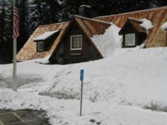
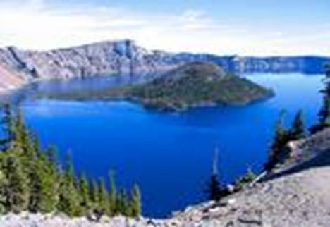
CHAPTER III: CRATER LAKE
NATIONAL PARK
Crater
Lake National Park is a United States national park located in
southern Oregon,
in the United States.
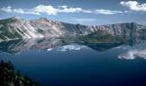
The centerpiece of the park is Crater Lake, the deepest lake in the United States,
known for its deep blue color.
History
Crater
Lake was formed from the collapse of Mount
Mazama, a volcano in southern Oregon that once stood
about 11,000 feet tall. A series of destructive eruptions around 5000 BC caused
the mountain's peak to collapse into its lava chamber, resulting in a caldera
nearly six miles wide. Over time, snowmelt and rain collected in the crater to
form the lake, which at 1949 feet deep, is presently the deepest in the USA, 2nd in North America,
and 9th in the world. Based on a comparison of average depths, however, Crater
Lake at 1148 feet, is the deepest in the Western Hemisphere and third deepest
in the world.
The first known white man to reach the lake was
prospector John Hillman, who found the lake in 1853. Largely through the
efforts of naturalist William Gladstone Steel, the United
States declared Crater Lake
a national park in 1902.
Crater Lake
Visitor Center
before the snow melt
Crater Lake's location high
in the Cascade mountains (about 6,000 feet
above sea level) means that snow is often visible year-round. The lake is often
enveloped in heavy snow during the fall, winter, and spring, forcing the
closure of roads and trails. In fact, the lake averages 533 inches of snow a
year. Consequently, the best time to visit Crater Lake
is in the summer months, when all facilities, roads, and trails are open.
Get in
a.
By
plane
The nearest major airport to
Crater Lake National
Park is Rogue Valley International-Medford
Airport, located three miles
north of Medford and 80 miles south of the park.
b.
By
car
Ø
From the north
- From Eugene, Portland,
and points north on I-5: Follow Interstate 5 south to Roseburg, then take Oregon 138 east to the park's north
entrance.
- From Bend and Central Oregon: Follow
U.S. 97 south to Oregon
138 west to the park's north entrance.
The north entrance is typically closed for the
winter season (mid-October to mid-June).
Ø
From the south
- From Medford and points south on I-5: Follow Interstate 5 north to
Medford, then take Oregon 62 north and east to the park's west entrance
(open year round).
- From Klamath Falls: Follow
U.S. 97 north to route 62 north and west to the park's south entrance
(open year round).
3.Fees/Permits
Entry fee is US$10.00 for
seven days. National
Park Passes
and Golden Passports are accepted.
4.Get around
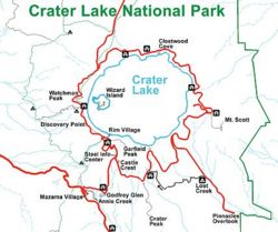
Map of Crater
Lake National Park
The
33-mile Rim Drive encircles Crater Lake, giving
varied perspectives of the lake, rim, and surrounding terrain. Open only during
the summer from late June to mid-October, there are many overlooks with
interpretive signs. The only access to the lake itself is by steep trail to
Cleetwood Cove, where boat tours of the lake are offered. Numerous picnic areas
are along the Rim Drive,
as is hiking access from Rim Village to Garfield
Peak. Rim Drive also
accesses Lightning Springs (west side), Cleetwood Cove (north side), Mount Scott
(east side), Sun Notch Viewpoint and Crater
Peak (south side). Both
Kerr Notch and Sun Notch Viewpoints are particularly spectacular viewpoints,
with views down to Phantom Rock and across the lake to Wizard Island.
There
are many trails open to horses. But, if you're not a cowboy then hiking the
trails is also a great experience. While on the trails keep an eye open for the
many buffalo grazing in the hills.
5.See
- The Pinnacles can be reached in the summer from the Rim Drive on a
paved, 6-mile road. These eerie spires of eroded ash rise from the edges
of Sand and Wheeler Creeks in pinnacle-fashion. On the way you'll pass
Lost Creek Campground. Once upon a time, the road continued east of the
turn-out, to the former East Entrance of the park. A path now replaces the
old road and follows the rim of Sand Creek (and more views of pinnacles)
to where the entrance arch still stands. An different route back to the Rim Drive, is
to take the Grayback Road,
a one-way, westbound only, gravel road.
- Steel Information
Center, Phone:
+1 (541) 594-2211, extension 402. Daily year round, except for Christmas
day. April - early November, 9AM-5PM. Early November - early April,
10AM-4PM. A park ranger is on duty to assist you with information, weather
forecasts, backcountry camping permits, ski route advisories, and safety
tips. A 20 minute film The Crater Lake Story describes the formation of
Crater Lake through a story passed down by Native Americans of this area
and is shown throughout the day in the auditorium.
- Rim Village
Visitor Center, located
on the south rim of the caldera, approximately 200 yards west of the
Crater Lake Lodge. Open early June through late September. General park information, backcountry camping permits, and
educational sales items are available here.
- Sinnott Memorial Overlook and Crater Lake Lodge. Both of
these facilities have interpretive displays and exhibits which are open to
the public in the summer.

Crater Lake
6.Do
- If you
want to explore the lake a little closer you should experience a boat tour. Only for those who are
willing to hike about 15 minutes down into the crater. Access is by 1.1
mile Cleetwood Trail which descends 700 feet to the lake surface. Guided
tours explore Wizard
Island. The price
can be expensive at $25 per person but it's well worth it
- Fishing Season May 20 through Oct 31; however, it is legal to
fish the lake year round. All waters in the park are open to fishing and
no license is required. Fishing is allowed in the park from 1/2 hour
before sunrise to 1/2 hour after sunset. All waters are restricted to use
of artificial lures and flies only.
No organic bait of any kind can be used in Crater Lake National
Park. This includes live or dead fish, power
bait, and fish eggs or roe. The lake contains Kokanee Salmon and rainbow
trout. No private boats or flotation devices are allowed. Fish must be
packed out, they can not be cleaned at the lake. Streams contain Eastern,
Rainbow, German Brown and Bull Trout. The streams, however, are largely
inaccessible due to the steep canyons surrounding them.
- Scuba Diving, Permits (no charge) are only issued from
the Canfield
Building (Ranger
Station) in the Park Headquarters complex. A ranger will confirm your
diving ability and give you specific information about diving in the lake.
The lake level is at 6,173 feet in elevation, so high altitude dive tables
should be used in planning your dive. Access is by Cleetwood Trail is 1.1
miles in length and descends 700 feet to the lake surface. You must be
able to carry all your equipment up and down the trail. Wheeled vehicles
are prohibited. Restrooms are available at the top and bottom of the
Cleetwood Trail but there are no food or drinking water facilities.
- Day Hiking. There are over 90 miles of trails, with marked routes
from 15 minutes to more than two hours. Hiking or climbing inside the
caldera is prohibited. Conditions within the caldera are extremely
dangerous. The Cleetwood Trail is the only safe and legal access to the
lake's shore.
Dogs and other pets are not allowed on park
trails.
Smoking is not allowed on any trail.
Bicycling is permitted only on paved roads and
the Grayback Drive.
Feeding wild animals, including birds, is
prohibited. Feeding animals is dangerous for you, bad for them, and harmful for
the ecosystem.
Stay on trails to protect vegetation and fragile
hillsides. Shortcutting trails, particularly on switchbacks, can damage slopes,
making them more susceptible to erosion and visual damage.
Be prepared, Equip yourself with water, food,
warm clothing, rain gear, and anything else appropriate to the trail you take.
It is better to be over-prepared than under-prepared.
Leave all rocks, plants and artifacts
undisturbed for the enjoyment of future hikers.
Do not drink water from park streams or from the
lake without properly treating it.
- Bicycling is welcome on the paved roads only, NOT trails. That
includes the 33 mile Rim Drive. Bicycling is difficult because of the
steep hills and high altitudes and also because the Drive may not have
shoulders and has blind curves. It is only for riders experienced with
traffic. Recommended only in July, August and September.
- Ski or snowshoe on ungroomed trails by permit only.
- Hunting is not permitted in Crater Lake National
Park.
7.Buy
While
exploring keep an eye out for the gift shop that has many interesting souvenirs
from paintings to postcards. You could even take home a custom carved wood
sign.
8.Eat
Crater Lake Lodge Restaurant, Phone: +1 541 594-1184, Rim Village.
Breakfast, lunch and dinner. Spectacular views of Crater
Lake. Dinner entres emphasize the Pacific
Northwest. Crater Lake
Lodge Restaurant pictures and information.
9.Drink
Be
aware that the waters there contain a lot of minerals and it is advised that
you bring your own water with you while hiking the trails.
10.Sleep
Ø
Lodging
The
Historic Prospect Hotel, 391
Mill Creek Drive.Built in the late 1800's and offers a cozy and comfortable
night's stay. Be aware that there is high demand and you should plan your
travels well in advance. They also have great breakfast
Park service facilities:
- Crater Lake Lodge, Phone: +1 (541) 830-8700, Open From 05/24/2006 To
10/16/2006. 71 rooms. Normally open mid-May through mid-October. Advance
reservations are strongly recommended.
- Mazama Village Motor Inn, Phone: +1 (541) 830-8700, Open From 06/02/2006 To
10/02/2006. Has 40 units and is located in the Mazama Village
complex. Reservations are recommended.
Ø
Camping
The National Park Service runs two campgrounds:
- Lost Creek Campground Open mid July to early October (weather
permitting). Has 16 tent sites.
- Mazama Campground, Open mid June to early October (weather
permitting). Has 200 sites, Reservations are not taken, however sites are
usually available. Running water, flush toilets, picnic tables, and fire rings
are provided.
CHAPTER IV: Everglades National Park
Florida Bay at Flamingo
looking North into Everglades
Everglades
National Park is a United States National Park and a UNESCO World Heritage Site in South Florida
in the state of Florida.
Everglades National Park,
protecting more than 1.5 million acres, is the 3rd largest national park in the
lower 48 states, behind Yellowstone National Park (2nd) and Death Valley National Park
(1st). During the dry season most facilities are open and a full range of tours
and programs are available to enjoy. During the wet season of June to
October, facilities may have restricted hours or close altogether, and
recreational opportunities may be at a minimum.
The
park has four visitor centers:
- Ernest Coe
Visitor Center, Homestead, +1 305-242-7700.
Nov-Apr: 8AM-5PM; May-Oct: 9AM-5PM. Open year round, this center offers
educational displays, orientation films, informational brochures and a
series of walking trails a short drive away. A bookstore with film,
postcards, and insect repellent. Restrooms.
- Flamingo Visitor Center, Flamingo, +1 239-695-2945.
Generally open from 8:30AM-5PM from mid-November to mid-April. Summer
hours are intermittent and subject to change. Educational displays,
informational brochures, backcountry permits and restrooms. Public boat
ramps are also located nearby. Several hiking and canoeing trails begin
nearby. No lodging is currently
available due to damage sustained by Hurricanes Katrina and Wilma(2007).
- Shark Valley Visitor
Center, Highway 41 (Tamiami Trail) (25 miles west of the
Florida Turnpike exit for S.W.
8th Street), Phone: 305-221-8776. Daily
8:45AM-5:15PM in winter, 9:15AM-5:15PM in summer. Hours subject to change.
In the heart of the 'River
of Grass', with
educational displays, informational brochures, and guided tram tours.
Bicycles may be rented at the center. Books, postcards, film, insect
repellent, and other items are available for sale. Vending machines
dispense snacks and soft drinks. Restrooms.
- Gulf Coast
Visitor Center, Everglades City, +1
239-695-3311. Daily, 8AM-4:30PM in winter; 9AM-4:30PM in summer. The
gateway for exploring the Ten Thousand Islands, a maze of mangrove islands
and waterways that extends to Flamingo and Florida Bay.
Offers educational displays, orientation films, informational brochures,
boat tours and canoe rentals. Backcountry permits available. Restaurants,
stores, lodging and campgrounds are nearby. Restrooms.
Landscape
- It's flat but don't let that fool you into thinking there is no
variety. A couple of inches of height brings a marked difference in flora
and fauna. The highest ground is populated by Dade County Slash Pine
forest, with underbrush that includes saw palmetto. Both plants encourage
fire which keeps the hardwoods out. A little lower 'altitude'
brings cypress heads, and lower than that swampland (a river of grass). In
the swampland, small hills (a couple of inches higher than water level)
are covered with tropical hardwoods with dense foliage below. As you get
to the south and southwest part of the 'glades, the tides bring in salt
loving plants like mangroves and their kin. There is a lot to see but it
takes paying attention to it -- and it is well worth the time. Things that
may seem small at first may be really big and bring fond memories.
Flora and fauna
Swimmers beware!
- The area is home to rare and endangered species, such
as the American crocodile, Florida
panther, and West Indian manatee. Over 1,000 species of plants live here.
- Collecting plants and animals in Everglades National
Park is prohibited. This includes such
things as orchids, airplants, seahorses, starfish, conch, tropical fish,
coral, sponges, and driftwood (except for fuel). One quart of non-occupied
sea shells may be collected per person.
Climate
Weather
is mild and pleasant from December through April, though rare cold fronts may
create near-freezing conditions. Average winter temperatures are: High 77F
(25C); Low 53F (12C). Summers are hot and humid, with temperatures around
90F (32C) and humidity over 90%. Afternoon thunderstorms are common and
mosquitoes are abundant. Hurricane season is June-November. Tropical storms or
hurricanes may affect the area. The rainy season is June through October,
coinciding with the mosquito season. Average Rainfall: 60 inches (152 cm) per
year.
Get in
a.
By plane
The
closest airport to the Everglades is Miami International
Airport. It is a
hub for American Airlines, which
has service within the United States
and to the Caribbean, South America, and Europe.
b.
By car
Two
US Highways serve the Everglades from Miami:
Route 41 which runs west, and Route 1 which runs south.
Fees/Permits
Entrance fees: Vehicles $10 for 7 days. Pedestrian/bicyclist $5 for 7
days. Everglades National Park Annual Pass $25 is valid for twelve months from
the date of purchase. It admits the purchaser and any accompanying persons in a
single, private, non-commercial vehicle, or the purchaser and accompanying
immediate family (spouse, children, parents) when entry is by other means
(bicycle, foot, and boat). Activity
fees: Camping Fees at park campgrounds: $14 per night. Backcountry
Camping Fees (Permit Required): $10 per permit plus $2 per person per night.
Maximum 14 days.
Get around
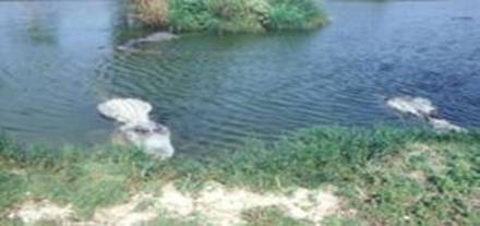
Gators in Flamingo, FL
See:
- Florida Bay Approximately 85% of Florida Bay is inside of
Everglades National Park. Access to boats and tours is available at Flamingo, inside of the park. There are
over 200 islands referred to as 'keys'. It is a salt water body,
at the south end of the Everglades, where fresh water meets salt water.
The 'floating logs' that you likely will see are more likely
American Crocodiles or possibly American Alligators.
They swim Florida Bay and to the islands.
Do:
- Visit 'Royal Palm /
Anhinga Trail'
is the best area for easily viewing wildlife, especially in the dry
season. The 'glades are a vast, shallow, slow moving river of grass that
extends from Lake Okeechobee in the North to Florida Bay and East to West
almost the width of the state. During the dry season (winter through May
depending on the year) it dries up except for the deeper places. From the
main trail the Anhinga are two very productive wildlife areas as they stay
wet all year long. If you bring children and child-like adults, please
instruct them to walk quietly and keep their voices down so they
don't scare the more timid animals. You will probably see alligators,
great blue herons, anhingas, double-crested cormorants, garfish, bass,
talapia (and other fishes), various turtles (hard and softshell), snowy
egrets, tri-color herons, greenback herons, -- and you might see one or
more of the following: deer, stilts, great white herons, bitterns,
limpkins, purple gallinules, avocets, roseate spoonbills, ibis, woodstork,
snail kites (Everglades kites), sandhill cranes (along the dry bed before
you get to the Anhinga Trail), and many other species -- and if you are
VERY lucky, a Florida Panther. Take your time, bring your binoculars and
camera, and enjoy the wildlife and natural beauty. It is also fascinating
to come during the night when the alligators feed. Ranger guided tours of
the trail are available frequently and can be very interesting as they are
usually very knowledgeable about the local flora and fauna and can help
spot more wildlife than you would yourself.
- Visit 'Eco Pond'
and other trails Eco Pond
used to be one of the best areas for viewing birds and other wildlife.
However, the 2005 hurricane season transformed Eco Pond from a freshwater
environment to a saltwater environment as well as significantly damaging
the area. Thus, there is much less wildlife left. However, it is still
possible to see some wildlife there as well as all the other trails found
in the park. Wood Storks are often seen at Eco Pond (as of February 2007)
and it is possible to see Southern Bald Eagles in the southern areas of
the park.
- Shark Valley Tram Tours, +1 305-221-8455. A guided two-hour narrated
tram tour along a fifteen-mile loop in the heart of the 'River of
Grass'. Tours depart from the Shark Valley Visitor Center and provide
a great opportunity to see wildlife, while escaping the heat and bugs of the
wet season. Reservations are strongly recommended for the dry season.
Bicycle rentals are also available here.
- Everglades National Park Boat
Tours, Gulf Coast Visitor Center. +1
239-695-2591. A narrated boat tour of the Ten-Thousand Islands. Canoe rentals
are also available to explore nearby waterways. Reservations are strongly
encouraged during the busy dry season.
- Flamingo Lodge, Marina, and
Outpost Resort, +1
239-695-3101. Offers boat tours through the Florida Bay and Whitewater Bay
areas of the park. Reservations are strongly recommended during the busy
dry season. The Flamingo Lodge and
Marina sustained major damage due to Hurricanes Katrina and Wilma. Boat
rentals, lodging and restaurants are not currently available (2006).
While some boat tours have resumed, visitors are strongly encouraged to
phone for current schedules and pricing. This is also one of the better
areas to see American Crocodiles, which are often found on the canal bank
opposite the Marina store.
- Cypress Airboat Rides, +1 561-798-2884. Open year round. Explore this
ecosystem on a heart pounding ride, or a more relaxed airboat tour.
- Fishing for tarpon, bonefish, redfish, snook, snapper, and sea
trout. Separate Florida licenses are necessary for freshwater and
saltwater. There are very few areas where fishing from shore is possible.
If you want to fish, consider hiring a local guide. There are plenty of
great Florida guides that will meet you in the Everglades for a day of
amazing saltwater fishing, whether you want use a fly, conventional
tackle, or bait. The back country is word renowned for snook and baby
tarpon.
- Boating. Boat ramps within Everglades National Park are
located at Flamingo, Little Blackwater Sound, and West Lake. Several
commercial boat ramps are located in Everglades City and Chokoloskee. Note
that there are closed areas, motor-restricted areas and no wake zones. See
the Park's
Boating Regulations.
- Water skiing and use of
personal watercraft such as jet skis is prohibited.
Eat
Everglades
City has a few great seafood restaurants that serve local fare, including fried
alligator.
- The Seafood Depot, 102 Collier Ave, Everglades
City located in a train depot established in 1928. It has
wonderful outside dining overlooking the mangroves and water of the
backcountry. The food is plentiful and very affordable.
Drink
Key West Sunset Ale from the Florida Brewing Company
Landshark Lager from Jimmy Buffet's Margaritaville brand of food and drink
Sleep
a.
Camping
Two
drive-in campgrounds are located within the park. Both campgrounds can accommodate
tents and RVs. A limited number of group sites are also available. Leave-no-trace camping principles apply.
- Long Pine Key Campground is located six miles from the Ernest Coe Visitor
Center. Sites are available in the Long Pine Key Campground on a
first-come, first-serve basis only. Reservations are not accepted.
- Flamingo Campground is located near the Flamingo Visitor Center on the
shores of Florida Bay. Reservations are accepted at the Flamingo
Campground, and are strongly recommended. Reservations can either be made
online or by calling 1-800-365-CAMP.
Fees: Nightly fees are $16 per site
at either campground (2006). If you have a Golden Age card (U.S. Citizen 62 or
over) or a Golden Access Card (permanently disabled), camping is half price.
This does not apply to group sites, which are $30 per night. Owing to limited
usage and difficult conditions, camping is typically free of charge during the
wet season.
b.
Backcountry
Visitors
can select between a variety of ground sites, beach sites and elevated camping
platforms (sometimes called chickees). Most sites are accessible by canoe,
kayak or motorboat, though a few may be reached by hikers. Visitors should be
aware that none of the park's 47 backcountry sites are accessible by car.
Backcountry trips here require more planning than most. Reference the Park's
Wilderness Trip Planner.
A
backcountry permit is required for all wilderness campsites. Permits are only
issued the day before or the day of the start of your camping trip. Permits are
not issued over the telephone. Wilderness permits are written from the Ernest
Coe Visitor Center only for two land sites in the Long Pine Key area: Ernest
Coe and Ingraham Highway. For all other campsites, permits may be obtained at
the Flamingo and Gulf Coast Visitor Centers. Winter wilderness users whose
trips originate from the Florida Keys can obtain permits by phone by calling +1
239-695-2945 for the following locations only: North Nest Key, Little Rabbit
Key, Carl Ross Key, and the Cape Sable Beaches. Permit Fees: $10 per permit
plus $2 per person per night.
Stay safe
American Alligators at Everglades
- The American
Alligator CAN be a very dangerous predator but, despite a very
strange outbreak of fatal attacks last year, it rarely attacks humans.
Avoid interacting with alligators during mating season, and you will be
fine. It is extremely common in the Everglades and it is estimated that
more than 1 million alligators reside in Florida alone- that is more than
all other populations of crocodillian species combined- so caution should
always be taken. Take those numbers and measure them against the amount of
people who swim in Florida's rivers each year and you will find that the
chance of attack is very low. In contrast, if people swam in northern
Australia's rivers as much as they do in Florida's they would have
hundreds or thousands of crocodile related fatalities every year. The
alligator grows to 14.5 feet, although seeing individuals over 13 feet is
extremely rare for this species.

American Crocodile
- American Crocodiles exist in some parts of the Everglades and can grow
considerably larger than their alligator relatives. They are, however,
very rare and can only be found in considerable numbers in a few isolated
pockets along the southern coast. There have been no official documented
attacks on humans in Florida by this species, mainly due to it's poor
distribution (there are estimated to be between 500 and 1000 crocodiles in
Florida). They have been known to grow up to 20 feet in length in Costa
Rica, but crocodiles of 15 feet are considered large in Florida. This
species, like Crocodylus Porosus, can be found out to sea and does
occasionally swim between islands in the Caribbean and in Florida.
- Mosquitos What the species of mosquitos at the Everglades lack
in size, they make up for in quantity. The mosquitos are abundant during
summer months, descriptions include being dense enough to suffocate cattle
and camping lanterns. They can make a visit to Flamingo unbearable if one is not
prepared. There are restrictions on use of insecticides. Mosquito level
information is available at +1 305-242-7700 (8:30AM-4PM), during
summer months.
- Raccoons The Everglades has a species of masked raccoons that
grow to be the size of small bears. The mask is very appropriate, as they
will quietly burglarize your camp site if given the opportunity.
- Reptiles The Everglades are home to an extensive variety of
reptiles (alligators, snakes and such), being the cold blooded animals
that they are, they are always looking for opportunities to warm up in the
Florida sun during the colder months and the heat from the road pavement
at night. When driving through the park to Flamingo at the tip of the Everglades, you
may encounter large alligators and snakes basking in the sun in the middle
of the road or soaking up the heat from the road at night. Alligators will
likely move on, others may not. Avoid touching or hitting any, it will not
be a good experience.
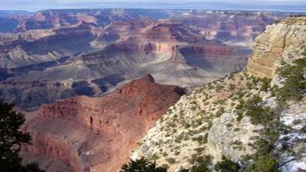
CHAPTER V:
Grand Canyon National Park
Grand Canyon National Park
is a United States National Park and a UNESCO World Heritage Site that is located
entirely in northern Arizona
and is one of the great tourist attractions in the United States.
There are two ways to approach the Canyon: the remote North Rim and the more accessible (and therefore more crowded) South Rim. Both areas have several
options for camping, as well as hotels and restaurants. Expect all of these
facilities to be overflowing with visitors during the busy summer season. Fall,
spring, and winter are all great times to visit the Grand Canyon.
The
Canyon is an overwhelming experience, and nothing can prepare a visitor for the
sight. The Grand Canyon is a massive canyon carved over several million years
by the Colorado River. Grand Canyon National Park boasts an elevation change of
nearly 7,000 feet (2130 m) from Point Imperial (at nearly 9,000 feet or 2740 m)
to the banks of Lake Mead (at just over 2,000 feet or 610 m). The canyon itself
is, from rim to river over a mile (1610 m) deep. In spots the rock layers
exposed in the canyon display over two billion years of geologic
history.
History
The
park was founded as Grand Canyon National Monument in 1908 by President
Theodore Roosevelt, and became a national park in 1919. Today the park contains
over 1.2 million acres (490,000 ha), slightly less than the entire state of Delaware,
and in 2004 received more than 4.3 million visitors.
Landscape
Throughout
the past century, hundreds of authors have attempted to depict the enormous
landscape that is Grand Canyon. Not surprisingly, words most often fail to invoke
the sense of awe and wonder that many visitors experience. Edward Abbey, a
noted Southwest author, once penned: "Those who love it call it the canyon. THE
canyon. As if there were no other topographic feature on the face of the
Earth".
There
are, of course, other canyons on the planet. Some are longer, others wider, and
even some that are deeper. Canyon visitors are often surprised to learn that
Grand Canyon sets no records for sheer size. It is, however, simply regarded by
most as the "grandest" canyon of them all.
Geologically,
the canyon extends from Lee's Ferry near the Arizona/Utah border to the Grand
Wash Cliffs near Las Vegas, a distance of 277 miles. It ranges in width from
about a quarter mile to over 18 miles wide. In places the canyon is over a mile
deep.
However, it is not the statistics that define this
landscape as "grand", but rather a combination of factors. The desert
environment and a lack of herbaceous ground cover reveal a geologic story that
is unparalleled. Surprisingly, the rock layers displayed at Grand Canyon show
little sign of wear. The layers have been preserved almost perfectly, as though
they were layers in a cake. Nowhere else on Earth displays so many volumes of
the planet's history in such pristine condition.
The
resulting landscape provides visitors with some of the most magnificent and
unsurpassed vistas on the planet.
Flora and fauna
Arguably,
the most famous animal in the park is the rare California Condor. They can
occasionally be seen flying near Grand Canyon Village on the South Rim. Common
bird life includes Canyon Wrens, Stellar's Jays (with their peaked caps),
swallows, hummingbirds, and the playful and entertaining Raven.
Mule
Deer are common. Some of the largest Elk in North America can be found in the
national park, and in the adjacent Kaibab National Forest. Desert Big Horn
Sheep are also seen on occasion, mainly in the inner canyon.
You'll
often spot Coyote no matter where you are in the park, and if you're lucky,
you'll get to hear them sing. Other predators are Mountain Lions and Bobcat.
Black Bears are rare, and they generally stay away from the inhabited areas.
Some
of the smaller creatures that can be found in the inhabited areas of the park
are the Ringtail (called a cat, but not in the cat family), which like to live
in the rafters of some of the historic buildings on the rim. They are quick and
stealthy, but they often forget how visible that tail is, and you'll see it
hanging out over a beam.
A
favorite with visitors is the Abert's Squirrel with their tufted ears. Other
varieties of squirrels and chipmunks are also popular. They seem tame and like
to beg for food behind the Bright Angel Lodge, near the Ice Cream fountain. But
heed the warnings and resist the urge. One of the most common injuries in the
park are squirrel bites.
You
might also see the common Striped Skunk, and if lucky, you might even see the
rarer Western Spotted Skunk (usually at lower elevations). Skunks here are also
habituated to humans and may seem tame, but they will react as all skunks do,
so don't come up on them suddenly!
For
the reptile family, there are variety of small lizards, and a few snakes. The
most striking (in more ways than one) is the Grand Canyon Rattlesnake; with its
reddish (almost pink) coloring it neatly blends into the rocky terrain of the
canyon. They are interesting to see as long as it is at a safe distance.
Rattlesnakes are MORE afraid of you than you are of them. If given the chance,
they will avoid any contact with humans. Most rattlesnake victims are young
males that are chasing or trying to capture a snake.
Do not feed the animals. It is unhealthy for them, and may be
unhealthy for you. A seemingly tame squirrel might bite you--they carry plague,
rabies, etc. A deer or elk can charge at you without warning. If the animal is
aware of your presence, you're too close.
Climate
Temperatures
and weather within the park vary greatly by location. Temperatures on the North
Rim are often 20 to 30 degrees F (11 to 16 degrees C) cooler than at the river.
This is a land of extremes. It can be snowing at the rim, while others are
comfortable sunbathing at the the river. Conversely, it can be cool and
comfortable at the rim in the summer, while temperatures at the river exceed
120 degrees F (49 degrees C). It is not unusual for local canyon guides to
encounter neophyte hikers in desperate shape. Some die. An unusual number of
fatalities occur among young males who overestimate their abilities.
South Rim
(Average Elevation 7000 feet)
|
|
Jan
|
Feb
|
Mar
|
Apr
|
May
|
Jun
|
Jul
|
Aug
|
Sep
|
Oct
|
Nov
|
Dec
|
|
Average High (F)
|
|
|
|
|
|
|
|
|
|
|
|
|
|
Average Low (F)
|
|
|
|
|
|
|
|
|
|
|
|
|
|
Average Precipitation (inches)
|
|
|
|
|
|
|
|
|
|
|
|
|
North Rim
(Average Elevation 8000 feet)
|
|
Jan
|
Feb
|
Mar
|
Apr
|
May
|
Jun
|
Jul
|
Aug
|
Sep
|
Oct
|
Nov
|
Dec
|
|
Average High (F)
|
|
|
|
|
|
|
|
|
|
|
|
|
|
Average Low (F)
|
|
|
|
|
|
|
|
|
|
|
|
|
|
Average Precipitation (inches)
|
|
|
|
|
|
|
|
|
|
|
|
|
Inner
Canyon - River Level
(Average Elevation 2100 feet)
|
|
Jan
|
Feb
|
Mar
|
Apr
|
May
|
Jun
|
Jul
|
Aug
|
Sep
|
Oct
|
Nov
|
Dec
|
|
Average High (F)
|
|
|
|
|
|
|
|
|
|
|
|
|
|
Average Low (F)
|
|
|
|
|
|
|
|
|
|
|
|
|
|
Average Precipitation (inches)
|
|
|
|
|
|
|
|
|
|
|
|
|
Get in
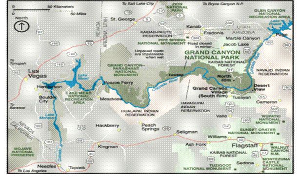
Grand Canyon area map
a.
By
car
The
majority of visitors to the South Rim of the park arrive from the south on
Arizona Route 64 (AZ 64) (conjoined with US highway 180). Alternately, one can
enter the south rim from the east on AZ64.
For the south entrance: from Flagstaff,
you can take US Route 180 (US 180) northwest to Valle where it joins with AZ
64, and continue north to the south rim; or take I-40 west toward Williams to
the junction with AZ 64 and continue north to the south rim. Both routes are
approximately 80 miles (129 km). The approx 60 miles (97 km) on US 180 is a
narrow 2-lane mountain road through a heavily forested area. The I-40 west is a
wide multi-lane interstate for approx 20 miles (32 km), to AZ 64 which is a
slightly wider, less mountainous 2-lane highway, and the recommended route
during winter weather. There are two lanes at this entrance reserved for pass
and prepaid entrance fees (now lanes 1 and 4), which can be pre-purchased
outside of the park at the National Geographic Theater/Visitor Center.
For the east entrance, take US 89 south from Page,
AZ or north from Flagstaff
to the junction with AZ 64 at Cameron. It is approx 25 miles (40 km) from the
junction to the east entrance of the park, and approx 25 miles (40 km) from the
east entrance to the south rim village area.
Visitors to the North Rim use ALT US 89 to AZ 67
(closed in winter).
b.
By
air
Many
Grand Canyon visitors fly into one of two metropolitan airports located within
half a day's drive of the South Rim: Las Vegas McCarran International Airport
(LAS), which is 275 miles from the South Rim or Phoenix Sky Harbor Airport
(PHX), 230 miles from the South Rim.
Flagstaff's Pulliam Field (FLG) is the nearest
commercial airport to the canyon. Two daily flights from Los Angeles (LAX) are
offered by Horizon Air, and US Airways operates five daily flights from
Phoenix. Commuter flights are also available from Phoenix to Page-Lake Powell,
Arizona (PGA) on Great Lakes Air, 145 miles Northeast of the park .
Grand Canyon National Park Airport (GCN) is located
just outside of the South Rim entrance in the town of Tusayan. It is primarily
utilized by companies who provide Grand Canyon air tours and private aircraft.
Scheduled air service from Las Vegas to the Grand Canyon is offered by Scenic
Airlines, departing out of the Boulder City Municipal Airport (61B). Private
charter service is available from other cities. Generally, though, visitors fly
commercial airlines into the larger airports in Flagstaff, Phoenix, or Las
Vegas.
c.
By
bus
Open
Road Tours, 877-226-8060. runs a daily shuttle service to the South Rim from
Flagstaff.
There
are currently no bus lines offering transportation to either rim. However,
several commercial tour companies offer guided tours originating in Flagstaff,
Phoenix,
Las Vegas,
Los Angeles
and other locations, either directly to the South Rim or that include the South
Rim as part of an itinerary, and a few offer tours which include a visit to the
North Rim.
d.
By
guided tour
A
number of companies provide guided tours of the Canyon that include
transportation from the surrounding areas. Some companies will provide bus
travel from nearby towns while others begin in the park. Some will provide just
a brief tour with small stops, while others may take you on a hike, and arrange
all your meals.
- Angel's
Gate Tours, 800-957-4557. offers day tours, day hiking excursions, and
overnight backpacking trips in the canyon. Transportation is available
from Flagstaff, Williams, and the South Rim Area.
- BikeRaft.com,
1-800-624-6323. offers a variety of different tours, from the beginner to
the expert, of the Colorado River including most parts of the Grand
Canyon.*
- Colorado
River & Trail Expeditions, 800-253-7328 offers trips and tours to the
best parts of the Grand Canyon. They specialized in rafting and hiking
along the river corridor.
- Discovery
Treks, 1-888-256-8731 or 480-247-9266 Rated one of the "Best Adventure
Travel Companies on Earth" by National Geographic Adventure magazine,
specializes in custom and semi-custom, guided treks at Grand Canyon
National Park, Havasu Falls and Sedona. Arranges treks for small groups as
well as corporate or large groups with trips for all fitness levels
- Grand-Adventures.com,
800-618-0744. Offers fully guided daily walking tours from Las Vegas. All
tours include small groups of 10 or less, a picnic lunch on the rim, a
McDonald's breakfast, CD slideshow of your tour, free t-shirt, and 3.0
hours at the South Rim.
- Grand
Canyon Tours, 800-301-7152. Offers scenic views of the Canyon by airplane,
helicopter, bus, Jeep, and more. Also serving the surrounding area with
tours to and from Boulder City, Flagstaff, Las Vegas, Los Angeles,
Phoenix, Sedona, Tempe, and Williams.
- Hydros
Adventures Tours, 928-310-8141. Offers one day and overnight hiking,
rafting, backpacking, and adventure tours to the Grand Canyon, Northern
Arizona, and Southern Utah. Pickups in Phoenix, Las Vegas, and the Grand
Canyon area.
- Just
Roughin' It Adventure Co, 877-857-2477. Just Roughin It offers Grand
Canyon hiking tours for backpacking, day hiking & canyoneering in
arizona including hermit trail, south bass, south kaibab, rim to rim,
grandview trail, horseshoe mesa, havasu falls, tonto trail and many more.
- Pygmy
Guides LLC, 877-279-4697. Offers all inclusive day tours, day hikes, and
overnight backpacking in Grand Canyon and surrounding areas.
Transportation from Flagstaff, Williams, Tusayan, and Grand Canyon South
Rim hotels.
- Silver
Spur Tours, 800.600.4006 Offers an
all-day Grand Canyon South Rim Loop Tour from Sedona and Flagstaff,
Arizona. Customized Mercedes-bult Sprinter Vans limited to seven tourists.
VIP pickup at your hotel. Loop Tour includes scenic Desert View Drive with
stops at popular overlook points. Gourmet picnic included.
- Vaughan's
Southwest Custom Tours, 800-513-1381. offers both day and overnight tours,
standard or customized, to the south rim from the Phoenix/Scottsdale area.
e.
By
train
The
Grand Canyon Railway operates a train ride from the town of Williams to the
Grand Canyon Village (travel time is 2.5 hours in each direction). The terminus
at Grand Canyon Village is within walking distance of some accommodations. The
train features an historic steam locomotive during the summer season, restored
Pullman cars, and a staged old west style shootout. However, the Grand Canyon
is not visible from the train. It is simply another option for traveling to the
canyon, and takes about twice as long as driving to the canyon.
Amtrak's Southwest Chief, with trains operating daily between
Chicago and Los Angeles, stops at Williams Junction, with connections to the
Grand Canyon Railway.
Fees/Permits
All private vehicles
entering the Grand Canyon must pay a $25 entrance fee, which is good for seven
days. Individuals on foot or on a bike must pay a $12 entrance fee, also good
for seven days. Exceptions: those holding an Annual Pass ($80, good for one
year), Senior Pass ($10, good for life, available to US citizens 62 and older)
or an Access Pass (free, available only to citizens or permanent residents of
the United States who are medically determined to be blind or permanently
disabled). Note: An Access Pass can only be obtained in person by showing proof
of medically determined permanent disability, or eligibility for receiving
benefits under federal law.
Get
around
Some
of the view points are reachable by car, park service shuttle, motorcoach tour
or on foot.
You
can go into the canyon by horse, by mule (through guided tours on the south rim
from Xanterra), on foot or by
boat.
Private stock users (equines only) are required to
follow a number of rules and restrictions while in the park, and must get a
permit from the park service for overnight use. See Private Stock
Use on the park service website for specifics.
From
March through November the West Rim Drive is not accessible to most private
vehicles (handicap vehicles may request a variance at the entry gate). The park
service runs a shuttle during this time. The shuttles are frequent, but long
lines form during the busy summer months.
Trans
Canyon Shuttle an independent shuttle service runs between the North and the
South Rim (No website, Tel 1.928.638.2820).
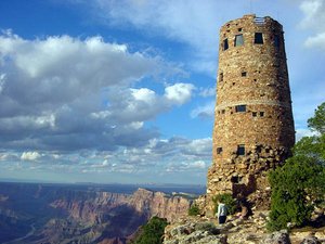
See
The
Watchtower.
a.
South
Rim
- Grand Canyon Village. Good views, the trailhead of the Bright
Angel Trail, historic buildings, and massive crowds.
- Desert View. The historic Watchtower is a popular stop for many
travelers and provides an excellent vantage point for viewing the canyon
and Colorado River.
- Hermits Rest. Located at the West end of Hermit Road.
This gift shop/snack bar was designed by Mary Colter (the same person
responsible for the Watchtower at Desert View) so as to resemble a
Hermit's abode, and fit in harmoniously with the landscape. Constructed of
a mix of stone and wood.
There
are several other viewpoints along the road between Hermit's Rest and Grand
Canyon Village (West Rim) or Desert View and the village (East Rim).
b.
North
Rim
Located
only ten miles from the South Rim by air, the North Rim is a 215 mile (346 km),
five hour drive from Grand Canyon Village. At 8,000 feet (2,440 m) the
elevation of the North Rim is approximately 1,000 feet (305 m) higher than the
South Rim, and as a result features more coniferous trees and cooler
temperatures. The roads to the North Rim are open only during the summer (from
approx May 15 to the first fall snow fall), while the in-park facilities
usually close by October 15, regardless of the weather. With far fewer
visitors, this area can be a great place to enjoy the peace and majesty of the
canyon. The main viewpoints are Bright Angel Point, Cape Royal (where the
Colorado River can be seen), and Point Imperial (the highest viewpoint in the
park).
c.
Havasupai Indian Reservation
Currently
closed to visitors due to flood damage. It is expected to re-open to visitors in the
Spring of 2009.
A
popular destination in the canyon lies southwest of the park on the Havasupai
Indian Reservation. Havasupai can be loosely translated as
'People of the Blue-Green Water'. Entry into this remote portion of
the canyon requires a $35 per person entry fee (plus an additional $17 per
person/night to stay in the campground). Those venturing into Havasu Canyon are
greeted by spectacular world class waterfalls. Although the Havasupai
Reservation is somewhat impacted (trashy), the incredible canyon below the Supai
Village is worth the visit. Access to Havasu Canyon is from Hualapai Hilltop
north of Peach Springs, Arizona. It is an eight mile hike or horse back ride to
Supai Village. Helicopter transportation to and from the village is available
on a first come basis four days a week. An extremely rustic lodge is the only
public accommodation available in Supai. A large mile long campground is
located two miles down canyon between Havasu and Mooney Falls. This campground
can be extremely crowded in the summer months; advance reservations are
strongly recommended.
d.
Hualapai Indian Reservation (Grand Canyon West)
The
Hualapai Reservation borders Lake Mead NRA to the West, and Grand Canyon
National Park to the North and East. Tribal head quarters are located in the
heavily impoverished town of Peach Springs, Arizona. The Grand Canyon Resort Corporation
is a collection of tourist enterprises wholly owned by the tribe. Activities
include motorized rafting trips on last few miles of white water in the canyon,
and pontoon boat rides on the smooth waters of Lake Mead. In addition, Grand
Canyon West (located in the remote Northwest corner of the reservation) is a
collection of viewpoints overlooking the last few miles of Grand Canyon and the
stagnant waters of the Colorado River as it flows into Lake Mead. The Hualapai
have partnered with dozens of commercial tour operators from the Las Vegas
area, and a tour package purchase (ranging from $29-$109 per person) is
required for entry to the Grand Canyon West area. Literally hundreds of
helicopter flights ferry passengers from the 'West Rim' to a
multitude of landing zones near the lake shore.
At
Eagle Point, the Grand Canyon Skywalk (a glass bottomed walkway extending over
the rim) is now completed. This construction has received much recent news
coverage. Access to this part of the Canyon is rather difficult, it requires
you to drive for approximately 14 miles on a dust road ('Diamond Bar
Road') after the town of Dolan Springs, Arizona.
Hualapai Reservation (West Rim) Fees:
- 25$
parking fee per vehicle at West Grand Canyon Airport (a bus tour is
required to visit any of the points)
- 25$ per
person for a bus tour which will take you to Eagle Point and a pile of
stones beyond
- 25$ per
person to enter the skywalk
- No
photographs may be taken by yourself on the skywalk for security reasons,
you may instead have a photograph taken of you (25$ per photograph)
Do
a.
Hiking
- Nature walks. Many visitors take a stroll along
portions of the rim trail to enjoy the magnificent views. Deer, elk, big
horn sheep are just a few of the animals that can be seen at Grand Canyon.
This is one of the few places on earth where you may spot the endangered California
Condor soaring in the seemingly primordial sky.
- Hiking. Trails range in difficulty from fifteen minute loops
to multi-week treks. The most popular trail is the Bright Angel Trail
leaving from Grand Canyon Village near the Bright Angel Lodge. During the
summer months water is available at the 1.5 mile (2.4 km) resthouse, the 3
mile (4.8 km) resthouse and Indian Gardens (4.5 miles or 7.2 km). However,
check to ensure that the water is functioning before departing; water main
breaks are common. The South Kaibab Trail down to Cedar Ridge (1.5 mi
one-way) is also quite popular. There are numerous unmaintained trails
throughout the park for the more adventurous. A few outfitters offer
guided hikes (see guided tours in the 'Get In' section).
b.
Whitewater
rafting
Whitewater
rafting expeditions depart daily during the summer months from Lee's Ferry.
Commercial trips range from 3 to 18 days and cover from 87 to 300 miles. Trips
book up fast so be sure to book your trip about a year in advance or you will
have to get lucky with cancellations. The most popular section of river for the
'true' Grand Canyon river experience lies between Lee's Ferry and
Diamond Creek. The Grand Canyon River Outfitters
Association provides a complete list of outfitters for this section
of river.
- Rivers & Oceans, (800)473-4576 works closely with all 16
outfitters offering between 1-16 day trips. They are an experienced
proffesionals with over 21 years in the whitewater rafting industry and
can save one much time finding the perfect river trip in an exact
time-frame.
The
only one day whitewater trip is available from the Hualapai Tribe's Hualapai
River Runners in the far Western portion of the canyon (outside of
the park boundary) near Las Vegas. The only other option for a one day river
trip is a one day flat water float by Colorado River Discovery
in Glen Canyon (just outside Grand Canyon National Park).
- Colorado River and Trail Expeditions, +1-800-253-7328,. Offers all
inclusive rafting vacations. Expeditions range from 4 to 12 days. Special
Interest Trips include Natural History, Hiking, and Kayak Trips. There is
truly no better way to see the Grand Canyon than from the River. Not only
is the canyon incredible, but so are all of the side canyons. Waterfalls,
Indian ruins, springs, slot canyons, and old miner hideouts abound in the
side canyons of the Grand Canyon.
Private
(non-commercial DIY) river permits are also available for river trips up to 30
days in length. The new Colorado
River Management Plan has changed a 12-20 year waitlist to a new
weighted lottery. For more information on obtaining a non-commercial permit,
visit the Grand Canyon
Private Boaters Association.
c.
Other
activities
- Ranger programs. Programs include interpretive talks, rim
walks, movies, and museums. At the South Rim, special Junior Ranger
programs are available for children in the summer. Check 'The
Guide', a free publication distributed throughout the park for dates
and times.
- Motorcoach tours are available year round at the South Rim.
Tours are offered for the East Rim/Desert View, West Rim/Hermit's Rest,
and for Sunrise and Sunset. Smaller naturalist and geologist lead van
tours originate from outside the park in Flagstaff, Williams and Tusayan
(see guided tours in the 'Get In' section).
- Mule rides. South Rim trips operate year round, and should be
booked well in advance due to demand. Individuals can book by calling Xanterra at
888-297-2757 (1-303-297-2757 from outside of the US). Weight limits of 200
pounds (90.7 kg), and other restrictions are strictly enforced.
- Star gazing. On your own (fantastic for meteor showers), or with
the Grand Canyon Star Party every June at Yavapai Point.
- Imax Movie. Visitors to the south rim can go to the National
Geographic Imax theatre outside of the park in Tusayan to see half hour
presentation of 'Grand Canyon, the Hidden Secrets'. Showtimes
are every hour on the half hour.
- Air Tours. Fixed-wing (airplane) and Helicopter tours are
offered by providers outside of the south rim in Tusayan at the Grand
Canyon Airport, and also from Las Vegas, NV. Scenic flights are no longer
allowed to fly below the rim within the national park. However, some
helicopter flights land on the Havasupai and Hualapai Indian Reservations
within Grand Canyon (outside of the park boundaries). Helicopter tours are
available with Maverick Helicopters,
for those who prefer fixed wing aircraft try Air
Grand Canyon.
- Bicycling is only allowed on park roads. It is not allowed on
rim trails or in the inner canyon. The best mountain biking can be found
on the North Rim and just outside the park in the Kaibab National Forest. Rim
Tours offers multiday mountain bike tours on the North Rim, and
bike rentals may soon be available on the South Rim.
- Educational Courses The Grand Canyon Field Institute
offers short (1 to 5 day) courses at the canyon. Northern Arizona
University in Flagstaff offers a Grand Canyon Semester
for college credit.
Buy
All
types of tourist trinkets relating to the Grand Canyon, native American
Indians, and the American Southwest are available in shops in Grand Canyon
Village on the South Rim. The South Rim is overflowing with shopping options.
The North Rim has only one shop located at the North Rim Lodge.
- Hopi House. This gift shop designed by Mary E. J. Colter turned
100 years old in 2005. It specializes in Native American crafts: Navajo
Rugs, Hopi Kachina's, Zuni Fetishes, pottery, jewelry as well as t-shirts
and souvenirs. The upstairs gallery offers Native American artworks.
- Lookout Studio. Also designed by Colter features
spectacular views of the canyon from it's overhanging patio, and
specializes in rocks and fossils along with the souvenirs.
- Hermit's Rest. Another Colter building blends into the
canyon and offers a variety of souvenirs.
- Verkamps,. One of the last privately held parcels within Grand
Canyon National Park. Near the El Tovar hotel, it turned 100 in 2006.
Eat
a.
South
Rim
- Arizona Room. Located on the East side of the Bright
Angel Lodge. Dinner 4:30pm-10:00pm (open seasonally), lunch seasonally.
Also features partial canyon views.
- Bright Angel Restaurant. Located in Bright Angel Lodge. Informal
dining, open for breakfast, lunch and dinner.
- El Tovar Hotel Dining Room. Fine dining for breakfast, lunch
and dinner. Reservations required for dinner (not accepted at other
times). Dining room is a flashback to the 1910s and features partial
canyon views. $20 for lunch, $30 for dinner.
Additional
Cafeterias are located in the Maswik and Yavapai Lodges. There is a grocery
deli at Market Plaza inside the grocery store, as well. Just outside the park,
in the gateway community of Tusayan, are a number of dining selections.
b.
North
Rim
- Grand Canyon Lodge Dining Room. Open daily, Mid-May through
Mid-October (exact dates vary year to year), 6:30am-9:30pm. Wonderful food
and an unrivaled view of the canyon. Serves breakfast, lunch, and dinner.
Dinner reservations required. $7-$25.
- Cafe On The Rim. Serves cafeteria-style snacks, breakfast,
lunch and dinner. Veggie burgers, salads, sandwiches. $1-$10.
- Coffee Saloon. Located in the Rough Rider Saloon.
Coffee, bagels, and pasteries. 5:30am-10:30am.
Drink
a.
South
Rim
- El Tovar Lounge. South Rim in the El Tovar Hotel. Inside
seating year round, patio seating overlooking the rim seasonally.
- Bright Angel Bar. South Rim in the Bright Angel Lodge. Live
entertainment seasonally.
- Maswik Sports Bar. South Rim in Maswik Lodge. Pool table,
darts, big-screen TV and more.
b.
North
Rim
- Grand Canyon Lodge Dining Room.
North Rim. Serves cocktails.
- Rough Rider Saloon.
North Rim.
Sleep
There
are a variety of hotels, lodges, and campgrounds both inside and outside of the
park on both the North and South Rims. As lodging at the Canyon is fairly
expensive, many visitors opt to base themselves in Williams or Flagstaff
instead.
a.
Lodging
South Rim
The
following lodges are located inside Grand Canyon National Park, reservations
can be made by contacting Xanterra. If you want to
try your luck with same-day reservations, call (928) 638-2631.
- El Tovar Hotel. Historic full service hotel on the rim,
refurbished in 2005, open year round. The finest accommodations available
on the South Rim, and reservations must be made well in advance.
Some suites boast a canyon view. $150-300.
- Kachina Lodge and Thunderbird Lodge. Rim lodges built in the 60s, but renovated
in 2004, open year round. Half the rooms face the canyon.
- Bright Angel Lodge. Historic Lodge at the rim, made up of
cabins and lodge rooms generally rustic in nature. Some rooms without
bathroom. Some are located rim side. Open year round.
- Maswik Lodge. North section renovated winter 2006.
Larger rooms are great for families. Located about a quarter mile off rim
in a wooded area. Both North and South sections are open year round, and
cabin rooms open in the summer.
- Yavapai Lodge. East section renovated 2003. Located
about a mile away from the rim in a wooded area, both East and West
sections are good for families.
Just outside the South Rim - Tusayan
Hotels
in Tusayan are often a better choice for families with children, or for those
who are looking for a greater selection of amenities such as swimming pools and
hot tubs.
- Best Western Squire Inn, 800-622-6966.. It's the canyons only
resort-style property.
- The Grand Hotel, 888-634-7263.. The newest hotel in the
area, with the lobby done up in a kitschy Wild West theme. Rooms are
nondescript but adequate. Indoor pool, free wifi in lobby. Popular, so
book ahead.
- Holiday Inn Express Grand Canyon, 888-473-2269.. 164 guest rooms
plus 30 one- & two-bedroom mini-suites as well as a new indoor pool
& spa.
- Red Feather Lodge, 106 Highway 64, Grand Canyon, AZ 86023 +1
800-538-2345, [24]. Get your Grand
Canyon vacation off on the right foot by reserving a room at the Red
Feather Lodge, an affordable, pet-friendly Arizona hotel convenient to
Grand Canyon National Park Airport.
North Rim
- Grand Canyon Lodge, 888-297-2757.. Offers a variety of cabins
and motel style accommodations.
Inner Canyon
- Phantom Ranch is made up of cabins and dormitories
(segregated by gender) with a dining hall. All Phantom Ranch
accommodations and meals require advance reservations. There is no cooking
allowed in the cabins or dorms, and guests without a meal reservation are
not allowed in the dining hall at mealtimes. It is recommended that you
reserve meals at the same time you reserve your bunk or cabin. Guests
should check in at the Bright Angel Lodge Transportation desk before
hiking down to Phantom Ranch, and can do so a day in advance of their
hike. Individual reservations can be made by calling Xanterra at
888-297-2757 (outside of the US call 303-297-2757).
a.
Camping
Campgrounds
are located at both the North and South Rims. Reservations are highly
recommended, especially at the busier South Rim. Outside of the park, Kaibab National Forest has numerous
undeveloped campsites and 'at large' camping is allowed for up to 14
days. Due to extreme drought conditions, check for closures and camp fire
restrictions.
South Rim
- Mather Campground (Year round). Located in Grand Canyon
Village, this campground offers sites suitable for camping and RVs (no
hookups). Facilities include water and flush toilets. Costs are $18/night
from April through November, $12/night from December through March.
Reservations can be made at reservations.nps.gov
or by calling (800) 365-2267, outside the U.S. call (301) 722-1257.
- Trailer Village (Year round). Located adjacent to Mather
Campground, this campground offers RV sites with hookups. Costs are
$25/night for two people, and $2 for each additional person. Reservations
can be made by calling (888) 297-2757 (outside of the U.S. call
303-297-2757).
- Desert View Campground (May - October). Located 26 miles east of
Grand Canyon Village, this campground offers tent and RV sites (no
hookups). Costs are $10/night. All sites are first-come, first-served.
- Ten-X Campground (April - September). Located outside of
the South Rim of the park, two miles south of Tusayan, this campground is
operated by the forest service. Facilities include water and pit toilets.
Costs are $10/night. All sites are first-come, first-served.
North Rim
- North Rim Campground (May - October). Located along the North
Rim, this campground offers sites suitable for camping and RVs (no
hookups). Facilities include water and flush toilets. Costs are
$15-$20/night. Reservations can be made at reservations.nps.gov
or by calling (800) 365-2267, outside the U.S. call (301) 722-1257.
- Jacob Lake Campground (Summer only). Located outside of the
park, 45 miles (72.4 km) north of the North Rim, this campground is
operated by the forest service. Costs are $12/night. All sites are
first-come, first-served.
b.
Backcountry
Any
camping below the rim in Grand Canyon requires a backcountry permit.
Permits must be obtained through the Backcountry Country Office (BCO) at Grand
Canyon National Park. Permits are currently not available online or via
telephone. They are only available in person, by fax or by mail.
Permits are limited to protect the canyon, and
become available on the 1st day of the month, four months prior to the start
month. Thus, a backcountry permit for any start date in May becomes available
on January 1. Space for the most popular areas, such as the Bright Angel
Campground adjacent to Phantom Ranch, generally fill up by the requests
received on first date they are opened to reservations. There are a limited
number permits reserved for walk-in requests available on a first come, first
served basis.
There are a number of outfitters that provide fully
guided backpacking trips (including permits and gear) at Grand Canyon.
There is limited water available within the canyon,
so backpackers should plan on carrying sufficient water with them.
All backcountry users are asked to follow 'Leave no Trace' principles.
Stay
safe
Hiking
at the Grand Canyon often surprises people who attempt Inner Canyon trips. It
can be hotter than you'd expect, colder than you'd expect, drier or wetter. A
prepared hiker is better able to survive the extremes of the canyon. Even for
short walks into the canyon keep in mind that it is a seducer: it seems easy
hiking down into it but when you come back up you find that you have
over-extended yourself. It's the opposite of climbing up a tall mountain, where
you can stop and turn back when you get tired, knowing that the descent will be
much easier.
In particular, do not attempt to hike to the
bottom of the canyon and back in one day. Hundreds of hikers each year have
to be rescued from the Inner Canyon due to exhaustion and dehydration.
While the temperature on the canyon rim is cool due to its elevation, below the
rim it can be very hot. The vertical distance from the bottom back up to the
rim is nearly a mile straight up (1.5km), in addition to the distance
you travel horizontally. If you plan to go to the bottom of the canyon, spend
the night (permit required), and take enough food, water, shelter, and
other backcountry camping equipment to keep yourself safe and sound. If you
don't have the equipment, don't go.
For
an eye-opening look at the dangers of hiking in and around the canyon
unprepared, Over the Edge: Death in Grand Canyon by Thomas M. Myers
(long time resident doctor at the south rim), and Michael P. Ghiglieri
(biologist and river guide), describes the various ways in which visitors have
lost their lives at the canyon.
CHAPTER VI: Yellowstone
National Park
Yellowstone National Park is
a United States National Park and a UNESCO World Heritage Site. It was the
world's first national park, set aside in 1872 to preserve the vast number of
geysers, hot springs,
and other thermal areas, as well as to protect the incredible wildlife and
rugged beauty of the area. The park is principally contained within the northwest
corner of Wyoming,
but also extends into the states of Idaho and Montana.
The
calcite terraces at Mammoth Hot Springs. These springs flourished with water
until the late 1970s, but are currently dry.
Yellowstone
is the first and oldest national park in the world and covers 3,472 square
miles (8,987 km²), mostly in the northwest corner of Wyoming. The park is
famous for its various geysers, hot springs, and other geothermal features and
is home to grizzly bears, wolves, and free-ranging herds of bison and elk.
History
Long
before any recorded human history in Yellowstone, a massive volcanic eruption
spewed an immense volume of ash that covered all of the western U.S., much of
the Midwest, northern Mexico and some areas of the eastern Pacific Coast. The
eruption dwarfed that of Mt. St. Helens in 1980 and left a huge caldera.
Yellowstone typically erupts every 600,000 to 900,000 years with the last event
occurring 640,000 years ago. Its eruptions are among the largest known to have
ever occurred on Earth, producing drastic climate change in the aftermath.
Although it is commonly assumed that the park was named for the yellow rocks seen
in the Grand Canyon of the Yellowstone, the park's name comes from the
Yellowstone River that flows through it, which is in turn named after sandstone
bluffs found further down its course in eastern Montana.
In
1872, Yellowstone became the first National Park reserve declared
anywhere in the world, by President Ulysses S. Grant. In 1978 it was designated
a World Heritage Site by UNESCO.
Landscape
Geological
characteristics form the foundation of an ecosystem. In Yellowstone, the
interplay between volcanic, hydrothermal, and glacial processes and the
distribution of flora and fauna are intricate and unique. The topography of the
land from southern Idaho northeast to Yellowstone results from millions of
years of hotspot influence. Some scientists believe the Yellowstone Plateau
itself is a result of uplift due to hotspot volcanism.
Flora
and fauna
The
park is the core of the Greater Yellowstone Ecosystem, one of the largest
intact temperate zone ecosystems remaining on the planet. Black bears, grizzly
bears, deer, elk, bison, bighorn sheep and wolves can all be found within the
park borders.
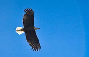
Raptors
such as Bald Eagles (pictured above), Golden Eagles, and Falcons are commonly
seen throughout the park. This Bald Eagle was photographed while hunting for
prey near Mammoth Hot Springs, in the northern portion of the park.
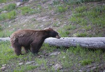
It
is not at all unusual to see many types of bears, like this black bear, near
the roadways or up on the ridges of Yellowstone in the summertime, usually
foraging for food.
Geothermal
Features
Primary
geothermal features include geysers, mud pots, hot springs and fumaroles, which
exist because of the active volcano that Yellowstone sits on top of. Geothermal
features are formed by superheated water heated by the volcano. The pressure is
so intense that it gets released into the air as hundreds of gallons of
steaming water, or, when the pressure is not as intense, hot springs or mud
pots are formed. Various colors of the pool are due to different types of
bacteria growing in different temperatures. A good way to learn about the
geothermal features is through the Young Scientist Program. Please check with a
Ranger at the Old Faithful Visitor Center.
Climate
The
weather in Yellowstone National Park can change very rapidly from sunny and
warm to cold and rainy, so it's important to bring along extra layers of
clothing which can be used as needed.
- Summer: Daytime temperatures are often in the 70s (25C) and
occasionally in the 80s (30C) in lower elevations. Nights are usually
cool and temperatures may drop below freezing at higher elevations.
Thunderstorms are common in the afternoons.
- Winter: Temperatures often range from zero to 20F(-20C to
-5C) throughout the day. Sub-zero temperatures over-night are common. The
record low temperature is -66F (-54C). Snowfall is highly variable. While
the average is 150 inches per year, it is not uncommon for higher
elevations to get twice that amount.
- Spring & Fall: Daytime temperatures range from the 30s
to the 60s (0 to 20C) with overnight lows in the teens to single digits
(-5 to -20C). Snow is common in the Spring and Fall with regular
accumulations of 12' in a 24 hour period. At any time of year, be
prepared for sudden changes. Unpredictability, more than anything else,
characterizes Yellowstone's weather. Always be equipped with a wide range
of clothing options. Be sure to bring a warm jacket and rain gear even in
the summer.
Get in 
Official map from the National Park Service; in the public
domain and not protected by copyright.
a.
By
air
Yellowstone
is located far from any major airports. The principal airport serving
Yellowstone is the Jackson Hole Airport
(IATA:
JAC) located within Grand Teton National Park. Non-stop flights
to Jackson Hole are available from Atlanta, Chicago, Dallas, Denver, Los Angeles, and Salt Lake
City. Most service is seasonal.
As service to Jackson Hole Airport is infrequent and
expensive, a better method of entering Yellowstone is by flying into Salt Lake
City, (a major hub for Delta Air Lines, the world's largest
commercial airline) and driving to Yellowstone via I-15 and US 20-a distance of
roughly 320mi (515km) or about 5-6 hours.
Small
airports with limited/seasonal commercial service can be found in:
Montana
- Billings (IATA: BIL)
- Bozeman (IATA: BZN)
- Butte (IATA: BTM)
- West Yellowstone (IATA: WYS)
Idaho
Wyoming
Alternative airports may have less airline service
than Jackson Hole.
b.
By
car
The
park has 5 entrances. The nearest cities to each entrance are given. Most are
within 5 miles of the park boundary.
- North
- Accessed from Gardiner (which is reached via US Route 89
from Livingston) - This entrance leads to
the park headquarters at Mammoth
Hot Springs, 5 miles inside the park boundary. This entrance road
is open all year.
- Northeast - Accessed from Silver Gate and Cooke City via US Route 212. This entrance
road is open all year, though you cannot use Route 212 in winter.
- East
- Accessed from Cody
via US Route 14/16/20. This entrance is closed in winter (early November
to early May).
- South
- Accessed from Grand Teton National Park
via US Route 89/191/287. This entrance is closed in winter (early November
to early May).
- West
- Accessed from West Yellowstone via US Route
20/191/287. This entrance is closed in winter (early November to late
April).
Fees/Permits
All
vehicles and individuals entering the park must pay an entrance fee that is
valid for seven days. The entrance fee provides entry to both Grand Teton and
Yellowstone National Parks. Fees are $25 for non-commercial vehicles, $12 for
hikers and cyclists, and $20 for motorcycles and snowmobiles.
One
year passes are available as an alternative to the seven day fee. The Park
Annual Pass is $50 and provides entrance to Yellowstone and Grand Teton
National Parks. The Interagency Annual Pass is $80 and provides entrance to
most federal recreation sites across the country including Yellowstone and
Grand Teton National Parks.
Get
around
a.
By
car
Most
visitors use private vehicles to get around inside Yellowstone National Park.
There is no public transportation available within the park. Roads can become
very crowded whenever people stop to view wildlife; use pullouts, and be
respectful of other motorists to help avoid bear-jams.
b.By bus
Xanterra
Resorts provides bus tours within the park during the summer season.
The Lower Loop Tour departs from locations in the southern part of the Park
only. The Upper Loop Tour departs from Lake Hotel, Fishing Bridge RV Park, and
Canyon Lodge to tour the northern section of the park only. The Grand Loop Tour
departs from Gardiner and Mammoth Hot Springs Hotel to tour the entire park in
one day. During the winter season snowcoach tours are provided from various
locations. Call (307) 344-7311 for information or reservations.
In
addition, during the summer season, commercial businesses offer tours
originating from many area towns and cities. During the winter season, some
businesses provide snowcoach tours for most park roads or bus transportation on
the Mammoth Hot Springs to Cooke City road.
By
bicycle
Cycling
in the park can be a very rewarding experience, but due to the great distances
in the park some additional planning is necessary to ensure that lodging is
available each night. The park reserves a number of campsites for cyclists, but
during the busy summer season it is probably best to reserve sites in advance
wherever possible.
9.See
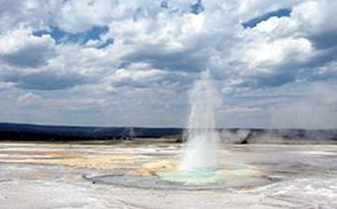
Clepsydra
geyser at play, Lower Geyser basin.
Yellowstone
is world-famous for its natural heritage and beauty - and for the fact that it
holds half the world's geothermal features, with more than 10,000 examples.
Travelers to Yellowstone can view more than 300 geysers (such as 'Old
Faithful'), pools of boiling mud, and an amazing assemblage of wildlife,
such as grizzly bears, wolves, bison and elk, all while standing on the surface
of the Earth's largest known 'super-volcano'.
Mammoth
- Mammoth Hot Springs. Mineral-laden hot water flows from
springs, depositing calcite and other substances in its wake. Over time, these
deposits form large terraces and other shapes. Some of the terraces grow
several inches per day.
- Fort Yellowstone. The historic center of activity during
the United States Army's tenure of the park.
- Bunsen Peak. The hike to the top of this 8,564 foot peak takes
approximately three hours round trip. The peak overlooks the old Ft.
Yellowstone area and it is only a gradual climb. Bring water and snacks
(and bear bells if you think they'll work).
Norris
- Norris Geyser Basin. One of the parks many spectacular thermal
areas, and home to Steamboat Geyser, the world's largest geyser, which can
throw water more than 300 feet into the air when it erupts. The Norris
area is the hottest, most acidic, and most changeable in the park.
- Roaring Mountain. A collection of steam vents and hot
springs which make noises ranging from a nearly inaudible whisper to a
roar that can be heard miles away. This thermal feature is right beside
the park highway.
- Gibbon River
- Virginia Cascades
Mdison
- Artist Paint Pots. A half-mile hike takes you past many
colorful hot springs, steam vents and bubbling mud pots.
- Monument Geyser Basin
- Gibbon Falls. These 84-foot falls tumble down a
staircase-like rock -- easy to see from a pullover area on the park
highway.
- Madison River. The river creates a canyon with steep,
tree-covered rock walls on each side.
- Terrace Springs
- Firehole Canyon Drive and Firehole Falls
- National Park Mountain. The mountain where the Madison and
Firehole rivers meet. As legend has it, this is where the idea came about
to preserve Yellowstone as a National Park.
Geyser
basins, including Old Faithful
- Upper Geyser Basin. The most popular visitor area in the
park, the Upper Geyser Basin is home to the largest number of geysers in
the park, with over 100 located within a one square mile area. Boardwalks
allow access to the most interesting areas. Do not leave the trails;
the surface here is thin and unstable and has a real chance of depositing
you in a boiling pool of water if you walk where you're not supposed to
- Old Faithful The world's most famous geyser,
with large eruptions occurring an average of about once every hour and a
half. Despite its reputation for having eruptions you can set a watch to,
the timing between each eruption has actually been increasing over the
past several decades. Rangers are able to predict the geyser's eruptions
to within about 10 minutes, provided the duration of the previous
eruption is known.
- Other
geysers in Upper Geyser Basin that are well enough understood to be
predictable (sort of!) are Grand
Geyser (probably the finest predictable geyser in the park), Castle Geyser, Daisy Geyser, and Riverside Geyser. Check at the
Old Faithful visitor center for predictions, which will have
uncertainties of an hour or so associated with them, sometimes more.
- Lower Geyser Basin. Unlike Upper Basin, most active areas
here are accessible by car. Great
Fountain Geyser is the largest geyser in this group, is easily
reached by car, and is well enough understood to be predicted, after a
fashion; check at the Old Faithful visitor center, and when you get to the
geyser, check the bulletin board again, as its behavior allows periodic
updating of the predictions.
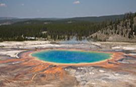
The
Grand Prismatic Spring, viewed from above. There is a trail that goes around
the back of the spring which has a small turn-off that lets intrepid climbers
rise about 400 feet above the spring, and capture the entire basin in one view.
For a closer view, there are raised boardwalks around the spring and nearby
pools (viewable in the detail of the picture)
- Midway Geyser Basin. This geyser basin is on a hill
overlooking the Firehole River. The runoff from its thermal features flows
into the river, leaving steaming, colorful trails in its wake. Absolutely
spectacular!
- Grand Prismatic Spring. Perhaps
this geyser basin's most famous feature, this is a mass of sapphire blue
hot water with bands of yellow and orange around its edges. This spring
is more than 300 feet across.
- Excelsior Geyser once had such violent eruptions
that it seems to have blown itself up. This geyser hasn't erupted in
years, but it still discharges over 4000 gallons of water per minute into
the nearby Firehole River.
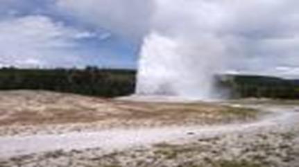
Geyser
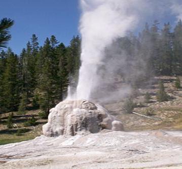
Lone
Star geyser erupting, Check at Old Faithful Visitor Center for times
- Lone Star Geyser Basin. This and the following are more
'Do' than 'See,' as they require some hiking to reach
them. The route takes off from the loop road south of Upper Geyser Basin
and follows an old, now-closed road for a total of about 3 miles (5 km).
Bicycles can make it most of the way to Lone Star. Nice hike for families.
- Shoshone Geyser Basin. Serious hiking is required to reach this
remote basin, which is beyond Lone Star and a good 7 miles (12 km) one way
from the trailhead.
Grant
Village
- West Thumb Geyser Basin. With a little imagination, Yellowstone
Lake looks like a left hand reaching southward. This thermal area is along
the western thumblike section of the lake. Several geysers and hot springs
(even a couple that are just a few inches across!) are in this area,
including the following two sights:
- Abyss Pool. There is an optical illusion with
this brilliant blue hot spring that makes it look bottomless.
- Fishing Cone. In the past, people used to catch
fish in Yellowstone Lake and then cook the fish by dipping them into this
partially submerged hot spring. This stunt is no longer allowed.
- Shoshone Lake
Lake
Area
- Yellowstone Lake. This is the largest freshwater lake at an
elevation over 8,000 feet in the country. It spreads 20 miles east to west
and 30 miles north to south. The Yellowstone River empties out into the
lake.
- Mud Volcano/Sulphur Cauldron. This area of the park has pools of
mud that are constantly seething and boiling.
- Mud Volcano This was once a hilltop thermal
feature that would hurl mud into the nearby trees during eruptions. One
particularly large eruption blew apart the Mud Volcano, leaving a hot,
bubbling mud pool at the base of the hill.
- Dragon's Mouth Spring Steam
and hot water surge forth from within an underground cavern, creating
waves in the surface mud pool. These surges of water and steam
reverberate inside the cavern and make loud thumping or roaring sounds.
- Sulphur Cauldron This vast hot spring is strongly
acidic thanks to the action of microorganisms.
- Natural Bridge
Canyon
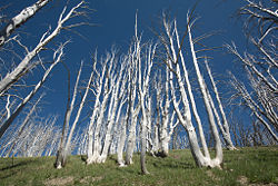
Dead
trees near the summit of Mt. Washburn. These trees are the victims of a massive
forest fire in 1987 that burned through over 30% of the forest running through
the park. In a controversial decision, it went unchecked by the National Park
Service, but has allowed for new growth to sprout in large parts of the park.
- The Grand Canyon of the Yellowstone. Chemical processes over time have
left stripes and patches of different colors in the rock of this canyon.
Depths of the canyon reach 800-1200 feet. Trails lead along the north and
south rims of the canyon, but while traveling the entire trail in one day
is possible, it makes for a long and tiring day. Best to make it two
shorter (~3 hour) day hikes. If you're a photo buff, plan your walks so
the sun illuminates the opposite side for great pictures.
- Artist point - great spot to view the canyon and the
lower falls.
- The Upper and Lower Falls of the Yellowstone. These
are the two largest waterfalls in the park. The Upper Falls is 109 feet
tall and creates a small canyon. The large Lower Falls is about 309 feet
tall, and creates the Grand Canyon of the Yellowstone.
- Hayden Valley. Some people say it's the best place to
watch bison in Yellowstone. Hayden Valley is home to a large number of
animals, and includes the infamous Mud Volcano.
- Mt. Washburn. One of the best places in the park for
spotting bighorn sheep, a trail leads up the mountain to a lookout tower
near the 10,243 foot summit. The altitude may affect some hikers, so it is
best to be acclimatized to the higher elevation before attempting this
hike. In addition, bring extra layers, even in the summer, since the top
can be windy and cold.
Tower-Roosevelt
- Specimen Ridge
- Petrified Forest. This is home to a large petrified forest.
It is accessible along the highway.
- Tower Fall. The 100-foot tall waterfall plunges down a rock,
creates a thin canyon, and a rapid creek.
- Calcite Springs
10.Do
- Young
Scientist Students
ages 5 and up can learn about Yellowstone's geothermal features. Students
are given scientist toolkit, including an infrared thermometer, stop
watch, magnifying glass and other gear. Once you've finished it, you have
a choice of a patch or key chain
- Jr Ranger
Program Jr
Ranger Program provides an opportunity for children 5 - 12 to earn a Jr
Ranger patch. Ages 5-7 can earn the wolf patch and Ages 8-12 can earn the
Bear patch. In order to get a patch, a 12 page activity booklet needs to
be answered correctly and checked by a ranger. An activity booklet costs
$3.
Many
visitors believe they can visit all 2.2 million acres of Yellowstone in
1-2 days - all the while staying within sight of their car or tour bus. To
truly appreciate this vast park, get off the park roads and paved tourist
paths.
- Hiking -- Walking as little as 100 feet away from the camera
gangs will give you more of an appreciation for the park. Taking a few 3-4
hour day hikes on established hiking trails is even better, yet will still
allow you the luxury of a hot shower in the morning and prepared dinner in
the evening.
- Wildlife Viewing -- There is a lot of wildlife to view
within the park limits. Birds (osprey, bald eagles, and many, many other
species,) bison, big cats, deer, wolves, fox, bears, big-horn sheep, elk,
and other animals can all be seen within the park over a short period of
time. The more time that you spend in the park, the more wildlife that you
will see. Some animals, such as the wolves, bears, and the big-horn sheep
are generally not viewable from the park roads. The spaces within the park
are grand, so make sure to bring binoculars and/or a spotting scope to
best view animals safely.
- Horseback Riding -- There are many opporunities to enjoy
YNP and the scenery there. Endulge in horse riding opportunities in YNP
and a famous battlefield.
- Backpacking
- Photography -- Yellowstone holds unprecedented photo opportunities
with natural environments, beautiful hydrothermal features and animals to
be found throughout the park. The colors of the hot springs range from
bland white (for the very, very hot) to yellows and blues, greens and
oranges. Some of the features are very large, and the challenge can be
finding a way to get them in the frame. Be creative! There have been a lot
of pictures taken in Yellowstone, and there are a lot more still waiting
to be taken.
- Fishing
- Swimming -- Swimming is allowed (but not encouraged) at the
Firehole Cascades swimming area, a section of the Firehole River that is
warmed by hot springs. This area, accessible via the Firehole Canyon
Drive, has a toilet but no lifeguard and not much parking.
- Interpretive Programs
11.Buy
Every
major village within the park offers food, camping supplies, and souvenirs for
sale, although these stores all close during the winter months.
Gasoline and automotive services are available in
the following locations:
- Canyon (late April to early November). Gasoline, diesel and
auto repair.
- Fishing Bridge (mid May to late September). Gasoline,
diesel, propane and auto repair.
- Grant Village (mid April to mid October). Gasoline, diesel,
propane, and auto repair.
- Mammoth (early May to mid October). Gasoline and diesel.
- Old Faithful (Lower) (mid April to early November). Gasoline
and diesel.
- Old Faithful (Upper) (late May to late September). Gasoline and
auto repair.
- Tower Junction (early June to early September). Gasoline.
12.Eat
Most
of the villages sell food supplies and may offer snack bars. The following
restaurants and cafeterias are also available:
- Old Faithful Inn Dining Room
- Old Faithful Snow Lodge Restaurant
- Old Faithful Lodge Cafeteria
- Lake Yellowstone Hotel Dining Room
- Lake Lodge Cafeteria
- Grant Village Restaurant
- Grant Village Lakehouse Restaurant
- Canyon Lodge Cafeteria. Great breakfast with omelet of the day
($4.2), links ($1.05 for two), bacon ($1.05 for two), hot oatmeal and a
few other choices.
- Canyon Lodge Dining Room
- Mammoth Hot Springs Hotel Dining Room
- Roosevelt Lodge Dining Room
13.Drink
Cocktails
can be purchased in the lodge restaurants, and lighter beverages can be
obtained at the snack bars.
14.Sleep
Lodging
Reservations
for all lodges and cabins in the park can be made through www.travelyellowstone.com
or by calling (307) 344-7311. All park accommodations are non-smoking and,
reflecting the natural surroundings of Yellowstone, televisions, radios, air
conditioning, and Internet hook-ups are not available.
- Canyon Lodges,. Includes Canyon Lodge, Cascade Lodge,
and Dunraven Lodge. Canyon lodge has cabins with double beds with private
bath. It easily accommodates 4 adults.
- Canyon Frontier / Pioneer Cabins
- Canyon Western Cabins
- Grant Village,. Offering an array of hotel-like rooms
and cabins for families, this hotel complex provides the basic amenities without
some of the flair of the Old
Faithful Inn but at prices that are a bit lower, and Grant villiage
may have greater availability due to the number of rooms available there.
There is a post office nearby, as well as a cafeteria, a soda-jerk diner,
and a sandwich shop in the complex, as well as a reservations-only
restaurant serving local fare. Even if you decide not to eat at the
restaurant, do go in to check out the large array of beautiful photographs
taken by one of the long-time Yellowstone Maintenance heads, who is also
one of the park photographers.
- Lake Yellowstone Hotel & Cabins,. Located right on Lake Yellowstone
(there's a boat pier and a restaurant right on the edge of the lake), the
Lake Yellowstone Hotel and Cabins provide a rustic experience that
probably won't excite a luxury traveler, but the staff provides the basics
- decent rooms, reasonably good food, and breathtaking views of the lake
and its surroundings. Watch out for mosquitos especially as you walk near
the lake in mornings and afternoons in the summer, they come out in
swarms, but DEET or similar mosquito repellant will keep them away.
- Lake Lodge Cabins
- Mammoth Hot Springs Hotel & Cabins
- Old Faithful Inn,. Historic, rustic style hotel with vast
lobby, incorporating large tree trunks as pillars and a stone fireplace.
Range of accommodations from rooms with shared bathrooms and showers
nearby, to suites with private bathrooms and refrigerators. Located near
Old Faithful Geyser. Open July-mid Sep.
- Old Faithful Lodge Cabins,. Large windows in the lobby face
Old Faithful Geyser. Gift shop, restaurants, bakery. Open from May-Oct.
- Old Faithful Snow Lodge,. Open May-Oct.
- Roosevelt Lodge Cabins
Camping
Xanterra
Parks & Resorts operates campgrounds at Bridge Bay, Canyon,
Fishing Bridge, Grant Village, and Madison. Same-day reservations can be made
by calling: 307-344-7901. Future reservations can be made by calling:
307-344-7311 or by writing: Yellowstone National Park Lodges, PO Box 165,
Yellowstone National Park, WY 82190.
Reservations
should be made well in advance and/or campsites should be secured as early in
the day as possible. Campgrounds may fill by early morning, especially during
peak season (early July - late August). Recreational vehicles over 30 ft should
make reservations since there is a limited number of RV sites available in
Yellowstone. Large RV sites are located at Flag Ranch, Fishing Bridge RV Park
and West Yellowstone.
Indian
Creek, Lewis Lake, Mammoth, Norris, Pebble Creek, Slough Creek, and Tower Fall
are operated by the National Park Service and do not accept reservations; all
sites are first-come, first-served.
- Bridge Bay (27-May to 18-Sep). 432 sites, flush toilets, RV dump
station, $17 per site.
- Canyon (06-Jun to 11-Sep). 272 sites, showers, flush toilets,
$20.15 per site.
- Fishing Bridge RV (20-May to 02-Oct). 344 sites, showers,
flush toilets, RV sewer station, $31 per site. This is the only campground
offering water, sewer, and electrical hookups, and it is for hard-sided
vehicles only (no tents or tent-trailers are allowed).
- Grant
(21-Jun to 02-Oct). 425 sites, showers, flush toilets, RV dump station,
$19 per site.
- Indian Creek (10-Jun to 19-Sep). 75 sites, pit toilets, $12 per site.
- Lewis Lake (17-Jun to 06-Nov). 85 sites, pit toilets, $12 per site.
- Madison (06-May to 30-Oct). 277 sites, flush toilets, RV dump
station, $17 per site.
- Mammoth (Year round). 85 sites, flush toilets, $14 per site.
- Norris (20-May to 26-Sep). 116 sites, flush toilets, $14 per
site.
- Pebble Creek (03-Jun to 26-Sep). 32 sites, pit toilets, $12 per site.
- Slough Creek (27-May to 31-Oct). 29 sites, pit toilets, $12 per site.
- Tower Fall (20-May to 26-Sep). 32 sites, pit toilets, $12 per site.
Backcountry
Permits
are required for all backcountry camping, and quotas are placed on the number
of people that may use an area at a given time. The maximum stay per
backcountry campsite varies from 1 to 3 nights per trip. Campfires are
permitted only in established fire pits, and wood fires are not allowed in some
backcountry campsites. A food storage pole is provided at most designated
campsites so that food and attractants may be secured from bears. Neither
hunting nor firearms are allowed in Yellowstone's backcountry.
Permits
may be obtained only in person and no more than 48 hours in advance of your
trip, although backcountry sites may be reserved through the mail well in
advance for a non-refundable $20 reservation fee. To reserve a site, download
the reservation form from the Backcountry
Trip Planner, call (307) 344-2160, or by writing: Backcountry
Office, PO Box 168, Yellowstone National Park, WY 82190.
During
the summer season (Jun-Aug), permits are available 7 days a week between 8AM
and 4:30PM at the following locations:
- Bechler
Ranger Station
- Canyon
Ranger Station/Visitor Center
- Grant Village
Visitor Center
- Lake
Ranger Station
- Mammoth
Ranger Station/Visitor Center
- Old
Faithful Ranger Station
- South
Entrance Ranger Station
- Tower
Ranger Station
- West
Entrance Ranger Station
In
addition, permits may sometimes be obtained from rangers on duty at the East
Entrance and Bridge Bay Ranger Station. However, these rangers have other
duties and may not be available to provide assistance at all times.
During
the spring, fall, and winter seasons, ranger stations and visitor centers do
not have set hours. To obtain a Backcountry Use Permit during these seasons,
check the office hours posted at the nearest ranger station or visitor center.
15.Stay safe
Though
many of the animals in the park are used to seeing humans, the wildlife is
nonetheless wild and should not be fed or disturbed. Stay at least 100 m away from bears and 25 m from all other wild animals!
Bison, elk, moose, bears, and nearly all large animals can attack! For any
doubters, the National Park Service has put a series of animal attack videos
online -- these animals are large, wild, and potentially dangerous, so give
them their space.
In
addition, be aware that odors attract bears and other wildlife, so avoid
carrying or cooking odorous foods and keep a clean camp; do not cook or store
food in your tent. All food, garbage, or other odorous items used for preparing
or cooking food must be secured from bears. Treat all odorous products such as
soap, deodorant, or other toiletries in the same manner as food. Do not leave
packs containing food unattended, even for a few minutes. Animals which obtain
human food often become aggressive and dependent on human foods, and many can
suffer ill health or death from eating a non-native diet.
When
camping, either filter, boil, or otherwise purify drinking water. Waters may be
polluted by animal and/or human wastes, and intestinal infections from drinking
untreated water are increasingly common.
Always
stay on boardwalks in thermal areas. Scalding water lies under thin, breakable
crusts; pools are near or above boiling temperatures. Every year visitors
traveling off trail are seriously burned, and people have died from the
scalding water. No swimming or bathing is allowed in thermal pools.
The
weather can change rapidly and with little warning. A sunny, warm day can
quickly become a cold, rainy or even snowy experience. Hypothermia can be a
concern. Be prepared for a variety of weather conditions by bringing along
appropriate clothing. Lightning can and does injure and kill people in the
park, so watch the sky and take shelter in a building if you hear thunder.
Conclusion
As you can see The United States of America is a
beautiful country which has to offer a lot of beautiful places rich in superb
landscapes and nice places to camp or hike . Everyone in this world should have
the privilege to visit at least one of the many national parks that U.S.A has
on it's territory .
I
really hope that sooner or later I will have the chance to visit one of
American's National Parks to see it's splendour and to see with my very eyes
everything that I have found out while writing this paper.
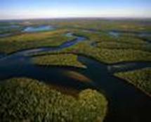
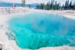
Everglades Yellowstone
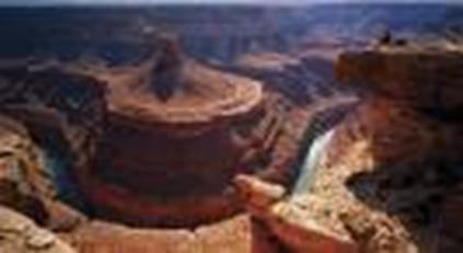
Grand canyon
BIBLIOGRAPHY
v
www.wikipedia .com


