| CATEGORII DOCUMENTE |
| Bulgara | Ceha slovaca | Croata | Engleza | Estona | Finlandeza | Franceza |
| Germana | Italiana | Letona | Lituaniana | Maghiara | Olandeza | Poloneza |
| Sarba | Slovena | Spaniola | Suedeza | Turca | Ucraineana |
DOCUMENTE SIMILARE |
|
Funciones básicas del sistema AutoMapa
AutoMapa puesta en marcha
Después de la primera puesta en marcha, la pantalla mostrará una pantalla de selección de idioma para la interfaz AutoMapa (la pantalla se visualiza sólo si más idiomas se han instalado).
Entonces la 'Advertencia' pantalla, que contiene información e instrucciones en materia de seguridad de uso durante la conducción. Después de leer su contenido, toque el botón Aceptar situado en la esquina inferior derecha de la pantalla para continuar. Para desactivar la visualización del mensaje en la próxima puesta en marcha, comprobar el 'No volver a mostrar este nuevo' cuadro en la esquina inferior izquierda de la pantalla.
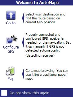
La pantalla mostrará una pantalla de bienvenida con un acceso rápido a las opciones seleccionadas AutoMapa.
Ir a - abre un menú de selección de destino que le permite comenzar de inmediato a la navegación en la dirección dada: después de elegir un destino, AutoMapa se encuentra una ruta basada en la posición GPS actual.
La navegación requiere una característica correctamente conectado y configurado el receptor GPS. Por lo general, la puesta en marcha se realiza automáticamente. Si la señal del GPS no está activo, seleccione Configurar el GPS y ajustar los valores de la aplicación para adaptarse a la configuración de su receptor GPS.
Mapa - Seleccione para ir al modo básico de funcionamiento AutoMapa, es decir, mapa de navegación. Esta opción ofrece la mejor introducción a la solicitud, y, como tal, se recomienda para los nuevos usuarios.
 Para
desactivar la visualización de la pantalla de bienvenida en cada puesta en
marcha, comprobar el 'No volver a mostrar este nuevo'.
Para
desactivar la visualización de la pantalla de bienvenida en cada puesta en
marcha, comprobar el 'No volver a mostrar este nuevo'.
Simplificado y de expertos menú
Por defecto, AutoMapa se ejecuta en modo de interfaz simplificada con acceso sólo a las más importantes del sistema opciones. Para activar el modo experto, seleccione la opción 'menú de expertos' desde el menú principal de la solicitud.
Las diferencias entre los dos modos consisten en la aparición de la barra de sistema y el número de opciones disponibles en el menú principal, vía menú, y 'Mostrar posición' del menú.
Mapa botones
En el modo simplificado, el sistema de barras se reduce a tres (por lo general, los dos primeros) botones en la parte inferior del mapa que aparece.
|
|
el botón en la esquina inferior izquierda de la pantalla se abre el menú principal. |
|
|
el botón en la esquina inferior derecha se abre el menú contextual de un determinado punto del mapa. |
|
|
disponible sólo si la posición GPS es que no se muestran y restablece la posición de visualización. |
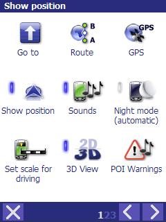
Menú principal
El menú principal presenta las opciones clave para el funcionamiento del sistema AutoMapa. Algunas opciones están marcadas por un pequeño rectángulo de la izquierda, que se asemeja a un diodo de luz. Cuando gris, el rectángulo indica que dada la opción no está activa en este momento. Cuando el rectángulo se enciende de color azul, dada la opción está activa.
El menú cuenta con dos pantallas - puede mover entre ellas con el uso de <y> botones de la barra en la parte inferior de la pantalla. Pulse el botón X para salir del menú.
Otras opciones del menú principal:
|
|
Abre la 'Ir a' menú, como se comenta en el '» Ir a la «menú y buscar objetos' capítulo. |
|
|
Abre la 'ruta' del menú, donde el usuario puede realizar operaciones en la ruta asignada y cambiar el tipo de ruta. |
|
|
Navegar / Mostrar posición - desactiva y restaura la pantalla de su posición actual en el mapa, el GPS tiene que estar activa (activada por defecto). |
|
|
Computer - abre el ordenador de bordo en el panel de pantalla, que muestra la información viaja a la velocidad, distancia, parada y el tiempo de conducción, etc Para más información se refieren a la 'Mostrar posición' capítulo. |
|
|
Sonidos - se activa y desactiva todos los sonidos AutoMapa, la opción de hacer clic sonidos, mensajes de navegación, etc Siempre es activa cuando la aplicación se inicia. Opciones de los mensajes: se refieren a la 'Configuración' capítulo. |
|
|
Mostrar PDI - permite al usuario definir la categoría de la muestra de PI; se refieren al 'Mapa de puntos' capítulo. |
|
|
Piloto - se activa y desactiva el panel piloto (información sobre las maniobras y la ruta) durante la navegación. Por defecto, el piloto se activa automáticamente cuando se activa la navegación, y se desactiva la navegación cuando está apagado. Consulte la 'navegación' capítulo. |
|
|
Vista 3D - se activa y desactiva la vista de mapa 3D. De forma predeterminada, el modo 3D se activa automáticamente cuando se activa la navegación, y se desactiva la navegación cuando está apagado. Consulte la 'navegación' capítulo. |
|
|
Advertencias PDI - permite al usuario establecer parámetros de alerta PI; referirse a la 'Mostrar posición' capítulo. |
|
|
Fin - cierra el programa. Esta función puede ser asignada a un botón de hardware (consulte la sección 'botones de hardware'). |
|
|
Sobre el programa - muestra información sobre la versión del programa, sus productores, la carga de ruta y datos de licencia propietaria. |
|
|
Expertos menú - se activa la interfaz de modo completo (el modo experto). |
|
|
Configuración - abre el menú de configuración. Consulte la 'Configuración' capítulo. |
AutoMapa puede operarse en tres modos:
la vista de mapa modo - con el receptor GPS fuera,
mostrar la posición y el modo de seguimiento - con el receptor GPS en una, pero sin mapas de ruta,
el modo de navegación - con el receptor GPS y una ruta asignada.
Vista de mapa
Esta es la forma más sencilla de trabajar con AutoMapa y no requiere una conexión con el receptor GPS. En este modo, el usuario puede ver el mapa, encontrar la dirección o puntos de PI. El usuario puede también asignar una ruta entre los puntos seleccionados y ver la ruta en el mapa.
Cuando el usuario grifos en cualquier punto en el mapa o un icono de un objeto que aparece en el mapa, un 'globo' con una descripción de una ubicación determinada se mostrará: el nombre de la calle y la ciudad, la construcción de la dirección, descripción del PDI o un punto favorito.
AutoMapa permite al usuario encontrar la ubicación de búsqueda de varias maneras.
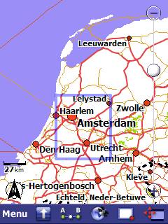
Uno de ellos implica el uso de herramientas para el desplazamiento del mapa y el cambio de la escala en que el mapa se muestra. Este es un buen método: si el usuario sabe en qué zona del mapa el punto buscado se encuentra, y los nombres de lugares no tienen que ser inscritos en la ventana de búsqueda.
Dos funciones son especialmente útiles en el proceso de búsqueda: el 'grabber' (mapa de desplazamiento) y 'zoom' (aumento de un mapa). La función de zoom no está disponible en la versión de interfaz simplificado.
El grabber mano - Mapa del desplazamiento
![]() El mapa muestra la sección se puede
cambiar al mover el mapa o magnificar un fragmento seleccionado. Si el 'grabber mano' icono se
muestra en la esquina inferior derecha de la pantalla, AutoMapa trabaja en el
modo de desplazamiento - cada movimiento de la herramienta de pan / dedo en la
pantalla se mueve el mapa en la dirección indicada. La
escala en el mapa que se muestra no es cambiado.
El mapa muestra la sección se puede
cambiar al mover el mapa o magnificar un fragmento seleccionado. Si el 'grabber mano' icono se
muestra en la esquina inferior derecha de la pantalla, AutoMapa trabaja en el
modo de desplazamiento - cada movimiento de la herramienta de pan / dedo en la
pantalla se mueve el mapa en la dirección indicada. La
escala en el mapa que se muestra no es cambiado.
Zoom - la ampliación de los fragmentos del mapa (modo experto)
![]() Use la herramienta de zoom para ampliar una sección
del mapa. Toque en el 'grabber mano'
icono, que será sustituido por el 'zoom' icono, y AutoMapa cambiará
al modo de zoom. Cuando dentro de un rectángulo se dibuja en la pantalla, el
fragmento seleccionado del mapa se ampliará a pantalla completa.
Use la herramienta de zoom para ampliar una sección
del mapa. Toque en el 'grabber mano'
icono, que será sustituido por el 'zoom' icono, y AutoMapa cambiará
al modo de zoom. Cuando dentro de un rectángulo se dibuja en la pantalla, el
fragmento seleccionado del mapa se ampliará a pantalla completa.
 Para volver al modo de desplazamiento, toque en el
'zoom' icono (que será sustituido por el 'grabber mano'
icono).
Para volver al modo de desplazamiento, toque en el
'zoom' icono (que será sustituido por el 'grabber mano'
icono).
Cuando el desplazamiento del mapa, puede cambiar la escala para adaptarla a las necesidades propias. Mapa escala también puede ser modificado con la escala regla de cálculo.
Escala regla de cálculo
La escala regla de cálculo se encuentra a la derecha de la pantalla AutoMapa. Se utiliza para ampliar sin problemas dentro y fuera del mapa. Si la regla de cálculo se mueve en la dirección del signo '+', el mapa se ampliará para obtener una vista detallada.
Cuando la regla de cálculo se mueve en la dirección del '-', que produce el efecto contrario - el usuario zooms y detalles desaparecen. La regla de cálculo o en un zoom sobre el mapa en referencia al punto de navegación / posición del cursor, que está marcado en el mapa con el 'visor' símbolo. La ubicación del punto de navegación / posición del cursor puede cambiarse por la grabación en un punto seleccionado en el mapa.
Nota: el modo 3D se desactivará automáticamente en mayor escala de valores.
Gobernante
La regla que indica la distancia real entre los puntos en el mapa se encuentra en la esquina inferior izquierda de la pantalla AutoMapa. El gobernante se muestra el campo de distancia (en metros o kilómetros) está representada por el mapa a la escala actual. La distancia que aparece corresponde a la duración de toda la regla y no la duración de su sección.
Compass
La brújula se muestra en la esquina inferior izquierda de la pantalla como una flecha con la letra 'N', apuntando hacia el norte.
Pulsando sobre la brújula, se suman la parte superior del mapa hacia el norte.
Flecha direccional a punto de ruta
La flecha se muestra en la esquina superior izquierda de la pantalla y muestra la dirección hacia el próximo punto de la ruta (esta función está oculta por defecto).
La característica más arriba pueden ser ocultas o mostradas en la interfaz de configuración en el menú de ajustes.
Un punto en el mapa se puede seleccionar de varias maneras:
mediante la celebración de su dedo
o la herramienta pan en un determinado punto del mapa, ![]()
tocando en el 'Mapa del cursor' icono de la barra de herramientas abajo del mapa (a menos que una función diferente se le ha asignado a esta opción, consulte la sección 'Hardware claves'),
tocando en el 'Mapa del
punto' en la opción 'Ir a' menú, ![]()
pulsando la tecla respectivos equipos - si esta función ha sido previamente asignados a la clave (se refieren a 'las llaves de hardware').
Al seleccionar un punto en el mapa, se abrirá el menú contextual. Puede asignar una función para el punto seleccionado. El mismo menú se abre cuando un objeto está seleccionado en las opciones para buscar la dirección, PDI, etc en la 'Ir a' menú.
Menú contextual
 El menú
contextual puede abarcar varias páginas y el usuario puede desplazarse entre
las páginas con el uso de <y> botones. Su contenido varía sujeto al contexto,
es decir, el tipo de objeto para el que el menú contextual se abre.
El menú
contextual puede abarcar varias páginas y el usuario puede desplazarse entre
las páginas con el uso de <y> botones. Su contenido varía sujeto al contexto,
es decir, el tipo de objeto para el que el menú contextual se abre.
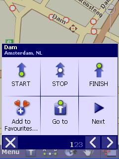
La primera página contiene las opciones de mapas de ruta. El usuario puede activar la navegación a un determinado punto y mapa de la ruta entre los usuarios actuales de la posición GPS y el punto seleccionado Ir a') o puede definir un lugar determinado como uno de los puntos de ruta (punto de inicio - 'START', punto final - 'Finalizar', o una ruta punto - 'STOP').
Si la 'Ir a' opción está seleccionada cuando el receptor GPS está desactivada, el receptor GPS se activará y se hará un intento para determinar la responsabilidad del usuario la posición actual.
La segunda página del menú contextual permite al usuario definir una ubicación seleccionada como Página de inicio, PDI o favoritos Point. Para obtener más información, consulte el 'Mapa de puntos' capítulo.
La 'Mostrar coordenadas' opción se mostrará en detalle el GPS coordenadas del punto seleccionado en el mapa.
En caso de que un tramo de carretera se ha seleccionado en el mapa, el 'Bloque de la sección de' opción de prohibir el tráfico a lo largo de esa ruta, y que el artículo se evitarán cuando la ruta está asignada. Si la sección ya estaba bloqueado, puede ser desbloqueado. Para obtener más información, consulte la 'Hoja de bloques' capítulo.
Si un favorito o un punto POI definido por el usuario está seleccionado, el punto se puede mover el cursor sobre el mapa, borrados o copiados con el uso de 'Copy / Cut / Eliminar / Pegar' opciones.
 La forma más rápida de encontrar un
determinado objeto en el mapa (por ejemplo, la calle, restaurante) es
introducir su nombre en la ventana de búsqueda en el 'Ir al' menú.
La forma más rápida de encontrar un
determinado objeto en el mapa (por ejemplo, la calle, restaurante) es
introducir su nombre en la ventana de búsqueda en el 'Ir al' menú.
|
|
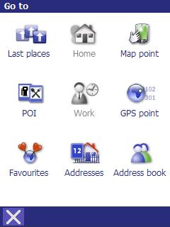
El menú se puede abrir con un toque a la 'Ir a' icono de la barra de herramientas o en el menú principal. |
Están disponibles las siguientes opciones:
Inicio / Trabajo - abre la navegación a los puntos marcados en el mapa. Si esta opción está en gris, los puntos no se han marcado. Marcar los puntos de la selección de un lugar determinado en el mapa con el uso de 'Ir a' las opciones de menú, por ejemplo, introduciendo una dirección.
Direcciones - permite al usuario seleccionar una dirección en una ciudad cubierta por el mapa (consulte la sección 'Búsqueda de dirección').
PDI - permite al usuario buscar un PDI de la base de datos de los puntos incorporados en el mapa o definidos por el usuario (consulte la sección 'Búsqueda de POI').
Favorito puntos - es una lista de los definidos por el usuario, favorito puntos - la más utilizada puntos.
GPS punto - permite al usuario entrar en el punto del GPS coordina.
Mapa punto - se abre el menú contextual de la situación actual en el mapa.
Última lugares - proporciona al usuario un acceso rápido a la lista de puntos / objetos que recientemente han sido objeto de búsqueda / seleccionados en el mapa.
Libreta de direcciones - permite al usuario seleccionar una dirección de Windows Mobile la libreta de direcciones. No es activa en un PC.
Buscar dirección
 Por defecto, la búsqueda se lleva a cabo en el país del usuario actual
posición (GPS posición o posición del cursor en el mapa). En situaciones poco claras (por ejemplo, cuando
el cursor se coloca fuera del territorio de cualquier país), el programa le
preguntará al usuario seleccionar el país en primer lugar, a condición de que
los mapas de varios países se han instalado en el
dispositivo.
Por defecto, la búsqueda se lleva a cabo en el país del usuario actual
posición (GPS posición o posición del cursor en el mapa). En situaciones poco claras (por ejemplo, cuando
el cursor se coloca fuera del territorio de cualquier país), el programa le
preguntará al usuario seleccionar el país en primer lugar, a condición de que
los mapas de varios países se han instalado en el
dispositivo.
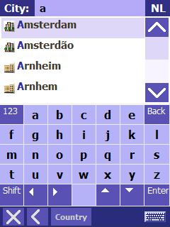
El proceso de búsqueda comienza con introducir el nombre de la ciudad. El usuario tiene que introducir las primeras letras de la ciudad o en el nombre de 'Ciudad:' sobre el terreno en la parte superior de la pantalla. El código del país en que la dirección se busca es que aparece en la esquina superior derecha de la pantalla. Para cambiar el país, utiliza el 'País' opción en la barra situada en la parte inferior de la pantalla.
Cuando el usuario toques de uno de los lugares encontrados por AutoMapa, el programa mostrará la ventana de búsqueda de la calle dada en la ciudad.
Cómo buscar y sugerir automática de la lista de las ciudades y encontrar calles comienza después del segundo carácter es introducido. También hay una demora adicional, lo que permite al usuario introducir rápidamente varios caracteres.
Si los resultados de la búsqueda encajar una sola pantalla, el teclado se derrumbó automáticamente para facilitar la dirección de selección.
Nota: el programa memoriza los lugares previamente seleccionados, que se propuso durante la posterior búsqueda investiga. En esta situación, el teclado no se abre automáticamente. Para encontrar una dirección en una nueva ubicación, abra el teclado con el icono en la esquina inferior derecha de la pantalla o toque en el campo el lugar donde se introduce el nombre.
Después de encontrar la ubicación, el usuario puede seleccionar como un objeto de interés (en la grabación de su nuevo nombre) o - para encontrar una determinada calle - introducir las primeras letras del nombre de la calle en la 'calle' sobre el terreno.
Después de seleccionar la calle, el usuario puede: seleccionar la calle en su totalidad ( 'Toda la calle'), encontrar la dirección asignada a la calle (introduciendo la dirección en el campo 'Dirección:' o el desplazamiento de la lista), o seleccionar un cruce con otras calles ( 'Mostrar enlaces').
Si las calles no tienen los números de las casas, o si no hay calles en el lugar, la dirección de búsqueda se terminan en la fase anterior.
Al pulsar en una dirección seleccionada punto (o la salida, los 'Toda la calle', o el nombre de la ciudad o en la pantalla anterior), el usuario abra el menú contextual de una ventana en la cual el lugar determinado se puede configurar como un destino punto, un punto de ruta, 'Home', 'trabajo', PDI, favoritos, o se pueden visualizar en el mapa.
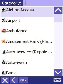 En la ventana de búsqueda POI, el
usuario define en primer lugar la categoría de PI (por ejemplo, Farmacia, ATM,
Restaurante).
En la ventana de búsqueda POI, el
usuario define en primer lugar la categoría de PI (por ejemplo, Farmacia, ATM,
Restaurante).
Los objetos que se encuentran en la misma categoría se muestran en la ventana de búsqueda. The results are listed in the order of the nearest to the most distant objects. Los resultados se resumen en el orden de la más cercana a la mayoría de los objetos distantes. Después de tocar en la descripción o el icono del objeto en la lista de resultados, el usuario tendrá acceso al menú contextual donde el punto dado se pueden ver en el mapa y se pueden añadir, por ejemplo, a la lista de favoritos puntos.
Para encontrar un punto en una ubicación diferente a la ruta, volver al mapa y desplazarse al lugar donde la nueva búsqueda se inicia (al colocar el cursor sobre el mapa).
Para encontrar una PI a un determinado pueblo o ciudad, seleccione el PI con el uso de la 'Ciudad' opción en la barra situada en la parte inferior de la pantalla.
La 'Ver' opción en la pantalla con la lista de puntos permite al usuario:
Cambiar el radio de búsqueda (opciones: 'cercana' y las tres opciones siguientes con el número de kilómetros). El radio de búsqueda se determina por el número de PDI se encuentran en la zona. Cuanto más el sistema de PI se encuentra en la zona, el más restringido el radio de búsqueda.
Filtrar la lista de los encontrados puntos de manera que sólo incorporado o en los puntos definidos por el usuario se muestran los puntos (todos los puntos se muestran por defecto).
Si una ruta ha sido mapeado, la
búsqueda puede limitarse a los puntos en la 'zona' de la ruta con el
uso de la 'Cerca de ruta'. Los iconos que
aparecen por estos puntos indican la distancia: ![]() hasta 50 m,
hasta 50 m, ![]() 100 m,
100 m, ![]() 150 metros de la ruta. El icono de color
gris oscuro
150 metros de la ruta. El icono de color
gris oscuro ![]() significa un punto en el lado de la carretera frente
a la recorrida dirección (es decir, a la izquierda en Europa continental y de
la derecha en Gran Bretaña).
significa un punto en el lado de la carretera frente
a la recorrida dirección (es decir, a la izquierda en Europa continental y de
la derecha en Gran Bretaña).
Mapa de puntos
Puntos favoritos
Favoritos puntos de referencia son un conjunto de usuarios definidos puntos. Ellos pueden ser utilizados para registrar las direcciones de los miembros de la familia, restaurantes favoritos o cualquier otro lugares que visita con frecuencia.
Favoritos son los puntos establecidos en el mapa de apertura el menú contextual en cualquier ubicación en el mapa o objeto encontrado (dirección, PDI, etc) y por la elección de la 'Añadir a favoritos'. La función de agregar un favorito punto también puede ser asignado a una clave de hardware (se refieren a las 'llaves de hardware' capítulo).
Puntos favoritos se muestran en el
mapa de una bandera icono: ![]() .
.
Favorito puntos se pueden mover en el mapa, borrados o copiados con el uso de 'Copy / Cut / Eliminar / Pegar' opciones desde el menú contextual.
El favorito puntos pantalla de edición se encuentra en el menú de ajustes.
Inicio / Trabajo especial favoritos son los puntos, los que se haya asignado propias opciones en la 'Ir a' menú. Cuando el 'Home' o 'trabajo' opción está seleccionada, la navegación se activa directamente - usted no tiene que pasar por el menú contextual.
Al igual que en los puntos favoritos, 'Home' y 'trabajo' de puntos se puede definir de apertura el menú contextual en cualquier ubicación en el mapa o objeto encontrado (dirección, PDI, etc) y por la elección de la 'Marcar como Home' o 'Mark como el trabajo '.
Los puntos tienen sus propios iconos en el mapa: ![]() y
y ![]() ,
,
Los puntos se muestran en la lista de favoritos puntos Volver a | puntos favoritos').
POI (Puntos de Interés)
El mapa contiene una PDI-en base
para todos los países. El PDI base incluye objetos tales como ![]() farmacias,
farmacias, ![]() restaurantes,
restaurantes, ![]() Cajeros automáticos,
Cajeros automáticos, ![]() hoteles, etc Ellos están
marcados en el mapa con los iconos correspondientes a la categoría dada.
hoteles, etc Ellos están
marcados en el mapa con los iconos correspondientes a la categoría dada.
PI mostrar en el mapa
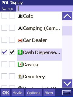 La categoría de puntos para ser visto por el usuario
en el mapa se define con el uso de la 'PI Display' opción en el menú
principal.
Un punto dado categoría se selecciona tocando en las plazas que aparece a la
izquierda del nombre de categoría. Al pulsar en el primero, azul
oscuro cuadrados, el usuario muestra PDI de la categoría determinada, que se
construyen en el mapa.
El segundo, cuadrado negro aparece definido por el usuario, los puntos (la
primera plaza de los definidos por el usuario punto categoría, cuyo nombre
difiere de la categoría estándar, está en gris).
La categoría de puntos para ser visto por el usuario
en el mapa se define con el uso de la 'PI Display' opción en el menú
principal.
Un punto dado categoría se selecciona tocando en las plazas que aparece a la
izquierda del nombre de categoría. Al pulsar en el primero, azul
oscuro cuadrados, el usuario muestra PDI de la categoría determinada, que se
construyen en el mapa.
El segundo, cuadrado negro aparece definido por el usuario, los puntos (la
primera plaza de los definidos por el usuario punto categoría, cuyo nombre
difiere de la categoría estándar, está en gris).
Un parámetro importante es mostrar la escala, por debajo del cual los puntos se muestran en el mapa. La escala se establece con el uso de la 'Escala' botón en la barra de herramientas en la parte inferior de la pantalla. La escala umbral y el número de categorías que aparece debería ser seleccionados cuidadosamente para asegurarse de que los iconos de PI no obstruyan la vista de mapa.
Categorías de PDI se pueden seleccionar y seleccionar con el uso del botón 'Opciones' para mostrar o borrarlos del mapa. El 'Agregar categoría' opción permite al usuario definir una nueva categoría con un nombre personalizado (cuando el icono de alta densidad es superior a escala del mapa los valores, el sistema filtra automáticamente los iconos y no muestra todos ellos).
La 'Ver' botón permite al usuario limitar la lista de las categorías a punto de categorías, que son o no está representada en el mapa.
Cuando el PDI se muestran en el mapa, usted puede obtener más información turística sobre el punto de interés seleccionado, por ejemplo, un showplace, seleccionando la opción 'Información' en el menú emergente.
Agregando PDI
Puntos de interés se fijan en el mapa de apertura el menú contextual en cualquier lugar en el mapa o objeto encontrado (dirección, PDI, etc) y por la elección de la 'Añadir a PI'. Esta función también puede ser asignado a una clave de hardware (se refieren a las 'llaves de hardware' capítulo).
Para añadir PDI, primero seleccione la categoría y el nombre de PI. También puede añadir una breve descripción. El nuevo PI se identificó en el mapa con el mismo icono, que se utiliza para marcar otros puntos de la misma categoría.
PI pantalla de edición
El usuario puede también editar y borrar PDI o importarlos en formato de archivo de AutoMapa otros usuarios o servidores de Internet (por ejemplo, miplo.pl). Esto se puede hacer con el uso del 'usuario de PI' pantalla en el menú de configuración.
Usuario iconos
Puntos de usuario definidos
categorías están marcadas en el mapa con el siguiente icono ![]() .
.
Para asignar un icono de usuario o modificar los iconos de los actuales puntos (incluidos los incorporados en los puntos), usted necesitará un 16 x 16 píxeles de mapa de bits en formato BMP, con un 8-bit color paleta. El nombre del archivo tiene que ser idéntico al nombre de la categoría punto dado. Copie el archivo a la 'Iconos' carpeta en el directorio de instalación AutoMapa.
|
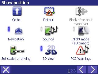
Mostrar posición
|
Sistema de diseño y operación en el modo de mostrar la posición
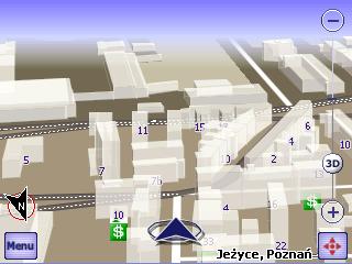
Cuando la posición GPS se ha establecido, AutoMapa cambia automáticamente para mostrar la posición GPS modo - la situación actual es que aparece continuamente en el mapa como una flecha palpitante en un círculo. El mapa gira automáticamente para mostrar el área más grande posible en la dirección viajó, y la del usuario posición actual se muestra en la parte inferior de la pantalla. De forma predeterminada, el modo de pantalla completa (en la interfaz de modo pleno) y la vista de mapa 3D modo se activan. Después de un corto periodo de tiempo, el modo nocturno puede ser activado automáticamente si la señal GPS recibida indica tiempo pasado del sol.
El icono para el desplazamiento y aumento el mapa desaparece de la barra de sistema y es reemplazado por el día y la noche iconos para cambiar a día y modo nocturno.
Al mover un dedo por la pantalla, el usuario interrumpe el modo de mostrar la posición, y este modo se restaurará automáticamente unos segundos después del último movimiento del dedo en el mapa.
Un solo toque en la pantalla se abre la 'Mostrar posición' pop-up menú.
'Mostrar posición' pop-up menú
 Cuando
AutoMapa opera en el espectáculo posición GPS modo, el usuario puede abrir el
menú emergente de tocar la pantalla. Si no se realizan operaciones por el usuario en el curso de
varios segundos, el menú se cerrará automáticamente para proteger la pantalla
contra accidental tocar.
Cuando
AutoMapa opera en el espectáculo posición GPS modo, el usuario puede abrir el
menú emergente de tocar la pantalla. Si no se realizan operaciones por el usuario en el curso de
varios segundos, el menú se cerrará automáticamente para proteger la pantalla
contra accidental tocar.
La 'Mostrar posición' en la primera pantalla permite al usuario apagar el modo de mostrar la posición. Para restablecer este modo, oprima la tecla de navegación restablecer () PIC en la esquina inferior derecha o seleccione la opción correspondiente en el 'GPS' menú. El 'Conjunto de escala para la conducción de' opción por defecto vuelve a la escala del mapa, lo cual es óptimo para la navegación por carretera.
El 'Ir a', 'Ruta' y 'GPS' opciones abiertas las respectivas ventanas de menú.
Si otra opción está seleccionada, AutoMapa regresará automáticamente al mostrar la posición y el modo de seguimiento.
- El ordenador de a bordo
El
'ordenador' opción se encuentra en la segunda ventana del menú
principal y en el menú emergente. Esta
opción abre el panel de AutoMapa del sistema de ordenador de bordo.
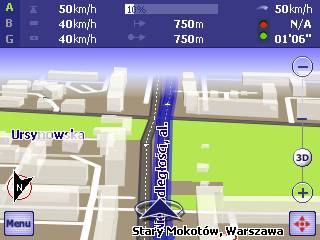
La ventana se presenta en la pantalla anterior, y que contiene la siguiente información:
|
|
El contador sección muestra la actualidad conjunto seleccionado de metros. El 3 metros comprenden independiente conjuntos de características mostradas por la computadora de bordo. Pueden ser independiente y restablecer seleccionado para mostrar. Para ello, toque en el campo con la letra de los respectivos metro o en la columna con los valores de la velocidad - el menú contextual del ordenador de bordo se mostrará. El usuario puede elegir una serie de metros en la primera pantalla de menú, y el contador puede ponerse a cero en la segunda pantalla. Meter conjuntos A y B se restablecen cada vez que se inicia AutoMapa y el GPS se activa, mientras conjunto G es un 'permanente' metro - que continúa en vigor hasta el reset manual. |
|
|
La velocidad sección muestra los siguientes datos sobre la dada metros, desde la parte superior: velocidad máxima, velocidad media, velocidad media y tiempo de parada incluida. |
|
|
La distancia sección muestra los siguientes datos, desde la parte superior: distancia de la última parada y de toda la distancia recorrida desde el sistema de activación (o metro reset). La ruta barra de progreso se muestra más arriba, mostrando el porcentaje de la ruta recorrida hasta el momento (sólo en caso de la ruta ha sido previamente asignada). |
|
|
Esta es su velocidad actual. |
|
|
El tiempo sección muestra los siguientes datos, desde la parte superior: el total de tiempo de paro total y el tiempo de conducción. |
PI Advertencias
 PI advertencias es una función que
informa al usuario acerca de acercarse a un punto de una determinada categoría.
Se puede utilizar para
advertir al usuario de puntos peligrosos o los radares de tráfico en la ruta. Esta función también notifica al usuario de los
puntos del interés en el área de visualización de la información pertinente,
por ejemplo, restaurantes o cajeros automáticos. El PDI advertencias función está activa en el
espectáculo y el modo de posición durante la navegación. Cuando la función de aviso se activa, los cambios en
el sistema de la escala que aparece el mapa para garantizar la máxima
visibilidad de los habida cuenta de PI.
PI advertencias es una función que
informa al usuario acerca de acercarse a un punto de una determinada categoría.
Se puede utilizar para
advertir al usuario de puntos peligrosos o los radares de tráfico en la ruta. Esta función también notifica al usuario de los
puntos del interés en el área de visualización de la información pertinente,
por ejemplo, restaurantes o cajeros automáticos. El PDI advertencias función está activa en el
espectáculo y el modo de posición durante la navegación. Cuando la función de aviso se activa, los cambios en
el sistema de la escala que aparece el mapa para garantizar la máxima
visibilidad de los habida cuenta de PI.
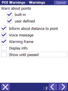
El 'PI Advertencias' ventana en el menú principal se puede utilizar para seleccionar categorías de PDI y establecer la 'advertencia' mensaje de características.
Dos advertencias categorías de PDI se activa por defecto: 'Radar' y 'lugar peligroso'.
Un punto dado categoría se selecciona tocando en las plazas que aparece a la izquierda del nombre de categoría. Al pulsar en el primero, azul oscuro cuadrados, el usuario muestra PDI de la categoría determinada, que se construyen en el mapa. El segundo, cuadrado negro aparece definido por el usuario, los puntos (la primera plaza del definidos por el usuario punto categoría, cuyo nombre difiere de la categoría estándar, está en gris).
El 'Opciones' y 'Ver' botones tienen funciones idénticas a las de la 'PI Display' pantalla.
 El número de categorías de PDI
advertencias deben ser seleccionados cuidadosamente para asegurar que las
principales funciones del sistema no se interrumpieron durante la navegación.
El número de categorías de PDI
advertencias deben ser seleccionados cuidadosamente para asegurar que las
principales funciones del sistema no se interrumpieron durante la navegación.
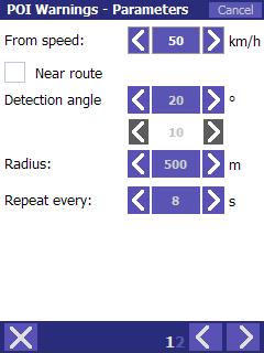
Después de seleccionar el punto categorías, alerta parámetros pueden ser modificados por separado para cada categoría. Toque en el nombre de categoría para abrir la pantalla de parámetros.
En la primera pantalla, el usuario puede establecer los parámetros para activar el mensaje de advertencia, que puede aparecer en 2 modos:
Cerca de ruta - el sistema indica: un mínimo de la velocidad del vehículo (de 5 kilometros / hora a 130 kilometros / h), la distancia entre el punto y la ruta (en el respeto de varias vías carreteras, los puntos a la izquierda de la carretera no se tienen en cuenta , En Gran Bretaña e Irlanda - los puntos a la derecha de la carretera), la distancia a la que se detectan puntos en el camino.
No en la ruta - el sistema indica: un mínimo de la velocidad del vehículo (de 5 kilometros / hora a 130 kilometros / h) y el radio interior del PDI que se detectan en el recorrido dirección (cuanto mayor sea el ángulo y el radio, cuanto mayor sea el número de puntos que se activará el mensaje de advertencia).
El 'Repetir cada' opción define el mínimo intervalo de tiempo entre mensajes de advertencia posterior en el mismo punto.
 En la segunda pantalla, el usuario
puede seleccionar los puntos en la categoría determinada, para que los mensajes
de advertencia se activa (las opciones de 'built-in' puntos y
'definido por el usuario' puntos son idénticas a las plazas para la
selección de categorías punto).
El usuario también puede definir la forma en que el mensaje de advertencia se
comunicará:
En la segunda pantalla, el usuario
puede seleccionar los puntos en la categoría determinada, para que los mensajes
de advertencia se activa (las opciones de 'built-in' puntos y
'definido por el usuario' puntos son idénticas a las plazas para la
selección de categorías punto).
El usuario también puede definir la forma en que el mensaje de advertencia se
comunicará:
Informar acerca de la distancia al punto - la distancia que se muestra en el mapa junto al icono del punto, y un mensaje de voz informando al usuario de la distancia hasta el punto se genera.
Mensaje de voz - el mensaje de advertencia será acompañado por un sonido.
Advertencia marco - un marco rojo se dibuja alrededor del icono de punto en el mapa.
Mostrar información - un 'globo' se muestra por encima del punto con la siguiente información: nombre y la descripción.
Mostrar hasta el pasado - el mensaje de advertencia para el punto dado seguirá categoría que se mostrará hasta que el usuario pasa por el punto.
Después de que el usuario modifica los parámetros de alerta y cierra la ventana respectiva, el sistema le preguntará si los parámetros utilizados deben guardar como defecto. Cuando el usuario selecciona 'Sí', todos los puntos categoría escogida en el futuro tendrán el mismo mensaje de advertencia parámetros.
La selección de la muestra del mensaje de advertencia parámetros
Advertencia contra los peligrosos puntos en el camino:
|
A partir de la velocidad |
50 km / h |
|
Cerca de ruta: |
Sí |
|
Distancia de la ruta: |
P 20 m |
|
L 50 m |
|
|
Distancia hacia el futuro: |
500 m |
|
Repetir cada: |
8 s |
|
Informar acerca de la distancia al punto: |
Sí |
|
Mensaje de voz: |
Sí |
|
Advertencia marco: |
Sí |
|
Mostrar Información: |
no |
|
Mostrar hasta el pasado: |
Sí |
Información sobre restaurantes de la zona:
|
A partir de la velocidad: |
5 km / h |
|
Cerca de ruta: |
no |
|
Ángulo de detección: | |
|
Radio: |
500 m |
|
Repetir cada: |
Una vez |
|
Informar acerca de la distancia al punto: |
no |
|
Mensaje de voz: |
no |
|
Advertencia marco: |
no |
|
Mostrar Información: |
Sí |
|
Mostrar hasta el pasado |
no |
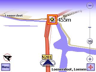 La pantalla se muestra un ejemplo de mensaje de advertencia al conductor
contra una carretera en el punto 'lugar peligroso' categoría. El sistema genera un mensaje de
sonido e indica la distancia al punto. El punto se muestra en un marco, y la escala del mapa
se ajusta para hacer el punto claramente visible.
La pantalla se muestra un ejemplo de mensaje de advertencia al conductor
contra una carretera en el punto 'lugar peligroso' categoría. El sistema genera un mensaje de
sonido e indica la distancia al punto. El punto se muestra en un marco, y la escala del mapa
se ajusta para hacer el punto claramente visible.
Usuario de sonidos de alerta
El usuario puede personalizar los sonidos de alerta para dar la categoría de PDI. Para ello, su copia. Archivo WAV (preferiblemente 22 kHz / 8 bits / mono) con un nombre idéntico al nombre de la categoría de PI para las 'voces' en la carpeta AutoMapa directorio de instalación.
Navegación
Navegación AutoMapa es un modo de funcionamiento, en que el sistema indica la posición del usuario en el mapa (si es por GPS) y los mapas de ruta. En el modo de navegación, AutoMapa guía al usuario hasta el punto de destino de mostrar los mapas de ruta y la posición del vehículo en el mapa, y muestra el panel piloto, que notifica al usuario acerca de las próximas maniobras, acompañada de mensajes de voz.
Hay dos maneras de iniciar la navegación:
seleccionando el punto de destino con el uso de la 'Ir a' opción: el sistema de mapas de la ruta, muestra toda la ruta en la pantalla, genera un mensaje de voz en la longitud de la ruta y el tiempo necesario para llegar al destino, se activa la navegación y después de unos segundos, o
la cartografía de la ruta con START y END puntos, o activar el GPS de navegación (GPS, si ya está a) en el 'GPS' menú
Cartografía de la ruta
 Para el mapa de ruta, el usuario
tiene que definir al menos dos puntos - el principio y el final de la ruta. Se pueden configurar en el mapa o con el uso de la
'Ir a la' opción de menú, seleccionando el inicio o al final la
opción en el menú contextual. El sistema le preguntará al
usuario si la ruta debe ser trazado y lo hará después
de recibir una respuesta afirmativa.
Para el mapa de ruta, el usuario
tiene que definir al menos dos puntos - el principio y el final de la ruta. Se pueden configurar en el mapa o con el uso de la
'Ir a la' opción de menú, seleccionando el inicio o al final la
opción en el menú contextual. El sistema le preguntará al
usuario si la ruta debe ser trazado y lo hará después
de recibir una respuesta afirmativa.
Si el usuario selecciona 'Ir a' opción en el menú contextual de cualquier punto en el mapa o cualquier otro objeto, la ruta es trazada entre el usuario de la posición actual y el punto seleccionado, y la navegación se activa automáticamente. El curso de los mapas de ruta se puede modificar con el uso de 'a través de' puntos (que también puede ser fijado en el menú contextual). 'A través de' puntos de fuerza de la ruta se entrecruzan a un lugar determinado. Antes de la ruta al nuevo destino se confirma, el sistema puede preguntar si para eliminar las no numeradas por los puntos de la ruta anterior.
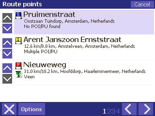
La secuencia de puntos de la ruta se puede modificar en la 'ruta' del menú, seleccionando la opción 'Información' en la opción 'puntos de ruta' ventana. La opción contiene valiosa información sobre los mapas de ruta: una lista de maniobras, una comparación de viajar la distancia y el tiempo a lo largo de diversas categorías de carreteras, etc Otra forma de reordenar los puntos de ruta es utilizar el 'Cortar y Pegar' comandos en el menú emergente .
La ruta de retorno puede ser trazado con el uso de la 'reversa' en la opción 'Ruta' del menú.
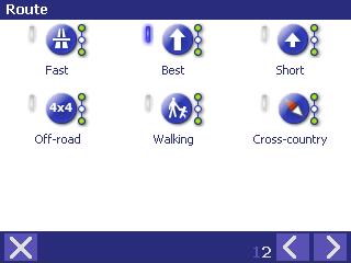 El tipo de
ruta se pueden cambiar con el uso de opciones en la
segunda ventana de la 'ruta' del menú. El sistema
es compatible con los siguientes tipos de ruta:
El tipo de
ruta se pueden cambiar con el uso de opciones en la
segunda ventana de la 'ruta' del menú. El sistema
es compatible con los siguientes tipos de ruta:
Rápido
La ruta será asignada a lo largo de carreteras con el más alto rendimiento. Debería ser más rápido que otras rutas, pero ten en cuenta que el rendimiento valores no tienen en cuenta los atascos de tráfico o de otro tipo no estándar situaciones.
Corto
El sistema de ruta la ruta más corta posible, evitando las carreteras de la categoría más baja (por ejemplo, caminos de tierra).
Mejor
La ruta se cuenta para los parámetros de la rápida y corta la ruta, es decir, tanto el rendimiento de las carreteras y viajó total recorrido de la línea. La 'Configuración / Ruta' opción en el menú principal se puede utilizar para definir la ruta que el parámetro (a distancia / velocidad) tiene prioridad.
Off-road
El sistema de ruta la ruta más corta posible sin tener en cuenta la categoría de carretera. La ruta lo más pronto posible, podría dar lugar a través de secciones de menor categoría carreteras, incluyendo caminos de tierra.
Paseos
La ruta no cuenta para la dirección del tráfico, no entran en los signos o carretera categorías. Esta es una opción útil para los usuarios que viajan a pie o en bicicleta. La ruta es no figura en el mapa internacional a lo largo de las carreteras o autopistas.
 Si su receptor GPS se ha conectado
y configurado correctamente, y la ruta ha sido mapeado, AutoMapa cambia
automáticamente al modo de navegación.
En este modo, el mapa operación es idéntico al que en la Mostrar el modo de
posición GPS. El recorrido (la distancia
recorrida se muestra en un color diferente) y las flechas de las próximas
maniobras se muestran en el mapa.
Si su receptor GPS se ha conectado
y configurado correctamente, y la ruta ha sido mapeado, AutoMapa cambia
automáticamente al modo de navegación.
En este modo, el mapa operación es idéntico al que en la Mostrar el modo de
posición GPS. El recorrido (la distancia
recorrida se muestra en un color diferente) y las flechas de las próximas
maniobras se muestran en el mapa.
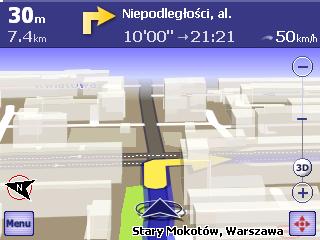
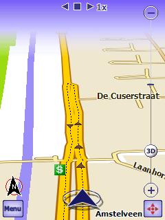
El grupo piloto, notificando al usuario acerca de la próxima maniobra y el nombre de la calle donde la maniobra se llevará a cabo, se muestra en la pantalla. El piloto del panel de información que aparece en la parte derecha de la pantalla debe leerse como sigue: después de 30 metros el usuario deberá girar a la derecha en Aleje Niepodleglosci la calle, hay 7,4 km hasta el destino, que tendrá 10 minutos. El destino debe ser alcanzado a 9:21 pm velocidad actual es de 50 km / h.
Aprovechar las secciones individuales del panel permite la visualización de información adicional: Cuando escuchas en el grupo piloto en ETA (hora estimada de llegada), en primer lugar la ruta se muestra fragmento de una distancia y, a continuación, toda la ruta. El tercer toque vuelve a la posición de visualización.
La próxima maniobra es anunciada por mensajes de voz, que indican tanto el tipo de maniobra y la distancia a la maniobra - en este caso: 'después de 160 m, gire a la derecha'.
La navegación en AutoMapa es cómodo y práctico gracias a la ruta función de corrección automática.
 Esta
función apoya navegación automática cuando el receptor GPS señales de que el
usuario está fuera de la ruta. No puede haber muchas razones para ir fuera de la
ruta: atascos, obras en la carretera, accidente, error del conductor, mapa de
error, GPS inexactos lectura, etc En la práctica, esto sucede muy a menudo. Gracias a la corrección automática, el conductor no
tiene que hacer independiente de los intentos de volver a la ruta asignada o
establecer manualmente una nueva ruta desde la posición actual - esto se hará
por AutoMapa.
Cuando el conductor se apaga la ruta asignada, se AutoMapa esperar unos
segundos (para asegurarse de que no se trata de una maniobra planificada, por
ejemplo, un intento de pasar por alto una hoja de obstrucción), y automáticamente
el mapa una nueva ruta en línea con la anteriormente puntos de ajuste, a partir
de la del propio usuario.
Esta
función apoya navegación automática cuando el receptor GPS señales de que el
usuario está fuera de la ruta. No puede haber muchas razones para ir fuera de la
ruta: atascos, obras en la carretera, accidente, error del conductor, mapa de
error, GPS inexactos lectura, etc En la práctica, esto sucede muy a menudo. Gracias a la corrección automática, el conductor no
tiene que hacer independiente de los intentos de volver a la ruta asignada o
establecer manualmente una nueva ruta desde la posición actual - esto se hará
por AutoMapa.
Cuando el conductor se apaga la ruta asignada, se AutoMapa esperar unos
segundos (para asegurarse de que no se trata de una maniobra planificada, por
ejemplo, un intento de pasar por alto una hoja de obstrucción), y automáticamente
el mapa una nueva ruta en línea con la anteriormente puntos de ajuste, a partir
de la del propio usuario.
Al pulsar en el icono de la barra de maniobra (en el ejemplo anterior - el derecho a su vez la flecha), el usuario puede reproducir el mensaje de maniobra o modificar el mensaje de nivel de sonido.
 Al igual
que el modo de mostrar la posición, al tocar la pantalla durante la navegación,
el usuario abra el menú emergente. Se diferencia del
menú principal en los siguientes aspectos:
Al igual
que el modo de mostrar la posición, al tocar la pantalla durante la navegación,
el usuario abra el menú emergente. Se diferencia del
menú principal en los siguientes aspectos:
'Bloquear después de la próxima maniobra' y 'desvío' - una nueva ruta puede ser trazado para evitar obstrucciones de tráfico (para obtener más información, consulte el 'Bloque de carreteras' capítulo).
'Conjunto de escala para la conducción' - por defecto restaura escala del mapa, lo cual es óptimo para la navegación por carretera.
 Tramos de carretera en el mapa
puede ser libremente bloqueado y que se omitió en el algoritmo de mapeo de
ruta. Las secciones seleccionadas
se considerará como intransitable y se evitarán. Tramos de
carretera pueden ser bloqueados durante un período específico de tiempo,
indicando el comienzo y las fechas de finalización.
Tramos de carretera en el mapa
puede ser libremente bloqueado y que se omitió en el algoritmo de mapeo de
ruta. Las secciones seleccionadas
se considerará como intransitable y se evitarán. Tramos de
carretera pueden ser bloqueados durante un período específico de tiempo,
indicando el comienzo y las fechas de finalización.
Tramos de carretera con un tráfico de prohibición también se puede desbloquear para la ruta: desbloqueado el tramo de carretera serán utilizados en la navegación. Las secciones que el usuario desbloqueados se muestran en el mapa en un color diferente.
Para bloquear un segmento, abra el menú contextual en el segmento dado por carretera (se refieren al 'Menú contextual' capítulo) y seleccione la opción 'Bloquear la sección'. El sistema le preguntará si una fecha de vencimiento debe ser asignado a la sección bloqueada. Si la respuesta es 'sí', se debe indicar la fecha. Siga los mismos pasos para desbloquear un tramo de carretera que está marcado como intransitable en el mapa utilizando el 'Desbloquear la sección'. A continuación, el usuario puede entrar en el comienzo y / o fecha de finalización de los bloques.
La sección suele ser bloqueado entre los dos más cercanos encrucijada. Por supuesto, existe la posibilidad de bloquear el tráfico sólo una dirección en caso de una multilane carretera.
Una sección está bloqueada por lo general entre dos cruces más cercano. El usuario puede, evidentemente, un bloque en un solo sentido de tráfico en un carril de multi-carril de carreteras.
Siga los mismos pasos (sin que se preguntó acerca de la fecha de caducidad) para desbloquear un bloqueado previamente la sección Desbloquear la sección'). La fecha de caducidad también puede ser modificado Sección bloque parámetros').
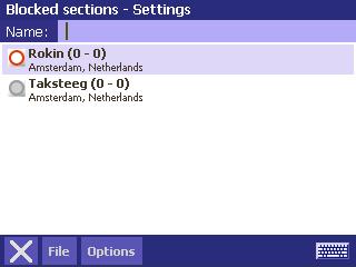 Bloque de parámetros también puede ser modificado con
el uso de las 'secciones bloqueados' opción en el menú principal y el
menú de configuración. La lista de todas las secciones bloqueadas se
muestra: bloqueado las secciones están marcados con un círculo rojo
(prohibición del tráfico), y desbloquear los artículos - con un círculo gris.
Esta opción permite al
usuario: ver la sección bloqueada en el mapa, desbloquear la sección o
modificar su comienzo y / o fecha de caducidad, eliminar todas las secciones
bloqueadas. Bloqueado secciones pueden ser guardados en el archivo, leer,
añaden, a partir de un archivo o importados de versiones anteriores del
sistema.
Bloque de parámetros también puede ser modificado con
el uso de las 'secciones bloqueados' opción en el menú principal y el
menú de configuración. La lista de todas las secciones bloqueadas se
muestra: bloqueado las secciones están marcados con un círculo rojo
(prohibición del tráfico), y desbloquear los artículos - con un círculo gris.
Esta opción permite al
usuario: ver la sección bloqueada en el mapa, desbloquear la sección o
modificar su comienzo y / o fecha de caducidad, eliminar todas las secciones
bloqueadas. Bloqueado secciones pueden ser guardados en el archivo, leer,
añaden, a partir de un archivo o importados de versiones anteriores del
sistema.
Lo anterior pantallas muestran un bloqueada la sección de la calle Rokin y Taksteeg desbloqueado la calle.
Si el 'Bloque de la sección después de maniobra' opción se utiliza, el sistema bloqueará la sección de la ruta directamente después de la próxima maniobra. Esta es una opción útil cuando el usuario tiene intención de, por ejemplo, gire a la derecha y los avisos de que el camino está bloqueado detrás de la curva. Cuando el usuario toques de 'Bloquear la sección después de maniobra', AutoMapa mapa automáticamente una ruta alternativa al omitir la sección bloqueada.
El 'desvío' opción tiene una función similar, pero se aplica a un tramo de la ruta con una duración preestablecido. Esta es una función útil cuando, por ejemplo, el conductor ve un atasco por delante con la duración estimada de 500 m. Cuando el usuario toques de 'desvío' y luego 'Siguiente 500 m', el sistema bloqueará todas las secciones de cruce más cercano a lo largo de la distancia de 500 m en la ruta preestablecido. Desvío bloques pueden ser eliminados con el uso del 'Desvío | Eliminar desvíos'.
Desvío bloques se eliminan automáticamente cuando el usuario sale del programa.
Bloqueado las carreteras y la vía de cartografía
El sistema puede utilizar una sección para bloquear la ruta de ruta en las siguientes situaciones:
cuando un punto de ruta se encuentra bloqueada en un tramo de carretera,
si la desviación forzada de la hoja bloque es demasiado largo en comparación con la ruta principal a través de la sección bloqueada.
Esta sección describe características avanzadas del sistema omitido anteriormente, así como todos los ajustes disponibles en diferentes seleccionables por las pantallas de las aplicaciones.
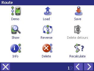 Menú de ruta incluye muchas
opciones útiles para el cálculo y la manipulación AutoMapa rutas. El menú se divide en dos
pantallas, seleccionar pulsando <y> botones. Para salir a la ventana principal,
toque X. La mayoría de las opciones de menú sólo están disponibles para el
cálculo de ruta.
Menú de ruta incluye muchas
opciones útiles para el cálculo y la manipulación AutoMapa rutas. El menú se divide en dos
pantallas, seleccionar pulsando <y> botones. Para salir a la ventana principal,
toque X. La mayoría de las opciones de menú sólo están disponibles para el
cálculo de ruta.
En modo simplificado, las 'carreteras' del menú se compone sólo de ruta clave relacionadas con opciones. La sección a continuación se describe la versión completa de la pantalla de menú.
Demo
Seleccione Demo para mostrar una demostración de la ruta calculada. La operación es idéntica a la reproducción de la pista GPS almacenados. Después de alcanzar el destino, la manifestación se inicia una vez más.
Cargar
Cargas puntos de ruta previamente guardado en el archivo atm (seleccionados de entre los árboles archivo en la memoria del dispositivo).
Salvar
Paradas puntos de ruta a atm archivo, que puede ser guardado en cualquier ubicación en la memoria del dispositivo.
Mostrar todos
La aplicación escalas en el mapa para ajustar la ruta completa en la pantalla.
Reverse
Invierte el orden de puntos de ruta para crear una ruta de retorno que conecta los mismos puntos, pero en el orden inverso al anteriormente calculado.
Eliminar desvíos
Elimina temporales desvíos de las secciones bloqueadas, creado por el 'desvío' en la función 'Mostrar posición' menú emergente.
Info
 Multi-pantalla el cuadro de diálogo
que ofrece información relacionada con la ruta calculada, como una lista de
maniobras, duración, ETA (separados por carretera en los grados).
Multi-pantalla el cuadro de diálogo
que ofrece información relacionada con la ruta calculada, como una lista de
maniobras, duración, ETA (separados por carretera en los grados).
Información también incluye una opción de reordenamiento PDI (usando botones de flecha a la izquierda del PI) y una simple optimización de por los puntos que consiste en encontrar el punto A TRAVÉS más cercano (en línea recta) para el punto de inicio. A continuación, el segundo punto más cercano se encuentra, etc, hasta que todos los puntos A TRAVÉS han sido reordenados.
Borrar
Elimina los puntos de ruta establecido en el mapa.
Recalcular
Recalcula la ruta predefinida. La opción estará disponible en caso de puntos de ruta se han establecido y su cálculo se le negó. En el modo de navegación, es sustituido con la opción llamada 'Calcular de la posición actual'.
Rápido
Calcula una vía rápida.
En caso de puntos de ruta se han establecido, se recalcula la ruta actual de
conformidad con la vía rápida algoritmo, y si no los puntos se han establecido,
cambia el tipo de ruta que se calcula.
Para obtener más información sobre las rutas, consulte la sección 'Ruta de
cálculo'.
Mejor
Calcula el mejor camino, es decir, la media entre la vía rápida (donde el rendimiento es la prioridad) y el corto. Puede cambiar la relación entre los dos tipos en la configuración.
Corto
Calcula un corto recorrido.
Off-road
Calcula una carretera fuera de ruta.
Paseos
Calcula una ruta a pie.
GPS menú
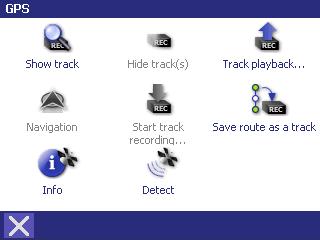 GPS menú grupos de funciones
necesarias para la operación de dispositivos GPS en los AutoMapa sistema de
navegación.
GPS menú grupos de funciones
necesarias para la operación de dispositivos GPS en los AutoMapa sistema de
navegación.
GPS pistas
Un GPS es vía la información almacenada en el PC, obtenidos a partir de la antena GPS, que puede ser guardado en AutoMapa cuando el receptor GPS está activado. La pista se guarda en dos archivos con el definido por el usuario y los nombres de las siguientes extensiones Gps y gps.bin.
Mostrar pista
Muestra el trazado guardado como una línea verde en el mapa. El mapa está a escala para adaptarse a la pista completa en la pantalla. La pantalla también puede mostrar varias pistas simultáneamente.
Ocultar pista (s)
Ocultar pista (s) está representada en el mapa.
Pista de reproducción
 Muestra la posición GPS basada en pista guardado
previamente. La operación es similar a la conducción con el receptor de
GPS activado, también la característica de navegación está disponible.
Muestra la posición GPS basada en pista guardado
previamente. La operación es similar a la conducción con el receptor de
GPS activado, también la característica de navegación está disponible.
Durante un seguimiento de reproducción, la parte superior de la pantalla muestra las teclas que la velocidad, detenerse o acelerar la reproducción de pista. El número a la derecha de las teclas se muestra la velocidad de reproducción como un múltiplo de la velocidad de conducción.
Habilitar el seguimiento de almacenamiento
Después de proporcionar el nombre del archivo y la ubicación, la información del receptor GPS se guardarán. Esto es simbolizado por un cuadrado rojo en la esquina superior izquierda de la pantalla.
Guardar ruta como una pista
Convierte la ruta calculada en el mapa y lo guarda como un GPS vía. El archivo resultante puede utilizarse como un modelo de seguimiento GPS de grabación en directo.
Otras funciones de GPS
Navegar / Mostrar posición
Dependiendo de si la ruta se ha establecido o no, esta opción puede ser llamado 'Navegar' o 'Mostrar posición', respectivamente. Enabled GPS le permite a su vez en la barra de navegación o posición que muestra el modo.
Info
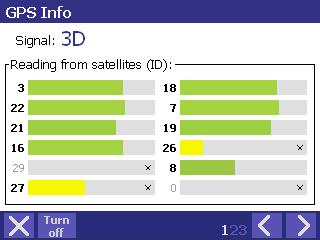 Este cuadro de diálogo muestra 3 pantallas
de información sobre la actual señal GPS:
Este cuadro de diálogo muestra 3 pantallas
de información sobre la actual señal GPS:
nivel de la señal de satélite - barras verdes mostrar la fuerza relativa de la señal GPS de los satélites utilizados por la antena, las barras de color amarillo - de otros satélites detectados,
su posición actual, velocidad y altura, y la dirección,
actual de crudo de volcado de datos GPS en forma de texto.
Activar / Desactivar / Detectar
Dependiendo de la operación actual, esta opción activar o desactivar el GPS. Si el puerto del GPS no se ha detectado automáticamente, la operación se puede repetir cuando esta opción se llama 'Detectar'.
Menú de ajustes
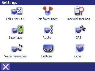 En el menú de configuración
(seleccione 'Configuración' desde el menú principal) puede cambiar
muchos parámetros útiles de AutoMapa que se ajuste a sus preferencias y
necesidades de su dispositivo.
En el menú de configuración
(seleccione 'Configuración' desde el menú principal) puede cambiar
muchos parámetros útiles de AutoMapa que se ajuste a sus preferencias y
necesidades de su dispositivo.
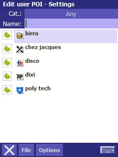
Editar usuario PDI - Configuración
El acceso a los Puntos de usuario definidos o añadido por el usuario.
La pantalla muestra una lista de PDI, con categoría de icono, PDI nombre y la descripción. Un mapa cuadrado de la izquierda muestra que la PI se mostrará en el mapa. Puede filtrar por el nombre PDI (entrando en una parte del PI nombre o la descripción en el 'Nombre') o por categorías (se selecciona una categoría de aprovechar el 'Todo' etiqueta).
 Después de seleccionar una categoría puede eliminar
fácilmente los seleccionados PDI: la categoría de icono desaparecerá, para ser
sustituido por un icono de papelera de reciclaje.
Después de tocar la imagen se puede seleccionar un PDI que se suprima.
Para eliminar tales PDI, toque el botón 'Eliminar' y elija la opción
'Eliminar seleccionados'.
(También puede seleccionar todos los PDI en una determinada categoría tocando
el botón 'Eliminar' y seleccionando la opción 'Seleccionar
todo').
Después de seleccionar una categoría puede eliminar
fácilmente los seleccionados PDI: la categoría de icono desaparecerá, para ser
sustituido por un icono de papelera de reciclaje.
Después de tocar la imagen se puede seleccionar un PDI que se suprima.
Para eliminar tales PDI, toque el botón 'Eliminar' y elija la opción
'Eliminar seleccionados'.
(También puede seleccionar todos los PDI en una determinada categoría tocando
el botón 'Eliminar' y seleccionando la opción 'Seleccionar
todo').
El botón 'Archivo' permite operaciones básicas en los archivos de PDI (o en realidad un par de archivos con extensiones. PDI y. Poipts).
El menú muestra la cabecera de información sobre el archivo cargado actualmente.
En caso de 'Carga de archivo estándar' está seleccionado, el archivo por defecto será cargada (es decir, archivos default.poi y default.poipts de los 'archivos de datos' carpeta).
'Crear un nuevo archivo' - crea nueva, vacía archivo de PI.
'Cargar archivo' - Carga un archivo de PI existentes.
'Guardar archivo' - guarda una copia del archivo cargado actualmente con un nombre diferente y / o en una carpeta distinta.
'Añadir a archivo' - Puntos de carga de un archivo seleccionado a la actual.
'Importar' - las importaciones de un PDI AutoMapa 3 archivo (. UAM) o un archivo de texto (. CSV). Esta opción permite la carga de PDI poi.mobilne.net en el sitio web. UAM formato. El sistema le preguntará si desea crear un nuevo archivo para la importación de PDI. Al seleccionar 'No', le añadiremos la PI para el actual archivo de PI; seleccionando 'Sí', usted va a crear un nuevo archivo de PI en la misma carpeta que el archivo importado.
Al pulsar en uno de los PDI, que se abrirá un menú emergente que, además de las opciones descritas anteriormente, se incluirá la 'Editar ' función, lo que le permite cambiar la categoría, el nombre y la descripción de cualquier punto de interés.
Bloqueado secciones - Configuración
Para obtener más información, consulte la sección 'Bloquear carreteras'.
Interface - Configuración
Con interfaz de configuración se puede cambiar la apariencia de la pantalla de acuerdo con sus preferencias.
Preferencias
 En este menú puede activar o
desactivar las siguientes funciones utilizadas durante la navegación:
En este menú puede activar o
desactivar las siguientes funciones utilizadas durante la navegación:
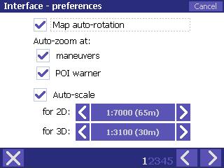
'Mapa de auto-rotación' - para mostrar la posición y el modo de navegación, el mapa se rueda en la dirección de rotación de usuarios. En caso de los discapacitados, el mapa será siempre orientadas al norte, y el cursor de posición GPS se encuentra en el centro de la pantalla. Nota: esta opción no se aplica a la rotación de mapa en modo 3D, es decir, el mapa auto-rotación puede desactivarse sólo en modo de visualización 2D.
'Auto zoom' a 'maniobras / POI Warner' - escala del mapa será cambiado a maniobras o POI Warner, para garantizar una mejor visibilidad.
'Auto-escala' del mapa al mostrar la posición y el modo de navegación en 2D y 3D se especifica el modo de visualización de la escala por defecto para los dos modos de pantalla.
Mapa
 En este cuadro puede cambiar la
forma en que el mapa se mostrará en la pantalla del dispositivo.
En este cuadro puede cambiar la
forma en que el mapa se mostrará en la pantalla del dispositivo.
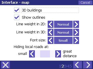
'Edificios en 3D' - se convierte en la muestra de bloques de construcción.
'Mostrar esboza' - desactiva líneas generales de tramos de carretera en la ruta, la aceleración de AutoMapa operación.
'Línea de peso' - divide en 2D y 3D modo, y especificando la línea de peso relativo de las secciones de carretera en el mapa.
'Tamaño', se especifica el tamaño de las fuentes que aparecen en el mapa.
'Ocultar las carreteras locales en: pequeño / gran distancia', se especifica la escala para ocultar grado inferior carreteras.
Colores y ver
 Con estas opciones puede ajustar los colores del mapa
para reflejar sus preferencias, y cambiar la forma de su pantalla en modo 3D.
Con estas opciones puede ajustar los colores del mapa
para reflejar sus preferencias, y cambiar la forma de su pantalla en modo 3D.
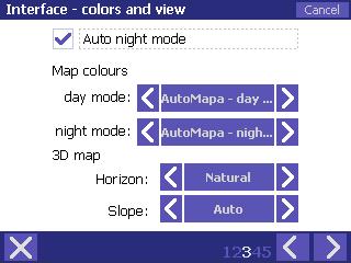
'Auto modo nocturno' -, si está activada, AutoMapa automáticamente (basado en GPS indicaciones de la posición actual, la hora del día y temporada) cambiar a modo nocturno y cambiar los colores del mapa y otros componentes para la pantalla de opciones adecuadas para la navegación nocturna, que no se cansa de sus ojos o persianas cuando el coche interior es oscuro.
'Mapa de colores' - especifica el mapa de color, seleccionados por separado para el día y modo nocturno.
'Mapa 3D' - especifica el método para visualizar el horizonte en '3D', y el mapa de pendiente, en función de la escala Auto') o en un conjunto de valor.
Elementos y extras
 En estas cajas se puede seleccionar
los paneles de información y extras que se visualiza en la pantalla de mapa,
así como el funcionamiento del sistema que muestra en posición de navegación y
los modos de transporte.
En estas cajas se puede seleccionar
los paneles de información y extras que se visualiza en la pantalla de mapa,
así como el funcionamiento del sistema que muestra en posición de navegación y
los modos de transporte.
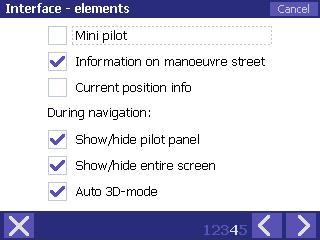
'Mini piloto' - el piloto que aparece en el modo de navegación en la pantalla se ocupan menos espacio.
'Información sobre la maniobra de la calle' - piloto panel que muestra el nombre de la próxima maniobra de la calle.
'La posición actual en' - información adicional panel que muestra una descripción de la situación actual en el mapa, compuesto por el nombre de la calle, ciudad / nombre de la ciudad y el código del país.
'Durante la navegación' - las opciones de especificar si el grupo experimental se muestra automáticamente en modo de navegación (si no, puede abrirlo desde el menú principal), y si la 'Mostrar posición' opción permite automáticamente a pantalla completa y el modo de visualización 3D.
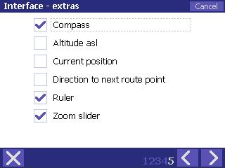 'Compass' - muestra una
flecha apuntando hacia el norte en la pantalla de mapa.
'Compass' - muestra una
flecha apuntando hacia el norte en la pantalla de mapa.
'La altitud snm' - añade la información de altitud al panel que muestra las coordenadas GPS.
'Posición actual' - información adicional panel que muestra las coordenadas de la posición GPS actual.
'Dirección a la siguiente punto de ruta' - muestra una flecha adicional en la pantalla del mapa, mostrando la dirección a la ruta siguiente punto (ya sea a través de un punto o punto de destino).
'Gobernante' - la presentación de un gobernante la escala del mapa (sólo en modo 2D).
'Zoom deslizador' - se puede utilizar el control deslizante para cambiar fácilmente la escala del mapa visualizado. En el modo 3D, la perspectiva de la pantalla es de sólo el apoyo en la parte baja del mapa escalas, y el botón deslizante muestra '3D', y el límite para mostrar la perspectiva está representada por una línea transversal en todo el centro de la barra deslizante.
Ruta - Configuración
En este cuadro de diálogo se puede especificar parámetros adicionales para el cálculo de ruta AutoMapa función.
Cálculo
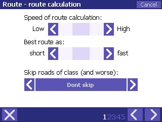 'La velocidad de cálculo de ruta' -, regula
los parámetros de la heurística de determinar el algoritmo de cálculo de ruta,
la relación es la siguiente: parte inferior de velocidad = mejor algoritmo de
precisión.
'La velocidad de cálculo de ruta' -, regula
los parámetros de la heurística de determinar el algoritmo de cálculo de ruta,
la relación es la siguiente: parte inferior de velocidad = mejor algoritmo de
precisión.
'Mejor ruta' - introduce parámetros para el algoritmo de cálculo de la mejor ruta como la ruta más decidida sobre la base de hoja de rendimiento (vía rápida) o su duración (corto recorrido).
'Pasar las carreteras de la clase (y peor)' - salta tramos de carretera de la clase igual o peor que se especifique lo contrario. La opción no se aplica a las off-road o rutas a pie.
Preferencias
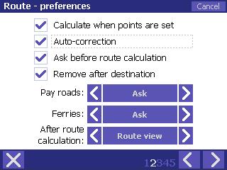 'Calcular cuando se establecen puntos' -,
si está activada, AutoMapa calculará la ruta después de START y END puntos; si
discapacitados, el sistema le recuerde la ruta puntos, pero no calcular la
ruta.
Para calcular una ruta sobre la base de esos puntos, utilizar el 'Volver a
calcular la ruta' en la ruta menú.
'Calcular cuando se establecen puntos' -,
si está activada, AutoMapa calculará la ruta después de START y END puntos; si
discapacitados, el sistema le recuerde la ruta puntos, pero no calcular la
ruta.
Para calcular una ruta sobre la base de esos puntos, utilizar el 'Volver a
calcular la ruta' en la ruta menú.
'Auto-corrección' - desactiva ruta auto-corrección. AutoMapa no recalcular una ruta abandonada por el usuario.
'Preguntar antes de cálculo de ruta' - por defecto, la aplicación solicita antes de calcular una ruta después de establecer el principio y el final de puntos. En caso de los discapacitados, la ruta se calculará inmediatamente después de los puntos que se establecen (siempre que la opción 'Calcular cuando se establecen puntos' ha sido comprobado).
'Eliminar después de destino' - borra la ruta después de llegar al punto final. También puede especificar la forma en que la aplicación utiliza pagar las carreteras y transbordadores, la elección de una de las siguientes opciones: 'Pregúntele a', 'OK' (aceptar incondicionalmente) o 'Ignorar'.
La última opción especifica AutoMapa operación después de ruta cálculo; puede optar por ver la ruta completa en el mapa, visualizar la información de ruta o mostrar la primera maniobra de la ruta (junto con el grupo experimental) o no cambiar la vista de mapa a todos.
Detalles de coches
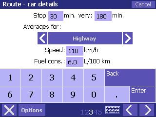 En este cuadro puede configurar la
duración y la frecuencia de las paradas programadas en la ruta, la velocidad
media de camino particular para los grados, y los relacionados con la
estimación del consumo de combustible.
En este cuadro puede configurar la
duración y la frecuencia de las paradas programadas en la ruta, la velocidad
media de camino particular para los grados, y los relacionados con la
estimación del consumo de combustible.
Los datos anteriormente mencionados influyen en el tiempo estimado de llegada (ETA), incluidos los valores presentados en la ruta info Ruta | Info' del menú), y la velocidad del tráfico en la ruta de demostración ( 'Ruta | Demo' del menú).
ETA
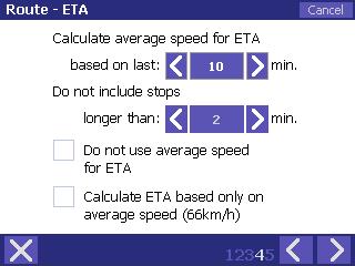 ETA es el
tiempo estimado de llegada.
ETA es el
tiempo estimado de llegada.
En esta ventana se puede especificar el método de estimar el tiempo necesario para llegar al destino. Con este fin puede utilizar velocidad media (ruta anterior configuración de pantalla) y / o la velocidad actual. Por defecto, la estimación se basa en dos parámetros. El valor en km / h, aparece en la parte inferior de la pantalla, es la actual velocidad media calculada por AutoMapa.
Otro
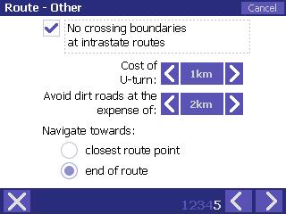 'No cruce las fronteras en las
rutas intraestatales' desactiva el cruce de fronteras cuando todos los
puntos de ruta situados en el territorio de un país.
'No cruce las fronteras en las
rutas intraestatales' desactiva el cruce de fronteras cuando todos los
puntos de ruta situados en el territorio de un país.
'El costo de U-turn', se especifica la pena para U-turnos. El número de kilómetros, se añade a la ruta longitud; cuanto mayor sea la pena, menos U-gira serán propuestos por el sistema.
'Evite caminos de tierra a costa de' - como se indica más arriba, regula la prevención de caminos de tierra durante la ruta cálculo.
'Navegar hacia' determina si la navegación es a ser relativa a la ruta más cercana a punto o el punto final.
GPS - Configuración
General
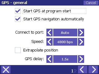 En esta ventana usted puede
seleccionar la configuración general de funcionamiento del GPS.
En esta ventana usted puede
seleccionar la configuración general de funcionamiento del GPS.
Opciones 'Inicio GPS al empezar el programa' y 'Inicio de navegación GPS automáticamente' están habilitadas por defecto.
'Conectar a puerto' y 'Velocidad' - selección de GPS puerto y su velocidad se realiza automáticamente en el COM1-9 gama de velocidades 4800 y 9600 bps. Si el dispositivo GPS utiliza un puerto COM o puerto diferente velocidad, seleccionar manualmente los parámetros correctos de acuerdo con los datos proporcionados por el fabricante.
'Extrapolar posición' - esta solución mejora la lectura del GPS basado en el análisis de la dirección y la velocidad. If enabled, the map can show a position outside the route, eg when taking a fast turn. Si está activado, el mapa puede mostrar una posición fuera de la ruta, por ejemplo, al tomar una rápida vuelta.
'GPS demora' - especifica la corrección de 'extrapolar posición'.
Avanzada
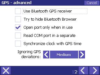 'Usar receptor GPS
Bluetooth' - se convierte en el dispositivo del módulo BT para
minusválidos. Esta opción es útil en caso de cualquier
problema con la reanudación de la conexión BT con un dispositivo de GPS tras
salir del modo de espera.
'Usar receptor GPS
Bluetooth' - se convierte en el dispositivo del módulo BT para
minusválidos. Esta opción es útil en caso de cualquier
problema con la reanudación de la conexión BT con un dispositivo de GPS tras
salir del modo de espera.
'Trate de ocultar Bluetooth Browser' - se esconde el dispositivo BT ventana de selección en los más antiguos dispositivos Windows Mobile.
Para información sobre las opciones 'Abrir puerto sólo cuando estén en uso' y 'Leer puerto COM en una hoja separada ,' no se recomienda para cambiar la configuración por defecto, a menos que usted está experimentando problemas con la conexión con el dispositivo GPS. La configuración por defecto especificado por AutoMapa.
'Sincronizar reloj con GPS tiempo' - ajusta el ordenador del sistema de reloj, sobre la base de la información incluida en la señal GPS.
'Haciendo caso omiso de GPS desviaciones', se especifica el valor de la desviación de su posición GPS de la red de carreteras en el mapa para ser ignorada, con la posición todavía preparado en un tramo de la carretera más cercana.
Mensajes de voz - Configuración
Tomo
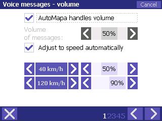 'AutoMapa maneja volumen'
- dispositivo se especifica el volumen de la solicitud.
'AutoMapa maneja volumen'
- dispositivo se especifica el volumen de la solicitud.
Nota: ajuste de volumen se hace sólo por el tiempo de jugar el sistema de mensajes de voz. El 'volumen de mensajes' slider le permite aumentar o disminuir el volumen de mensajes.
Ajuste de volumen también puede ser ejecutado automáticamente, basado en la velocidad del vehículo. Durante rápido en coche, el interior del coche es más ruidosos que durante lento unidad. Los ajustes se muestra a la derecha de la pantalla debe ser interpretada como sigue: con la velocidad por debajo de 40 km / h, el volumen se mantiene en el nivel de 50% y aumenta de forma lineal base una vez que la velocidad sea superior a 40 km / h h, sólo para lograr el máximo ajuste de 90% si la velocidad alcanza 120 km / h. A velocidades superiores a 120 km / h, el volumen se mantiene en el nivel de 90%.
Preferencias
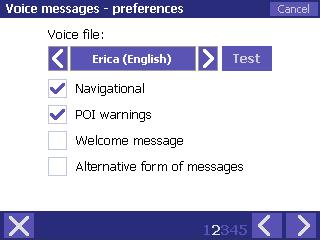 En esta ventana usted puede
seleccionar el idioma de instrucciones de voz y mensajes de voz. El 'Test'
puede utilizarse para comprobar el lenguaje y la voz de selección.
En esta ventana usted puede
seleccionar el idioma de instrucciones de voz y mensajes de voz. El 'Test'
puede utilizarse para comprobar el lenguaje y la voz de selección.
Por otra parte, se puede especificar el mensaje para permitir a los grupos, y que para desactivar (navegación, PDI advertencias, mensaje de bienvenida).
Al seleccionar 'forma alternativa de mensajes' que cambie la sintaxis de mensajes de voz de 'En 600 metros, a la derecha' a 'Derecho, a 600 metros'.
GPS
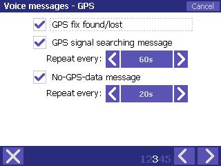 En esta ventana usted puede
seleccionar qué información sobre el estado del GPS para signalize con un
mensaje de voz.
Cuando el receptor GPS se encuentra y pierde la posición, la aplicación
desempeñará un jingle característico de la señal GPS que fijar (es decir, la
posición correcta) se ha encontrado o se pierde.
En esta ventana usted puede
seleccionar qué información sobre el estado del GPS para signalize con un
mensaje de voz.
Cuando el receptor GPS se encuentra y pierde la posición, la aplicación
desempeñará un jingle característico de la señal GPS que fijar (es decir, la
posición correcta) se ha encontrado o se pierde.
'La búsqueda de señales GPS mensaje' - el mensaje de voz es 'la búsqueda de señal GPS.' Puede cambiar la frecuencia de repetir el mensaje, o desactivar por completo.
'No-GPS-mensaje de datos' - la voz mensaje es 'No hay señal GPS.' Puede cambiar la frecuencia de repetir el mensaje, o desactivar por completo.
Frecuencia
 Esta
ventana de navegación grupos de modos de configuración (de conducción a lo
largo de la ruta establecidos, con un receptor GPS
activado). Puede
especificar si el próximo mensaje de voz para la posterior maniobra a sonar,
cuando la distancia a la maniobra no depende de la distancia física el coche
tiene que viajar pero a la hora estimada de cubrir la distancia.
Esta
ventana de navegación grupos de modos de configuración (de conducción a lo
largo de la ruta establecidos, con un receptor GPS
activado). Puede
especificar si el próximo mensaje de voz para la posterior maniobra a sonar,
cuando la distancia a la maniobra no depende de la distancia física el coche
tiene que viajar pero a la hora estimada de cubrir la distancia.
La 'Primera' mensaje de voz se reproducirá mucho antes de la maniobra para darle tiempo a prepararse (por ejemplo, cambiar el carril antes de una vuelta). The manoeuvre warning will be played at the set number of seconds before the manoeuvre, provided that the vehicle's speed exceeds the amount specified in option 'Above'. La maniobra de alerta se jugará en el número de segundos antes de la maniobra, siempre que la velocidad del vehículo es superior a la suma indicada en la opción 'Por encima'.
La posterior mensajes de voz, es decir, 'Segundo' y 'Terceros' se jugará en el número de segundos antes de la maniobra.
'Show' recto 'cuando' - define la distancia antes de la maniobra que, una vez superado, se muestra como 'recto'.
Otro
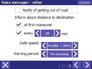 'Notifiqueme de salir de la
carretera' se refiere a un mensaje de voz después de jugado saliendo de la
carretera, informando de la necesidad de recalcular la ruta.
'Notifiqueme de salir de la
carretera' se refiere a un mensaje de voz después de jugado saliendo de la
carretera, informando de la necesidad de recalcular la ruta.
'Informar acerca de la distancia al destino' se refiere a un mensaje de voz que contiene la distancia al destino y la hora estimada de llegada; este mensaje de voz puede ser jugado en la primera maniobra y cada cantidad fija de minutos.
Si desea recibir advertencias sobre el seguro superior al límite de velocidad, puede especificar su valor y permitir una advertencia pertinentes. El valor seleccionado es un porcentaje superior de la velocidad media para un determinado grado de carreteras, se especifica en la Configuración | Ruta | pantalla de coches detalles.
Botones - configuración
Con Automapa, puede asignar a muchas de las funciones programables del dispositivo hardkeys.
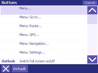 Para asignar o cambiar la función asignación, seleccione el menú
'Ajustes' del menú principal, seleccione 'Botones'. Toque en una de las opciones que figuran a
abrir una ventana de selección de hardkey. Seleccione un botón de la lista para asignarla a una función
elegida. La aplicación tratará de detectar los botones del
dispositivo, pero a veces no es capaz de reconocer los botones de función. Si desea asignar una función a un
botón que no aparece en la lista, debe salir de la lista. La función seleccionada se resaltará en azul. A continuación, pulse una hardkey a asignar a la
función elegida.
Siga las instrucciones indicadas más arriba para asignar funciones, por
ejemplo, a palmphone contexto botones.
Para asignar o cambiar la función asignación, seleccione el menú
'Ajustes' del menú principal, seleccione 'Botones'. Toque en una de las opciones que figuran a
abrir una ventana de selección de hardkey. Seleccione un botón de la lista para asignarla a una función
elegida. La aplicación tratará de detectar los botones del
dispositivo, pero a veces no es capaz de reconocer los botones de función. Si desea asignar una función a un
botón que no aparece en la lista, debe salir de la lista. La función seleccionada se resaltará en azul. A continuación, pulse una hardkey a asignar a la
función elegida.
Siga las instrucciones indicadas más arriba para asignar funciones, por
ejemplo, a palmphone contexto botones.
Lo mismo se aplica a la explotación de la red en un PC: seleccionar un botón del teclado / botón combinación para asignarla a una función seleccionada.
Abreviatura NQ antes de la función nombre significa 'No hay ninguna pregunta', por ejemplo, '(NQ) Start / Stop pista de almacenamiento' significa que puede comenzar a rastrear la grabación sin que se pedirá que introduzca un nombre de archivo, al mismo tiempo '(NQ) Añadir las actuales condiciones de PI' creará un POI con la categoría de la más reciente creación, punto (por defecto: 'Otros') y un nombre tomado de la descripción del PDI en el mapa.
Error de presentación de informes
'Informe de error' es una característica importante que está disponible sólo por asignar a los botones. Esta función le ayuda a enviar el mapa a los errores AutoMapa centro de apoyo. De forma predeterminada, la función se asigna a la Ingresar / dispositivo botón Aceptar. Genera los siguientes archivos en la carpeta de instalación de ruta (por defecto: 'Tarjeta de memoria / AutoMapa UE / Mapas / Mapa del nombre / Errores / AAAA-MM-DD')
imprimir pantalla (en mapa de bits. formato bmp)
GPS pista (. Gps y. Gps.bin archivos)
ruta actual (. atm archivo)
programa de configuración en 'reporte de errores'
Los nombres de los archivos tienen la siguiente estructura:
[posteriores número]. [formato de archivo]
La función
de añadir un POI (categoría: 'AM errores') en el mapa, en el lugar de
su uso.
Ejemplos de uso:
usted nota que la ruta calculada por AutoMapa no es la mejor: ejecutar el 'Reporte de Errores', utiliza el formulario disponible en AutoMapa sitio web para describir el problema y adjuntar la pantalla de impresión y archivo de la ruta.
cuando se conduce, usted nota que AutoMapa ha desempeñado una incorrecta maniobra de mensaje de voz: ejecutar el 'Reporte de Errores', utiliza el formulario disponible en AutoMapa sitio web para describir el problema y adjuntar la pantalla de impresión, vía GPS y la ruta de archivo.
La memoria y la energía
 'Administrar la pantalla y el poder' -, si está activada, esta
opción impedirá que AutoMapa de activar el protector de pantalla o entrar en el
modo de espera cuando se muestran en posición de seguimiento y los modos de
transporte.
'Administrar la pantalla y el poder' -, si está activada, esta
opción impedirá que AutoMapa de activar el protector de pantalla o entrar en el
modo de espera cuando se muestran en posición de seguimiento y los modos de
transporte.
'Mostrar el estado de la batería' muestra el actual estado de carga de la batería (no se visualiza cuando el dispositivo está conectado a red eléctrica).
Utiliza la memoria opciones para cambiar la configuración por defecto especificando la memoria del dispositivo dedicado a los datos de los mapas y puntos de usuario (PDI) en AutoMapa.
Teclado
 En esta ventana usted puede
seleccionar el tipo de teclado (por ejemplo) la búsqueda pueblos o ciudades;
los ajustes disponibles son los siguientes: ABC - cómodo tocando de texto,
QWERTY - estándar de teclado de computadora, y AZERTY - teclado utilizados en
los países de habla francesa y Teléfono - similares teléfono a los teclados, lo
que permite que el programa de operación que usa un dedo, incluso en los PDA
con una pantalla muy pequeña ..
En esta ventana usted puede
seleccionar el tipo de teclado (por ejemplo) la búsqueda pueblos o ciudades;
los ajustes disponibles son los siguientes: ABC - cómodo tocando de texto,
QWERTY - estándar de teclado de computadora, y AZERTY - teclado utilizados en
los países de habla francesa y Teléfono - similares teléfono a los teclados, lo
que permite que el programa de operación que usa un dedo, incluso en los PDA
con una pantalla muy pequeña ..
Para garantizar la comodidad de trabajar en los dispositivos que incorporen en el exterior o conectada teclados, desmarque la 'mostrará automáticamente el teclado'.
Skins
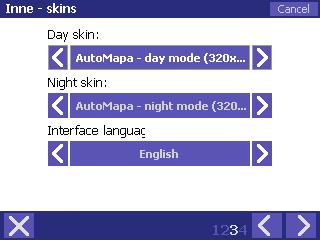 Con esta opción, puede cambiar la apariencia de la
pantalla, elegir uno de los skins disponibles por separado para el día y modo
nocturno.
Con esta opción, puede cambiar la apariencia de la
pantalla, elegir uno de los skins disponibles por separado para el día y modo
nocturno.
En esta ventana también puede cambiar el idioma de la interfaz seleccionada en la primera AutoMapa comienzo.
Otro
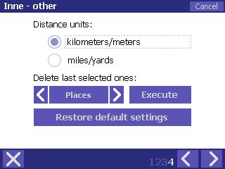 También puede determinar que la
velocidad y la distancia unidades serán utilizados por la aplicación.
Puede elegir entre kilómetros y kilómetros.
También puede determinar que la
velocidad y la distancia unidades serán utilizados por la aplicación.
Puede elegir entre kilómetros y kilómetros.
También puede eliminar el último seleccionado lugares (puntos enumerados en la 'Última seleccionado' en la opción 'Ir a…' del menú) y direcciones (las ciudades y calles seleccionadas en la 'Direcciones' en la opción Ir a… 'del menú).
tIMPORTANTE! Cambiar la configuración de AutoMapa sólo en las paradas. NUNCA en la unidad
Menú Miplo
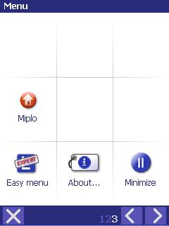 Miplo menú está disponible en
AutoMapa en el menú principal, sólo en el modo experto.
Miplo menú está disponible en
AutoMapa en el menú principal, sólo en el modo experto.
El menú de acceso sólo
es posible tras el registro en Miplo.pl página web.
Miplo las opciones de menú son las siguientes:
|
|
PI Sync Permite adicional de actualización
del archivo de PI |
|
|
MiploLoc Enciende la MiploLoc servicio de encendido / apagado. El LED de la izquierda muestra la opción de actividad. |
Miplo.pl sitio web y PDI
Miplo.pl es un sitio dedicado a las cuestiones de interés (POIs). Los usuarios pueden compartir fácilmente sus propios PDI y descargar otros' PDI. Hay decenas de miles de puntos de utilidad. Los más populares son los que entrega información sobre la ubicación de cámaras de control de velocidad del tráfico y las obstrucciones.
Los usuarios también pueden compartir sus rutas, la aplicación skins, iconos o sonidos utilizados durante la navegación.
MiploSync aplicación
MiploSync solicitud, disponible en la página web, se utiliza para el almacenamiento automático, libre de acción y la descarga de la actualización de PDI. MiploSync permite que los datos sobre los nuevos radares y decenas de miles de otros PDI ser actualizado tanto en el momento de la navegación y en el hogar.
MiploLoc servicio
MiploLoc la AutoMapa permite a los usuarios registrar su ubicación durante el viaje y la presentación del mismo junto con la traza 'en vivo' en Miplo página web. La localización de vehículos se muestra en el mapa utilizando un coche icono, que simboliza también la dirección. Al ver los datos, la siguiente información: fecha y hora de la medición y la velocidad de conducción (si no está reservado).
Para obtener más información sobre el uso del sitio web, así como MiploSync y MiploLoc aplicaciones, consulte www.miplo.pl.
Uso de descargar PDI en AutoMapa
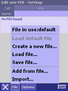 Cuando
usted desea utilizar el archivo descargado PDI para navegar, la aplicación
carga el archivo. Se trata de una sola vez. Futuro
PI actualizaciones serán automáticamente cargados a AutoMapa.
Cuando
usted desea utilizar el archivo descargado PDI para navegar, la aplicación
carga el archivo. Se trata de una sola vez. Futuro
PI actualizaciones serán automáticamente cargados a AutoMapa.
Para cargar el archivo de PI para Automapa, seleccione Configuración - Puntos del usuario en la solicitud. En la ventana que aparece, seleccione Archivo en la parte inferior y, a continuación, carga el archivo. A continuación, apuntar al fichero descargado con el PDI.
La descargado puntos estarán disponibles en la aplicación como de los usuarios PDI. Usted será capaz no sólo de elegir y fácilmente navegar a los puntos seleccionados, pero junto con la descarga usted también recibirá un montón de datos adicionales PDI, al igual que el número de teléfono, horarios de apertura o gama de servicios prestados.
Sistema GPS
AutoMapa utiliza el sistema de navegación GPS para determinar con precisión su posición y lo mostrará en el mapa digital.
Introducción al GPS
 Automático de navegación en AutoMapa utiliza el
Sistema de Posicionamiento Global, disponibles para uso civil de los EE.UU.
Departamento de Defensa. Un receptor GPS calcula la posición midiendo la distancia entre
él y varios (de un total de 24 en funcionamiento) visible de los satélites
Navstar red.
Automático de navegación en AutoMapa utiliza el
Sistema de Posicionamiento Global, disponibles para uso civil de los EE.UU.
Departamento de Defensa. Un receptor GPS calcula la posición midiendo la distancia entre
él y varios (de un total de 24 en funcionamiento) visible de los satélites
Navstar red.
El más satélites el receptor puede detectar, más precisos los cálculos será. Por lo general, tanto como de 4 a 6 satélites son visibles (el número máximo es 12). El número mínimo de satélites necesarios para determinar la posición del receptor es de tres.
Condiciones para la recepción GPS
En condiciones ideales, un típico receptor GPS se utiliza con AutoMapa puede calcular su posición exacta a unos pocos metros. Sin embargo, la señal del GPS puede ser absorbido por las paredes, gruesas árbol coronas, de metal shieldings, o metalizado y con calefacción, ventanas de automóviles. Correspondientes al receptor con una mano o un periódico pueden también, en menor medida, a debilitar la señal. The quality of GPS signal depends on the state of atmosphere, both its upper (eg ionosphere) and the lower layer that influences the weather conditions. La calidad de la señal GPS depende del estado de la atmósfera, tanto su parte superior (por ejemplo, la ionosfera) y la capa inferior que influye en las condiciones meteorológicas. Sometimes, on cloudy and humid days the GPS receiver may have problems with calculating its position. A veces, a nublado y húmedo días, el receptor GPS puede tener problemas con el cálculo de su posición. Otro problema frecuente relacionado con problemas con el GPS es incorrecta lectura de cableado o cerca de dispositivos electrónicos que generan interferencias, y en particular a los dispositivos utilizados para controlar el movimiento de vehículos.
La precisión del cálculo de la posición GPS es mayor, si el receptor GPS antena no está cubierto, preferentemente al aire libre, donde la señal no es absorbida por los edificios o follaje espeso.
Extrapolar posición
AutoMapa está adaptado para la ciudad de navegación y, como tal, está equipada con soluciones GPS mejorar la lectura de la extrapolación de la posición del vehículo basado en el análisis de su dirección y la velocidad. Sin embargo, el mapa puede mostrar una posición fuera de la ruta, por ejemplo, al tomar una rápida vuelta. El 'extrapolar posición' función se puede activar / desactivar la selección de la configuración que desee en 'GPS - Configuración' en el menú principal. En esta opción también se puede especificar manualmente el momento en que se extrapola AutoMapa / GPS supera la posición obtenida del receptor GPS. Este tiempo depende de la velocidad de la CPU, pantalla y tipo de memoria de bolsillo.
La fijación de posición GPS
Si, después de encender el receptor GPS, la 'Búsqueda de señal GPS' se juega, y después de una docena de minutos la posición correcta es que no se encuentra, que significa lo siguiente:
receptor ha sido detectado por AutoMapa, sino que transmite información a no apoya el protocolo (que no sean NMEA 0183), o
automático de detección de puerto COM no, o
Señal GPS es interferido con el resultado de un fracaso del receptor GPS para calcular la posición actual (por ejemplo, el usuario sigue siendo el interior).
Cabe señalar que el llamado de arranque en frío (es decir, tras un largo
período de comenzar la falta de uso) o el primer inicio del receptor GPS puede,
en caso de ciertos modelos, tomar tanto como docena de minutos o más. Antes de iniciar la solución de problemas,
usted debe esperar un tiempo más largo.
Después de calcular la posición GPS, AutoMapa cambia automáticamente al modo de localización por GPS que la posición actual se muestra siempre en el mapa.
La posición actual se indica en el mapa como un círculo palpitante con una flecha de dirección dentro.
Receptor GPS de conexión
Receptor GPS - requisitos
AutoMapa cuenta con el apoyo de los receptores GPS con interfaz COM (es decir, puerto serial para conectar a PC), de relevo que su posición en el GPS protocolo NMEA 0183.
Métodos de conexión
Receptor GPS soporta muchos métodos de conexión de bolsillo, dependiendo de los accesorios suministrados con el dispositivo y el receptor, a saber: conexión por cable, Compact Flash interfaz de radio o de módem Bluetooth.
Algunos receptores requieren ningún software adicional y el apoyo AutoMapa inmediatamente después de la conexión. En caso contrario, deberá instalar el software suministrado con el receptor.
AutoMapa está equipado con un puerto COM escáner que detecta el puerto usado por el receptor GPS para transmitir la información de posicionamiento.
|
Politica de confidentialitate | Termeni si conditii de utilizare |

Vizualizari: 4214
Importanta: ![]()
Termeni si conditii de utilizare | Contact
© SCRIGROUP 2026 . All rights reserved