| CATEGORII DOCUMENTE |
| Bulgara | Ceha slovaca | Croata | Engleza | Estona | Finlandeza | Franceza |
| Germana | Italiana | Letona | Lituaniana | Maghiara | Olandeza | Poloneza |
| Sarba | Slovena | Spaniola | Suedeza | Turca | Ucraineana |
The term periglacial was introduced for the first time by the polish geologist Walery von Lozinski while studying frost weathering conditions in the Carpathians. At first, the word periglacial had been given to the phenomena that occur at the ice sheet margins. Later, the word extended in meaning because scientists realised that periglacial phenomena do not exist only at the ice sheet margins but everywhere where frost action processes dominate. Mainly, we speak about two conditions when mentioning periglacial environment.
1 The freeze-thaw oscillations dominate.
2 The presence of perrenialy frozen ground-permafrost.
It is no perfect spatial corelation between areas of intense frost action and areas underlain by permafrost. There are areas in subarctic regions with intense freeze-thaw oscillations but lack of permafrost. The oppossite is also available. There are areas of relic permafrost but with no intense frost action (Siberia, the boreal forest).
High arctic climates-polar latitudes, extremely weak, diurnal pattern, strong seasonal pattern. Small daily and large annual temperature range.
Continental climates-subarctic latitudes, weak diurnal patterns, strong seasonal patterns, extreme annual temperature range.
Alpine climates-middle latitudes in mountain environments-well developed diurnal and seasonal patterns.
Climates of low annual temperature range-azonal locations:Jean Mayen Isle, Andes summits.
There are 6 main categories:
The development of permafrost with ice segregations, combined with the thermal contraction of the ground under intense cold and the thawing of the same ground.
Frost weathering-desintegration of the rock surface by frost wedging.
The complex of frost activity of the seasonaly thawed layer: soil creep, stone tilting, upfreezing, mass displacement, particle size sorting, frost heaving.
Rapid mass movement- slow flow of water saturated soil (solifluction) or gravity controled rock falls, slope wash process,etc
Fluvial regimes- high level of suspended and bedloaded sediments.
Strong wind action process-nivation and snow patches effects, lack of vegetation, large amounts of glacially derived and frost comunited debris.
The lowering of the temperature of icerich frozen soils leads to a thermal contraction of the ground and the development of fissures: frost fissures or frost cracks. Thermal contractions cracks divide the ground surface up into poligonal nets. The size of the poligons reflects the severity of the climate. The smaller the dimmensions of the polygons the greater is the temperature range.
The frost cracks divide themselves in three categories:
a) Frost cracks filled with ice
b) Frost cracks filled with sand
c) Frost cracks filled with soil
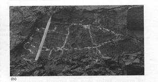
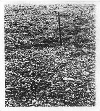
Foto: French, H, 1996, ice veins.
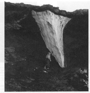
Foto: French, H, 1996, ice wedge.
Ice segregation process: the soil freezes any water present within the soil. This leads to the development of the ice in the soil.
Frost heaving: it represents the upward movement of the mineral soil during freezing caused by the migration of the water to the freezing plane and its subsequent expansion upon freezing. It takes place in the seasonaly thawed layer.
Upfreezing: upward movement of stones and objects in the sediments with coarser particles. There are two theories regarding the mechanism of upfreezing: the frost pull and the frost push. The frost pull explains the upfreezing process in terms of frost heaving. The stones are being pulled to the surface by the pressure difference between the active layer and the freezing plane. The frost push theory brings in the attention the fact that the stones have a greater conductivity and the ice surrounds them, pushing them to the surface.
Stone tilting: it is a result of differential frost heaving at the top and at the bottom of the stone resulting in the rotation and tilting of the axis.
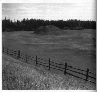
Frost mounds: they can measure from several centimeters to metres. They are a result of cryoturbation. The soil of the frost mounds is characterised by broken and dislocated horizons.
Frost sorting: The paticles that are migrating upwards are sorted into uniform particle sizes.
a) Vertical sorting- freezing and thawing occurs from the top. The larger particles go up while the smaller are being left at the bottom of the active layer.
b) Lateral sorting- freezing and thawing occur from sides. The larger particles are left near the cooling side. The smaller particles have a parabolic movement away from the cooling.
c) Mechanical sorting- The larger particles fall under gravitational influence to the borders of the fine sediments.
Mass displacements: the freezing of soil may generate localised pressures wich have been termed cryostatic. These pressures are hydrostatic by nature since they develop in pockets of unfrozen material wich are trapped between the downward migrating freezing layer and the perennialy frozen ground (permafrost).
B The permafrost
In many periglacial regions a consequence of the long period wintercold and the relatively short period of summer thaw is the formation of a layer of frozen ground that does not completely thaw during the summer. The permafrost is characterised by taliks-unfrozen zones between the bottom of the seasonal frost and the permafrost table (uper permafrost). There are also taliks in the permafrost and below it.
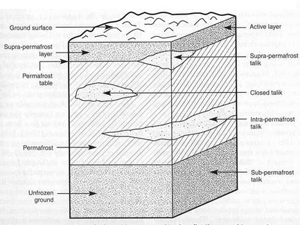
Foto: French, H, 1996, permafrost terminology.
There are two types of permafrost: one that is related to the present climatic conditions, and another one that is a relic permafrost. For example in certain parts of Alaska there is a 360 metres permafrost layer though the mean annual temperature is 5s C (the geothermal gradient is 1s C/ 50 m).
The formation of permafrost depends also of many factors: vegetation, snowcover (insulating factor), drainage, fire, slope orientation, variations in the nature of rocks and soil (different albedo), etc. The most important influence of vegetation is to shield the underlying permafrost from solar heat during the sommer months. That is why the thickness of the active layer is thinnest beneath vegetated areas and thicker beneath well-drained bare soil rock.
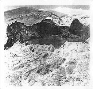
Water exists in permafrost because of the taliks. These taliks are more common in the areas where lakes or a sistem of river channels exist, and they provide space for water to be stored. The role played by permafrost is to act as an impermeable layer for the sub-permafrost waters. Where the permafrost is thin or discontinuous artesian pressures may develop, such that the overlying permafrost is ruptured. If the ground water temperature is not far from os C and if the air temperature is below 0s C, the water may freeze as it rises through the permafrost. The growth of an ice body with its associated frost heave pressures may result in the updoming of the overlying sediments and the formation of a conical ice-cored hill. This hill was named in the periglacial terminology as pingo.
 Where water issues from the ground, sheet like
masses of ice form at the surface in winter. The majority of ground water
icings are small (< 1 m in thickness) but the icing corelated with the
perennial spring may assume considerable dimensions.
Where water issues from the ground, sheet like
masses of ice form at the surface in winter. The majority of ground water
icings are small (< 1 m in thickness) but the icing corelated with the
perennial spring may assume considerable dimensions.
Foto: French, H, 1996, pingo.
In general terms, ground ice may be either epigenetic (develops inside the enclosing rock and after the latter is formed) or syngenetic (it forms almost at the same time as the enclosing sediments are deposited).
When soils are cooled to below 15 to 20s C, there is a schrinkage of the volume of ice held within the soil and this leads to development of cracks and fissures in the frozen ground. The following spring, moisture collects in the fissure and freezes preventing the crack from closing as the ground expands as the temperature rises. Ice wedges join predominantly at right angles and form poligonals nets of patterned ground that cover extensive areas.
Mountain permafrost is not to be confused with plateau permafrost, a term reserved exclusively or the permafrost on the Tibet Plateau. This is because many of the controls over the latter are quite different from those over mountain permafrost, and because mountain permafrost implicitly involves steep slopes aspect and snow. Difficulties arise in determining the lower altitudinal limit of mountain permafrost. The basis of the permafrost zonation is the lapse rate of the temperature wich decreases with the altitude. But in the mountain range, the occurance of cold air drainage, temperature inversions and ice caves complicate the situation. Surface features as the rock glaciers are often used to indicate the lower limit of the mountain permafrost, but this can be controversial. Some rock glaciers may be inactive and not ice cemented in origin but ice-covered.
One method wich appear to work in the mountains of middle latitude is the bottom temperature of the winter snow cover BTS Method. This method is applieble in the Alps and in the Scandinavian Mountains but is useful in Asias midlatitude mountains.
In middle and high latitude mountains, a lower belt of bound solifluction can be separated from a higher free solifluction and patternd ground, their limits being a few hundred metres apart. In the low latitude and arid zone mountains the lower limits of free (or semi-bound) solifluction and of patterned ground almost coincide and form more or less together the lower limit of periglacial altitudinal zone. This in turn is frequently identical with the upper limit of vegetation cover. There exists no altitudinal zone of bound solifluction in these latitudes.
The trend of various lower limits is strongly modified by rock properties. They are affected by the weathering susceptibility of the rocks, the thickness of the weathering mantle, the permeability of the soil and subsoil.
Human interference with the vegetation cover, especially forest destruction and its after effects can cause a depression of the periglacial zone.
C Thermokarst
 It describes irregular
hummocky terrain due to the melting of the ground ice. Subsequently, the term
has been aplied specifically to the process of ground ice melt accompanied by
local collapse or subsidence of the ground surface. The thermokarst usually
apears with the rise of the mean annual temperature, amelioration of the
climate, or with an increase in amplitude of temperature ranges- increase in
continentality.
It describes irregular
hummocky terrain due to the melting of the ground ice. Subsequently, the term
has been aplied specifically to the process of ground ice melt accompanied by
local collapse or subsidence of the ground surface. The thermokarst usually
apears with the rise of the mean annual temperature, amelioration of the
climate, or with an increase in amplitude of temperature ranges- increase in
continentality.
Fluviothermal erosion : the melting of the ice wedges that takes place along the river banks can cause a thermo-erosional niche and the back slumping along ice wedge.
Rock heave: it depends upon the pre-existing fracture characteristic of the bedrock. The geomorphic expression can vary from single ejected blocks to dome shaped accumulations up to several metres in diameter. Usually, the upward displacement is the result of excess water pressures created in the zone between the permafrost table and downward freezing.
D Cryoturbation and patterned ground
Cryoturbation can vary from sorted or nonsorted circles to poligons, nets or stripes. The patterned ground is polygenetic and similar forms can be created by different processes. Circles are a result of cryoturbation- lateral and vertical displacemen of soil wich accompanies seasonal or diurnal freeze-thaw cycle.
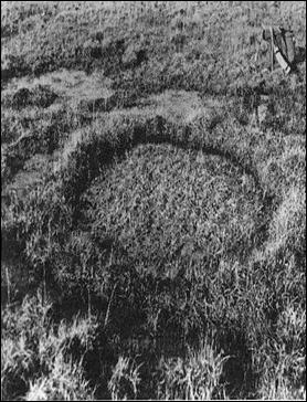
Fotos: French, H, 1996, non-sorted circle (left), poligons net (right).
Mudboils- They consist of round and elongate , 1-2 metres in
diameter bare soil patches. They develop in poorly sorted sediments (muds) with
significant silt or clay content. The natural moisture contents of the
sediments are very near the liquid limits so the muds liquefy and flow readily
in response to slight changes in moisture content or slight internal or
external stress. When the stress can not be relieved by downslope movement, mud
may burst through the semirigid surface to create a mud-boil.This happens in
late summer, when the active layer thickness is the greatest.
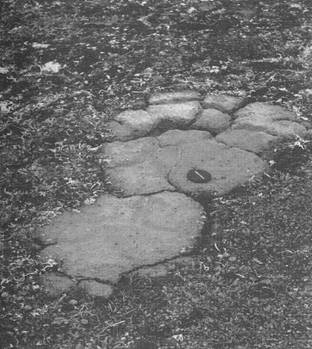
Foto: French, H, 1996, mudboil.
Mass waisting- the downslope movement of debris under the influence of gravity.
Solifluction- occurs not only in cold climates. So another term, used only for periglacial areas was proposed (Washburn): gelifluction.
Frost creep the downslope movement of particles as a result of the frost heaving of the ground and the subsequent settling upon thawing, the heaving being predominantly normal to the slope and the settling more nearly vertical.
Gelifluction Conditions suitable for gelifluction occur in areas where downward percolation of water through the soil is limited by the frozen ground and where the melt of the segregated ice lenses provides excess water wich reduces internal friction and cohesion in the soil. Andersson named it: slow flowing from higher to lower ground of masses of waiste saturated with water. Geomorphic features produced by the gelifluction and the frost creep are : solifluction sheet and solifluction lobes
Solifluction sheet: it has low angles (1-3 ) is a result of extensive gelifluction and frost creep. The sheets are capable of transporting large erratic boulders.
Solifluction lobes: usually occur in alpine areas. They give rise to a stepped slope in angle from 3-5 to 15-20 . Fo lobes to develop, gelifluction must be greater than frost creep process. Particularly favoured locations for the development of the lobes are immediately below snow patches and on the lower parts of the valley slopes. Some slopes are marked by a concentration of large stones or boulders at their downslope ends. These have been named stone garlands, block-banked terraces or boulder steps.
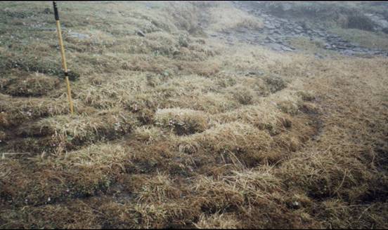
Foto: Palade, B, 2001, solifluction.
Slope wash It is not unique to the periglacial environment but it occurs widely in the periglacial areas- perticles are carried along in an overland flow . If the flow gets thicker, it becomes progressively concentrated into smaller channels of higher intensity of erosion to give differential denudation. Vegetation has the major influence upon the rate of sediments transport. Vegetation intercepts precipitation stopes the impact of the rain drops and improves soil structure.
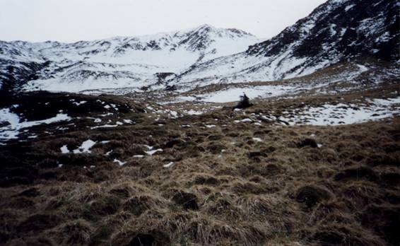
Foto: Palade, B, 2001, patterned ground.
Debris flows and avalanches - occur in the high mountain relief. Most avalanches start as snow avalanches wich then pick-up varying amounts of rock debris- debris avalanches.
Debris flows rapid movements of masses of rock and/or debris gliding on one or several slide planes.
Rock falls the melting of the interstitial ice and the loosening of the rock particles by frost wedging in the small joints and fractures.
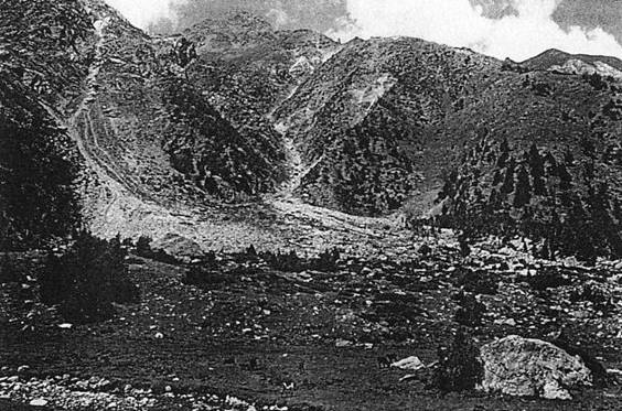
Foto: Shroder, J, Bishop, M, ?, debris falls in Nanga Parbat.
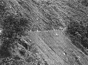
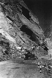
Foto: Shroder, J, Bishop, M, ?, rock falls in Hunza Valley -Karakoram Highway
(left), landslide (right).
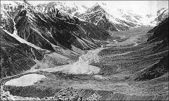
Rock glaciers
Rock glaciers are thick, lobate or tongue like masses of angular debris that move sowly downslope as a consequence of the deformation of the internal ice or frozen sediment.
Protalus rock glaciers - they form through the deformation of the talus containing interstitial ice derived from meteoric water and form steep-like or lobate extensions.
Morainic rock glaciers they form through the burrial and subsequent deformation of glacier ice under a thick cover of debris. Some landslides are directly relevant to the formatoin of rock glaciers because they bury glaciers and provide large amounts of supraglacial debris.
In the Karakoram the largest rock glaciers observed at present occur between Shimshal and the Khunjerab Pass and are best developed along the Drui Nadi Valley. X
Many of the rock glaciers are derived from prominent moraines from wich the local glaciers have retreated. Many of the rock glaciers are between 1-2 km long and 0,3 km wide, and have multiple lobs up to 15 m in relief. These extend down to elevations of between 4 800 m to 4 500 m asl.
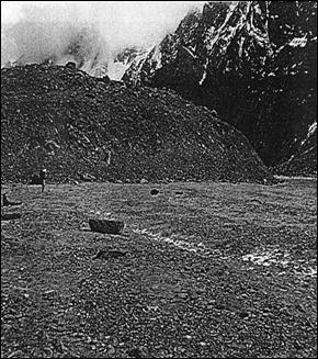
Foto: Shroder, J, Bishop, M, ? rock glaciers in Karakoram.
The massive nature of these glaciers (> 15 m thick) and the steep margins indicate a sizeable thickness of burried ice. Protalus rock glaciers are also present in the Drui Nadi Valley, but their development is restricted to eastern slopes wich range from about 25 to 35
Asian high mountains
Asian high mountains divide themselves in the arid cotinental mountains and humid continental mountains. The border between the two regions is often transitional, such that some continental mountains show composite features. For instance, in the Karakoram, lower mountains (< 3000-4000 m) are arid, while higher mountains receive a large amount of precipitation mainly derived from the winter westerlies.
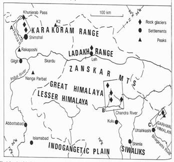
Foto: Hewitt, K, jahr.,map of the
western Himalaya.
Permafrost distribution It can be determined (the lower limit) by a variety of methods including: mapping of indicative landforms: rock glaciers, frost mounds; measurement of groud temperature; geophysical soundings of electric sensitivity and seimic velocity; direct observations: excavating, driling.
However, the lower limit is rarely a sharp line. It is mainly irregular due to the vegetation, snow distribution, etc. Islands of permafrost can occur well below the average elevation of the lower limit. The lower limit of pemafrost (Hp) ascends southwards with the general increase in temperature and westwards with the continentality. The lapse rate is 160 m per degree of latitude.
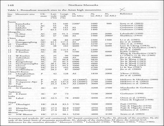 Foto: Matsuoka, N,
permafrost altitudes in Asian High Mountains
Foto: Matsuoka, N,
permafrost altitudes in Asian High Mountains
Snow line altitude (Hs) lies above the Hp. The height difference between the two lines DHsp = Hs-Hp varies considerable between the humid continental mountains (100-900 m) and arid mountains (600-1400 m) with a borderline around 700 m. Hp also lies between the timberline (Ht) and the snow line. Between these two lines, diurnal or annual freeze-thaw action ( frost shattering, heave, sorting, solifluction) are operative on both the bare ground and meadow vegetated ground, producing periglacial landforms.
The lack of moisture in the arid continental mountains, on one hand enlarges the periglacial belt both upwards by raising the snowline, and downwards by preventing the growth of trees. On the other it generaly prevents freeze-thaw action responsible for periglacial features, except near lakes, glaciers or snow patches. These conditions combine to produce a large area of cold arid environments with only sporadic occurances of typical periglacial forms in inland high mountain areas like Karakoram, Tibetan Plateau, Pamir.
In more humid areas, an absence of grazing activity permits the development of a zone of creeping pines (pinus pumila) above the timberline , wich raises the lower limit of the periglacial belt by restraining the freeze-thaw action.
 With respect to a vertical
zonation, rocky or stony periglacial features dominate over the upper part of
the periglacial belt regardless of the humidity, reflecting the lack of
vegetation and the abundance of coarse fragments produced by physical
weathering.
With respect to a vertical
zonation, rocky or stony periglacial features dominate over the upper part of
the periglacial belt regardless of the humidity, reflecting the lack of
vegetation and the abundance of coarse fragments produced by physical
weathering.
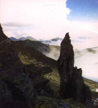
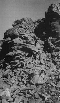
Foto: Palade, F, 1999 (left) , French, H, 1996 (right), bedrock weathering.
The predominant features are tors, block fields and rock glaciers. Landforms associated with fine debris, including stony (sorted) patterned ground and stone-banked lobes, occur mainly in three situations: a) where the regolith originates from some specific lithologies; b) where the ground is covered by till; c) where the vertical shift of the alpine vegetation zone during the Holocene once permitted soil development on terrain now lacking vegetation. This upper subbelt is the zone of free solifluction.
Towards the lower parts of the periglacial belt, turf (partly or fully vegetated, periglacial features represented by turf-banked lobes (or terraces), arid earth hummocks replace the stony features in response to the soil formation beneath the alpine vegetation. Such turf features can develop well below the regional lower limit of the periglacial belt, where the diurnal or annual freeze-thaw cycles are accompanied by local moisture sources.
The transition from the stony to the turf subbelt is usually gradual depending on the irregular distribution of alpine vegetation. This cotrasts with the distribution of active rock glaciers, wich is delimited by the lower limit of the permafrost.
Although a variety of phenomena have been found in Asian arid Mountains, the paucity of moisture is generaly unfavourable for superficial periglacial processes. In the Karakoram salt weathering may dominate over a large part of the terrain on semi-aid mountains while increasing moisture availability allows frost weathering to become significant near the snow line where shattered cliffs and block fields are common.
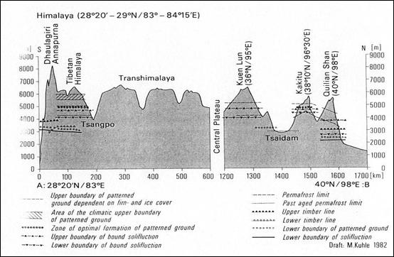
Tabloid: Kuhle, M, 1982, distribution of patterned ground.
Melting of a frozen rock mass in the latter locations can also trigger frequent falls and occasional large rock avalanches- example of what happened around Bualtar glacier during the summer of 1986. Patterned ground and frost mounds also occur along lakes, streams, late lying snow patches or on glacier forelands. Despite the low precipitation, permafrost moisture surces may promote solifluction in the lower of the active layer. This process, associated with annual freeze-thaw may produce block streams and turf banked-lobes. Where water percolation in the permafrost produces an ice rich layer, rock glaciers can develop. The large vertical extent of the permafrost layer in these mountains, represented by a large DHsp value, allows ice development of elongated block streams and rock glaciers (more than one km in lenght).
In many places, periglacial features are caused by animals: some terraces or lobes on slopes may originate from yak grazing.
Cryogenic weathering
In the Karakoram mountains, year-round monitoring of rock surface temperatures indicates that large diurnal temperature ranges permit the rock surface to experience high heating/cooling rates possibly effective in rock breakdown by thermal stress although frost action may also operate after significant snowfalls. Frost weathering is effective also on rockfalls far below the timberline.
Tabloid: : Hewitt, K, jahr..,the frequency of freeze-thaw cycles in
Karakoram
Solifluction
The rate of movement of the soliflucion lobes in the Karakorum depends mainly on the slope gradient , moisture and vegetation. The average rates are 2-3cm/ 1/a. The surface movement is faster on turf- free slopes (10 cm) than on turf covered lobes (1 cm). The maximum depth of movement: 40 cm (gelifluction) to 100 cm (plug-like flow).
Debris depositions by snow avalanches was also evaluated in the frontal ranges of the Punjab Himalaya, Pakistan: 0,2- 0,7 mm 1/a.
Throughout the Karakoram the bulk of precipitation is snow fall, and entirely so above about 4 800 m. Both he duration and amount of snow on the ground are important indicators of the geomorphic conditions, and their distribution by altitude is indicated in X.
Diurnal freeze-thaw cycles are present in Karakoram, althogh its full impact by way of cryogenic processes is felt only where the belt migrates into altitudinal bands wich have relatively abundant moisture. In most areas this involves elevations above 4 000 m and below 6 000 m.
The transportation of moisture from high cold areas to intermediate altitudes by avalanching and glacier flow together provide for a huge increase of moisture between 3500 m asl and 5000 m asl. Here precipitation is moderate, ranging from 250 mm to 800 mm. The available heat in the melt season is capable of ablating much more in the glacier ablation zone, there is s progressive downglacier increase in amount and thickness of the debris cover. On some glaciers such as Baltoro the lowermost few kilometers or tens of kilometers are completly masked by debris.
So, avalanche snow and the melt water derived from it is the main source for widespread Karakoram debris-mudflow activity and for the majority of streams that persist after the main snowmelt has passed.
Cryogenic processes are at their most active in the vicinity of the snowline, therefore a moisture supply and bare ground coincide with the zone of frequent frost cycles. Below this zone, the intensity or duration of active erosion and deposition generally becomes progressively more confide along drainage axes. Even along drainage lines processes tend to become increasingly moisture- starved and debris rich in a downslope direction. The altitudinal range of the drainage lines also plays an important role. Abundant avalanches solifluction, meltwater stream and lacustrine features occur above 4000 m. Debris and mud flow deposits, earth pillars and other bad-lands forms, salt weathering and eolian features predominate below that level.
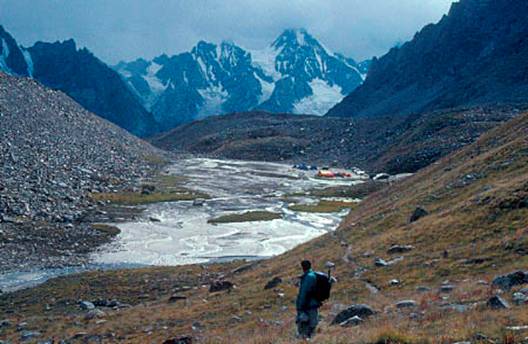
Foto: Internet resource, solifluction, rock glacier.
The zone III is a cool subhumid belt with warm summers. There is a moderate winter snow fall and snow lies on the ground for 3-8 months. Several weeks of freeze-thaw cycles occur in spring and autumn, and there is a summer drought. The lower ablation zones of glaciers are characterised by thick debris covers. Heavy summer grazing has helped to give much of the area a dry steppic character. There are extensive areas of steep slopes where seasonal rockwall processes are important.
Many ridges and lesser peaks culminate at heights between 4000-7000m asl. On more round summits at the lower elevations in zone II, well developed cryogenic forms occur- block fields, stone poligons, solifluction lobes. They are rarely seen even on gentler areas below the summits because they are overwhelmed by debris and moisture from above.
The great screes of the region also mostly originate from watersheds at the upper limit of zone II.
Most of the rock glaciers of Central Karakoram occur along ridges and peaks between 4500 m and 5500 m asl.
Rockwall conditions themselves have their most significant expression in zone II, where the highest frequency of rockfalls and rockslides and their most extensive deposits occur.
Slopes in zone III are starved of moisture so that sediment delivery at the base of them is proportionaly restricted. Unless the valley walls descend from much higher elevations, contemporary deposits are confined in minor spring mudflows and slopewash, patterned talus and minor rockfalls debris.
Between about 3500-5000 m the depositional complex is abundant in rockfalls , rockslides, debrisflows. Where avalanches do not reach the terrace, melt water from them tends to cary large amounts of debris from steep chutes or canyons including occasional large debrisflows. These form depositional cones across the terraces X. The rock avalanche can measure from 5 to 35 m in thickness and may be 150-200 m wide. They have boulders with diameters 4-45 m. This kind of rock avalanche can force a glacier to surge (Bualtar glacier was covered in 1986 with 4,2 km of debris).
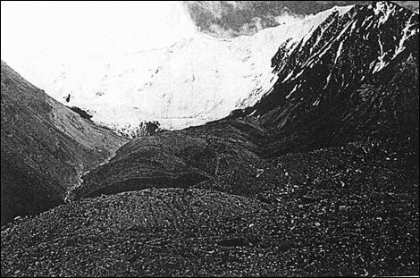
Foto: Shroder, J, Bishop, M, ?, morainic rock glacier in Karakoram.
Mass movement
Hewitt has described the organization of the geomorphic processs in the Karakoram in term of altitudinal controls on precipitation and freeze-thaw cycles that produce a great variability in mountain sediments. In course of long term-denudation these sediment sources are distributed in the uplands and then the sediment they suplly is reworked progressively downstream along the himalayan glacier and river valleys.
The Himalaya have the greatest subaerial relief available, high potential energy, high seismicity, steep slopes, strong weathering, plentifull surfaces of bare rock, powerfull and torrential storms, great snow and ice avalanches.
Massive rock slides and catastrophic debris flows have been an object of amazement in the Himalaya.
The slopes of stratified debris are clasified in two groups: one of steep 30-38 slopes of rock fragments that accumulated as a result of falls of single particle-rocks, grain flows and flows of viscous debris; and a second of gentler 9-30 slopes from falls of single particle rocks, slope wash and thin flows of viscous debris.
Debrisflows and debris slides are very common on many deposits of regolith and rubble, and catastrophic flows of debris are frequent during the monsoon rains.
The most dramatic element of the landscape are the slopes of polygenetic scree (talus). The landforms varied in character up to huge accumulations of compouned debris with slope lenghts as much as 1000 m. Slope angles were measured at 25-35 and rarely up to 40. The International Karakoram Project noted in particular the steep alopes: extensively fractured bedrock, comon salt weathering, freeze-thaw cycles. The regime of rockfalls and debrisflows shows that small rockfalls are annual and large debrisflows occur once in 5-10 years.
Extreme vertical zonation of clima-geographic conditions reflects the relations of great relief and steep slopes to moisture availability. Most of the precipitation occurs as snow and it exceeds 1000 mm between 5000-7000 m. This involves huge downslope movements of moisture and sediment from higher, colder and more humid zones to lower, drier areas by: avalanches, meltwater streams, glacierflow, wet mass movements.
 In the Karakoram many
avalanches were split into several lobes moving up and down valleys→into
main valleys.
In the Karakoram many
avalanches were split into several lobes moving up and down valleys→into
main valleys.
Foto: Shroder, J, Bishop, M, anul, debris covered glacier in Nanga Parbat
Slope failures
Slope failures were monitorised in the Kaghan Valley. Kaghan Valley is a great V shaped valley with high level terraces that result from a combination of uplifting of the himalayan surfaces cupled with glacial and periglacial erosion. Because the Karghan region is on the south side of the western Himalaya and also faces south, it is more open to the summer monsoon. Also, because it is on the frontal Himalaya, it is not in deep rain shadow from surrounding higher peaks. In addition , winter storms track from the west trough the region and produce considerable precipitation. Because of this, Karghan Valley has many trees on its steep slopes, thick forest soils and regolith. Extensive deforestration in the lower regions has contributed to the widespread rock debris, debris slides, avalanches and flows. Usually, the landslides are marked at their ends by hummocks, 2-4 meters high.
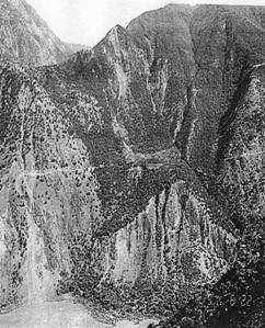
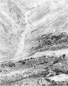
Foto: Shroder, J, Bishop, M, landslides in Nanga Parbat
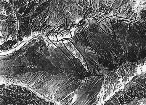
Foto: Hewitt, K, jahr..slope failures in Hunza Valley, Karakoram.
|
Politica de confidentialitate | Termeni si conditii de utilizare |

Vizualizari: 4210
Importanta: ![]()
Termeni si conditii de utilizare | Contact
© SCRIGROUP 2025 . All rights reserved